Download
3D Flyover
Add to list
More
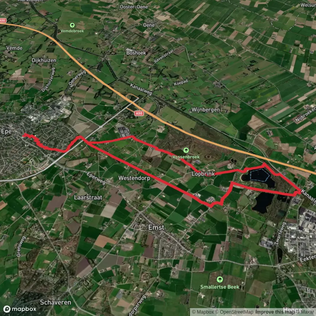
12.2 km
~2 hrs 26 min
0 m
Loop
“Wander the Loobrinkerpad for a vibrant tapestry of Emst’s tranquil streams, lush forests, and living history.”
Embarking on the Loobrinkerpad offers a delightful 10-kilometer (approximately 6.2 miles) journey through the picturesque countryside of Emst, Netherlands. This circular route, marked by purple clog symbols, guides you across diverse landscapes, including agricultural fields, serene streams, and lush forests.
Starting Point and Initial Stretch
The hike commences at Dorpshuis De Hezebrink, located at Ds. van Rhijnstraat 69 in Emst. From here, the trail leads you out of the village, quickly immersing you in the tranquil rural environment. As you proceed, you'll traverse small roads and paths that meander through open fields and along the Smallertse Beek, a stream historically significant for its role in the local paper industry. This area is rich in flora, with clear waters supporting species like the marsh marigold and valerian. (noordwestveluwe.knnv.nl)
Recreatiegebied Kievitsveld
Approximately 3 kilometers (1.9 miles) into the hike, you'll enter the Kievitsveld recreational area. This region features several ponds, notably the Smallertse Plas and Nijmolense Plas, both created through sand extraction during the construction of the A50 highway. The Smallertse Plas is equipped for day recreation, including a waterskiing facility, while the Nijmolense Plas and adjacent historic fish ponds offer a more natural setting, attracting various bird species and providing opportunities for birdwatching. (birdingplaces.eu)
Nature Reserve Het Vossenbroek
Continuing the journey, the trail leads you to the Vossenbroek nature reserve, a low-lying area characterized by its wetland ecosystem. This reserve is home to one of the few natural alder carr forests in the Netherlands, where trees like the black alder thrive in waterlogged conditions. The area supports a variety of plant species, including the broad-leaved marsh orchid and the greater yellow-rattle. Wildlife such as foxes, roe deer, and various bird species inhabit this region, making it a haven for nature enthusiasts. (nl.wikiloc.com)
Historical Significance
The Loobrinkerpad also offers glimpses into the area's rich history. As you walk, you'll encounter remnants of the former "Baronnenlijn," a railway line established in the late 19th century to connect Apeldoorn with Hattem. This line was notably used by the nobility, hence its name, and operated passenger services until 1950. Today, parts of the old railway have been transformed into cycling and walking paths, allowing hikers to tread along these historical routes. (suzannevdijk.wordpress.com)
Trail Conditions and Recommendations
The Loobrinkerpad comprises both paved and unpaved sections. Certain parts, especially through the Vossenbroek, can become quite muddy, particularly after rainfall. It's advisable to wear sturdy, waterproof footwear to navigate these areas comfortably. The trail is well-marked with purple clog symbols, but carrying a navigation tool like HiiKER can enhance your hiking experience by providing detailed maps and real-time updates.
Access and Transportation
For those traveling by car, parking is available at Dorpshuis De Hezebrink, the starting point of the hike. If you're using public transportation, the nearest bus stop is Hezeplein in Emst, which is a short walk from the trailhead. (klompenpaden.nl)
Embarking on the Loobrinkerpad provides a comprehensive experience of Emst's natural beauty, historical landmarks, and diverse ecosystems, making it a rewarding adventure for hikers of all levels.

Surfaces
Asphalt
Unknown
Concrete
Grass
Paved
Ground
Wood
Comments and Reviews
User comments, reviews and discussions about the Smallertse Plas via Loobrinkerpad, Netherlands.
average rating out of 5
0 rating(s)