Download
3D Flyover
Add to list
More
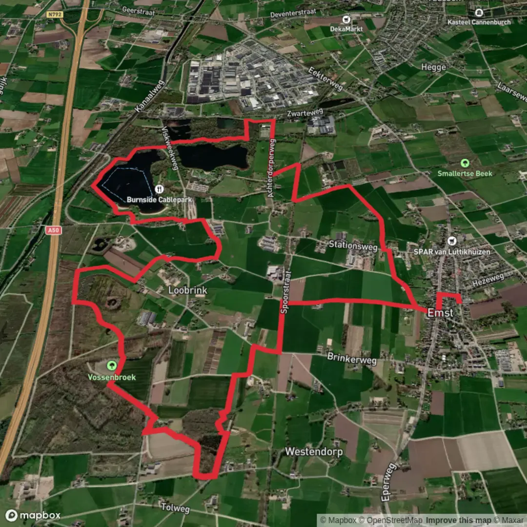
10.8 km
~2 hrs 9 min
0 m
Loop
“Wander the Loobrinkerpad for a vibrant tapestry of ponds, forests, and timeless Dutch countryside charm.”
Embarking on the Loobrinkerpad, a scenic 11-kilometer (approximately 6.8 miles) loop trail near Emst in Gelderland, Netherlands, offers hikers a delightful journey through diverse landscapes, including serene ponds, lush forests, and rich agricultural fields. With minimal elevation gain, this easy-rated trail is well-suited for hikers of all levels.
Getting to the Trailhead
The Loobrinkerpad begins in the village of Emst, located in the province of Gelderland. For those traveling by car, free parking is available at Zwarteweg, Schobbertsweg, or Viskweekweg. If you're using public transportation, the nearest major city is Apeldoorn. From Apeldoorn, you can take a bus to Emst; however, it's advisable to check the latest schedules and routes on local transit websites or apps to ensure a smooth journey.
Trail Overview
Starting from Emst, the trail is marked with signs featuring a purple clog, guiding you through the picturesque countryside. The path meanders through open fields and along gentle streams, leading you to the Nijmolense Plas and Smallertse Plas. These ponds, created through sand extraction for the construction of the A50 highway, have since transformed into tranquil recreational areas. The Smallertse Plas, in particular, is equipped with two beaches, making it a popular spot for day visitors. (birdingplaces.eu)
Exploring the Ponds
As you approach the Nijmolense Plas, you'll notice its naturalistic setting, offering a peaceful environment for birdwatching and relaxation. Continuing to the Smallertse Plas, the trail encircles the water, providing ample opportunities to appreciate the aquatic landscape and perhaps spot local wildlife.
Through Loobrink and Vossenbroek Nature Reserve
Beyond the ponds, the path leads you to Loobrink and the Vossenbroek nature reserve. Vossenbroek spans approximately 80 hectares and is one of the few areas in the Netherlands with natural swamp forests. Here, black alders stand with their roots submerged in water, creating a unique ecosystem. The reserve is home to diverse flora and fauna, including foxes, roe deer, badgers, marsh marigold, broad-leaved marsh orchid, and blue sedge. (nl.wikiloc.com)
Historical Significance
The region around Emst is steeped in history. The ponds you encounter were formed during sand extraction activities for the A50 highway construction, reflecting the area's industrial past. Additionally, the Vossenbroek nature reserve offers a glimpse into the Netherlands' natural heritage, preserving landscapes that have remained largely unchanged for centuries.
Trail Conditions and Navigation
The Loobrinkerpad consists of unpaved paths that traverse meadows, agricultural lands, and farmyards. While the trail is well-marked, carrying a reliable navigation tool like HiiKER can enhance your hiking experience by providing detailed maps and real-time updates.
Additional Information
The trail can be shortened to 7 kilometers (approximately 4.3 miles) if desired, with clear signage indicating the alternative route. It's important to note that dogs are prohibited on private sections of the trail to prevent disturbance to livestock and wildlife. This restriction is clearly indicated on signs at the beginning of private properties. (veluwe.nl)
Embarking on the Loobrinkerpad offers a harmonious blend of natural beauty, historical insights, and a peaceful hiking experience in the heart of Gelderland.

Surfaces
Asphalt
Ground
Unknown
Sand
Concrete
Grass
Unpaved
Wood
Comments and Reviews
User comments, reviews and discussions about the Smaalertse Plas and Nijmolense Plas via Loobrinkerpad, Netherlands.
average rating out of 5
0 rating(s)