Download
3D Flyover
Add to list
More
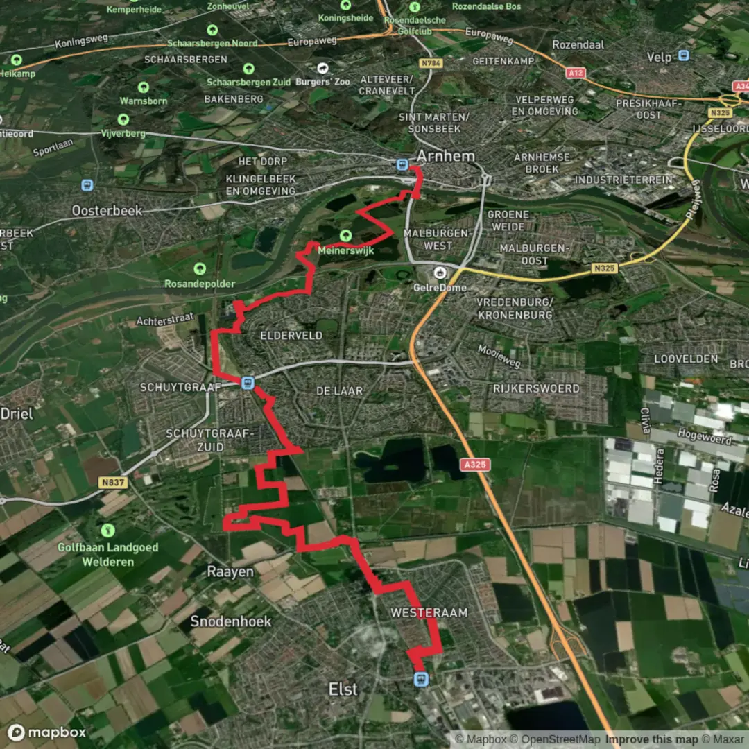
16.0 km
~3 hrs 12 min
7 m
Point-to-Point
“Stroll through Gelderland’s timeless fields, tranquil wetlands, and echoes of history, where nature and heritage entwine.”
Starting from the outskirts of Elst, this 16 km (about 10 miles) route offers a flat, easy walk with virtually no elevation gain, making it accessible for most hikers. The trailhead is conveniently located near Elst railway station, which is well-served by trains from Arnhem and Nijmegen, and also accessible by car with parking available at the station or nearby streets.
Getting Oriented and Setting Out
The route begins just south of Elst’s town center, a short walk from the station. Heading out, you’ll quickly leave the urban edge behind, entering a patchwork of open fields and tree-lined paths. The landscape here is quintessential Gelderland: broad, flat agricultural land interspersed with small woodlands and watercourses. Navigation is straightforward, but for precise wayfinding and to track your progress, HiiKER is highly recommended.
Zuidelijke Plas and Wetland Wildlife
After about 4 km (2.5 miles), you’ll reach Zuidelijke Plas, a tranquil lake surrounded by reeds and marshland. This area is a haven for birdlife—look for herons, grebes, and sometimes even kingfishers darting along the water’s edge. The path skirts the lake, offering several quiet spots to pause and enjoy the scenery. In spring and early summer, wildflowers line the banks, and the air is alive with the calls of waterfowl.
Percksepad and Rural Heritage
Continuing west, the trail joins the Percksepad, a historic path that once connected local farms and villages. Here, you’ll pass through a landscape shaped by centuries of agriculture. Traditional Dutch farmhouses, some dating back to the 19th century, dot the route. The flat terrain makes for easy walking, and the open vistas are punctuated by rows of poplars and willows. At around the halfway point, you’ll cross several small canals—reminders of the region’s long history of water management.
Central Arnhem and Cultural Highlights
The final stretch leads you toward the southern edge of Arnhem, ending near the Central Arnhem area, close to the well-known Park Sonsbeek. This park is a local landmark, famous for its rolling lawns, historic watermills, and art installations. The proximity to Arnhem’s city center means you’re never far from cafés, museums, and public transport connections for your return journey.
Practical Tips and Wildlife
The entire route is well-marked and mostly follows paved or gravel paths, with occasional grassy sections that can be muddy after rain. There are several benches and picnic spots along the way, especially near Zuidelijke Plas and Park Sonsbeek. While the trail is easy, weather can change quickly, so pack a light rain jacket and plenty of water. Dogs are welcome but should be kept on a leash in nature reserves.
Historical Context
This region of Gelderland has a rich history, from Roman settlements near Elst—where ancient temples once stood—to the strategic importance of Arnhem during World War II. The landscape you traverse has been shaped by centuries of farming, trade, and water engineering, and remnants of this past are visible in the old farmsteads and canal systems.
For navigation and up-to-date trail conditions, consult HiiKER before setting out. Public transport links at both ends make this route ideal for a linear day hike without the need to double back.

Surfaces
Asphalt
Unknown
Concrete
Grass
Unpaved
Paved
Comments and Reviews
User comments, reviews and discussions about the Elst to Central Arnhem via Zuidelijke Plas and Percksepad, Netherlands.
average rating out of 5
0 rating(s)