Download
3D Flyover
Add to list
More
26.3 km
~5 hrs 19 min
44 m
Point-to-Point
“A flat borderland ramble from Eibergen’s lanes to bog boardwalks and heath-sand woods—plan for wind and mud.”
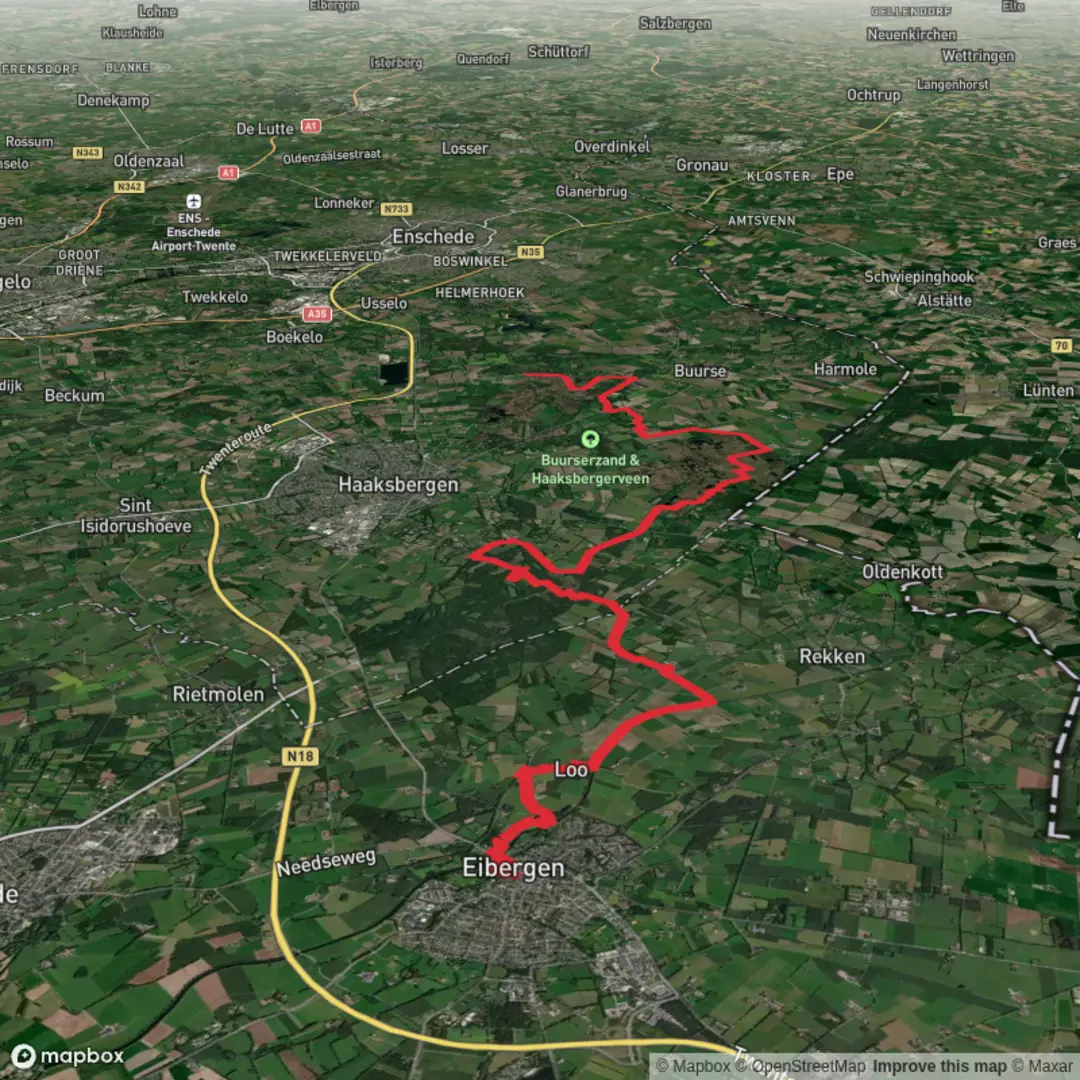
This is a long, flat, lowland walk through the eastern Dutch border region, linking village edges, quiet farm lanes, and three standout nature areas: Haaksbergerveen (raised bog), Buurserzand (heath, sand, and woodland mosaic), and the broader stream-and-meadow landscape that ties them together. At around 26 km / 16.2 mi with roughly 0 m / 0 ft of climbing, it’s physically straightforward, but it’s a full day on your feet—plan for time, weather exposure, and a few potentially muddy sections.
Getting to the start (Eibergen)
Because the start point is listed only as “near,” the most reliable “start area” to aim for is Eibergen town center, where services and transit are concentrated. A practical landmark to navigate to is Eibergen’s central area around the main shopping streets and bus stops (commonly the hub for local buses). If you’re using HiiKER for the route line, set your start near Eibergen centrum so you can adjust to the exact trailhead point shown on the track.
By public transport (Netherlands): - Eibergen does not have its own train station; most visitors arrive by train to a nearby station (often in the Achterhoek region) and continue by regional bus into Eibergen. Check the day-of schedule because rural frequencies can drop outside commuting hours and on Sundays. - If you’re coming from Germany, connections via border-region rail/bus nodes are possible, but expect transfers.
By car: - Eibergen is easy to reach via regional roads through the Achterhoek. Parking is typically simplest at public car parks near the town center or at signed parking areas near nature reserves (where permitted). If you plan to finish elsewhere (point-to-point), consider staging a second car or using a bus/taxi back.
What the terrain is like (and why “easy” still needs planning)
You’ll be on a mix of paved cycle paths, compacted gravel, sandy tracks, and boardwalk/peat-edge paths. With essentially no elevation change, the main challenges are: - Distance: 26 km / 16.2 mi is a long day for many hikers. - Underfoot conditions: after rain, peatland edges and sandy-heath connectors can be slick, soft, or churned. - Exposure: open heath and farmland can feel windy and cold even when nearby towns feel mild.
Footwear: light hiking shoes are fine in dry spells; after wet weather, water-resistant footwear helps, especially around bog margins.
Eibergen outskirts to Haaksbergerveen (approx. 8–10 km / 5–6.2 mi)
Leaving Eibergen, the route typically transitions quickly from village streets to the Achterhoek’s patchwork countryside—hedgerows, drainage ditches, small woodlots, and long, straight paths that reflect centuries of land management. Expect: - Quiet farm lanes with occasional local traffic (bikes, tractors). Stay alert on bends and narrow verges. - Birdlife in field margins and wet ditches: lapwings and geese in season, plus herons and small passerines along hedges. - Wind: the openness can make this section feel longer than it looks on a map.
As you approach Haaksbergerveen, the landscape subtly changes—more wet ground indicators (rushes, darker soils), and a sense of entering a protected area.
Haaksbergerveen: raised bog character and boardwalk walking (approx. 3–5 km / 1.9–3.1 mi within/along the reserve)
Haaksbergerveen is one of the region’s signature habitats: a peat bog system shaped by both natural processes and historic peat extraction/drainage. Even if the route skirts rather than fully crosses the wettest core, you’ll notice: - Spongy ground and waterlogged hollows - Bog vegetation (heathers, sedges, mossy patches—often with a distinctly “open” feel compared to surrounding woodland) - Straight drainage lines in places—reminders of older land-use practices aimed at drying peatlands
Wildlife to look for: - Dragonflies and other insects in warmer months near open water and wet margins - Raptors (buzzards are common in this part of the Netherlands) circling over open ground - Deer can appear at the edges where bog meets woodland, especially early/late in the day
What to watch out for: - Mud and slick boards: if there are boardwalk segments, they can be slippery when wet or frosty. - Staying on the path: bog habitats are fragile; stepping off-trail can damage vegetation and is often unsafe due to hidden soft spots.
Historical context: peatlands across the eastern Netherlands were long valued as a fuel source. The remaining bog fragments are ecologically important precisely because so much was altered or drained over past centuries.
Connecting lanes and woodland edges toward Buurserzand (approx. 8–10 km / 5–6.2 mi)
Between the reserves, you’ll likely stitch together forest edges, sandy tracks, and rural connectors. This is the “cruising” portion—flat, steady, and ideal for settling into a pace. Expect: - Mixed woodland (often pine and deciduous stands) with straight forestry lines - Sandy patches underfoot where paths cross drier soils—these can feel surprisingly tiring late in the day - Borderland atmosphere: this region sits close

Surfaces
Unknown
Asphalt
Grass
Ground
Unpaved
Sand
Wood
Dirt
Concrete
Comments and Reviews
User comments, reviews and discussions about the Eibergen to Buurserzand via Haaksbergerveen, Netherlands.
average rating out of 5
0 rating(s)