Download
3D Flyover
Add to list
More
32.7 km
~6 hrs 44 min
124 m
Point-to-Point
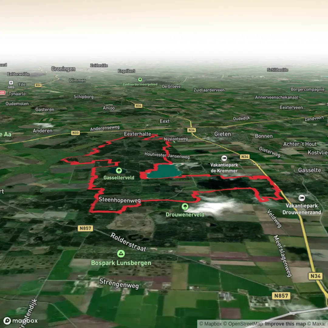
“A full-day wander along the Hondsrug: sandy forest lanes, heather horizons, and Gasselterveld’s glassy shores.”
This is a long, low-stress day out on the Drenthe sand ridge of the Hondsrug: wide forest tracks, soft sandy stretches, and open heath and lake views, with only gentle “ups and downs” adding up to roughly 100 m / 330 ft over the whole route. At ~33 km / ~20.5 mi, the main challenge is time-on-feet rather than steepness—plan for a full day, especially if you like stops at viewpoints, the lake edge, or the visitor centre.
Getting to the start (car + public transport)
Most practical trailhead area: the visitor hub at Buitencentrum Boomkroonpad, Steenhopenweg 4, 9533 PN Drouwen (near Borger/Gasselte). It’s a well-known access point into Boswachterij Gieten–Borger with facilities and multiple paths radiating into the forest. (staatsbosbeheer.nl)
- By car: Navigate to Steenhopenweg 4, 9533 PN Drouwen. Parking is typically straightforward here because it’s designed as a main access point for the forest and Boomkroonpad area. (staatsbosbeheer.nl)
- By public transport: From Assen station, take bus 24 toward Borger and get off at halte Papenvoort; from there you’re close to the Boomkroonpad access area (expect a walk-in to the trail network). (staatsbosbeheer.nl)
If your plan is to include the lake section early, another common access point is the Gasselterveld area (a former sand-extraction site turned deep, clear lake), but the most “known address” to anchor a long loop is still the Boomkroonpad visitor centre. (nndf.nl)
What the terrain feels like over 33 km / 20.5 mi
Expect a classic Drenthe mix: - Pine and mixed woodland on broad, fast tracks (easy pacing, good for steady mileage). - Sandy paths in places—usually not dune-deep, but enough to slow you down and work calves if it’s dry. - Heathland openings where wind and sun exposure increase (and where navigation can feel less “corridor-like” than in the forest). - Water edges and wet pockets near low-lying sections—after rain, some paths can hold puddles and soft ground.
Even though the elevation gain is modest, the Hondsrug is a glacially formed ridge, so you’ll notice frequent small rises and dips rather than one big climb. The landscape here was shaped during the Saalian Ice Age, leaving ridges, valleys, and meltwater features that still define the route’s gentle relief. (unesco.nl)
Key sections and landmarks to watch for
0–5 km (0–3 mi): settling into the forest network
Starting near the Boomkroonpad hub, you’ll quickly be on well-used forestry tracks. This is the easiest place to confirm your route line on HiiKER before you get deep into the web of intersecting paths—there are many junctions, and several tracks look similar.
5–15 km (3–9 mi): heath-and-forest transitions
As the trees thin, you’ll get more open stretches typical of the Hondsrug region. In clear weather, these openings can feel surprisingly spacious for the Netherlands. If you’re hiking in late summer, heather can be a highlight; in spring, look for fresh birch and oak leaf-out along the edges.
15–23 km (9–14 mi): Gasselterveld (the “white sand, clear water” landmark)
The standout feature is Gasselterveld, a lake created by decades of sand extraction (mid-20th century into the 2010s). The water is known for its clarity and the shores can look unusually pale due to the clean sand—very different from the darker peatland waters elsewhere in the north. (nndf.nl)
Things to look out for here:
- Steep drop-offs underwater near the edge in places (it’s a deep former extraction pit), so treat the shoreline with respect if you’re taking breaks close to the water.
- Wind exposure: the lake edge can be noticeably cooler and breezier than the forest.
**23–33 km

Surfaces
Unknown
Dirt
Sand
Ground
Asphalt
Cobblestone
Grass
Concrete
Paved
Comments and Reviews
User comments, reviews and discussions about the t Gasselterveld in Boswachterij Gieten Borger, Netherlands.
average rating out of 5
0 rating(s)