Download
3D Flyover
Add to list
More
24.5 km
~4 hrs 53 min
0 m
Point-to-Point
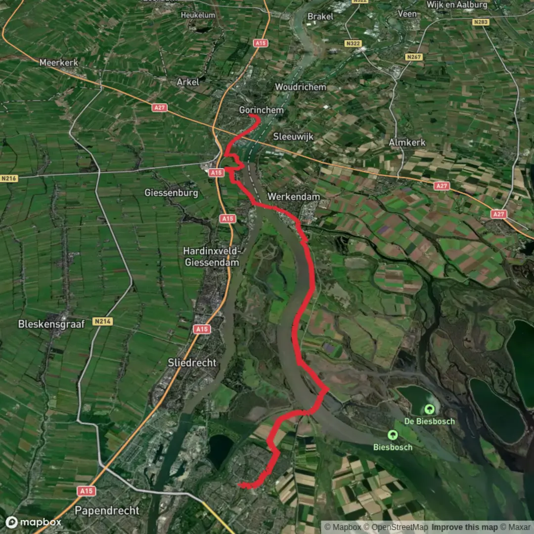
“Follow the Merwede’s dike-top ribbon from Dordrecht to Gorinchem—big skies, barges, and wild wetland edges.”
This is a flat, riverside point‑to‑point walk of about 24 km (15 mi) with roughly 0 m (0 ft) of climbing, following the broad water landscape between Dordrecht and Gorinchem along the Merwede system. Expect long, open dike-top stretches, big skies, constant water views, and a route that feels “wild” in places despite being threaded between towns, ferry links, and working river infrastructure.
Start (nearest landmark/address): Dordrecht Stadspolders railway station, Dudokplein 100, 3315 KE Dordrecht. (treinstationinfo.nl)
Finish (nearest landmark/address): Gorinchem railway station, Stationsplein, Gorinchem. (en.wikipedia.org)
Getting to the start (public transport + car)
- By train: Dordrecht Stadspolders station sits on the MerwedeLingelijn with local trains running between Dordrecht and Gorinchem (and onward toward Geldermalsen). That makes this hike especially convenient as a one‑way walk with a simple rail return. (en.wikipedia.org)
- By car: Navigate to Dudokplein 100, 3315 KE Dordrecht (station address). Parking availability varies by neighborhood; if you’re driving, it’s worth checking local signage and paid-parking rules near the station before committing to a long day. (treinstationinfo.nl)
What the walking feels like underfoot
Most of the day is on paved or hard-packed dike paths, riverside service roads, and multi-use cycling routes—excellent for steady pacing and easy footing, but potentially monotonous if you prefer singletrack. Because the terrain is essentially flat, the main “difficulty” comes from distance, wind exposure, and timing ferry crossings (if your chosen line uses them).
Plan on 4.5–6.5 hours of moving time for most hikers, plus stops for viewpoints, ferries, and food.
Route character and key sections (with planning distances)
0–4 km (0–2.5 mi): Dordrecht’s edge into open waterland
Leaving the Stadspolders area, the urban edges fall away quickly and the landscape opens into waterways, reedbeds, and dike lines. This is where you’ll start noticing how much of the region is engineered around water—straight channels, raised embankments, and controlled inlets.
4–14 km (2.5–8.7 mi): Long dike-top cruising beside the Merwede
This is the “engine room” of the hike: long, level kilometers with wide views across the river corridor. On clear days you’ll see barges and commercial traffic moving steadily; on grey days the same stretch can feel stark and dramatic. Wind is often the biggest factor—if it’s blowing, it can add real effort despite the flat profile.
14–20 km (8.7–12.4 mi): Nature-heavy stretches near the Biesbosch fringe
As you approach the broader wetland influence of National Park De Biesbosch, the scenery becomes more marshy and wildlife-rich. De Biesbosch is known as the largest freshwater tidal area in Europe, with willow flood forests, reedbeds, creeks, and mudflats shaped by river flow and tidal influence. (nationaleparken.nl)
Even if your exact line stays on the dikes rather than deep inside the park, you’ll feel the transition: more birds, more “wetland” vegetation, and more side waters.
20–24 km (12.4–15 mi): Approaching Gorinchem
The final kilometers gradually trade open dike views for the approach into Gorinchem’s built-up edges, ending neatly at Stationsplein by the railway station—ideal for an immediate train connection.
Navigation (use HiiKER)
This is a route where it’s easy to stay generally “right” (follow the river/dike) but still miss a crucial turn, ferry landing, or underpass. Load the route in HiiKER before you start and download it for offline use. Pay special attention to: - Ferry waypoints (landing locations can be slightly offset from where you expect on a map) - Dike transitions (where you leave the crest to pass through a gate, under a bridge, or around a harbor/industrial edge)

Surfaces
Asphalt
Unknown
Grass
Gravel
Paved
Concrete
Comments and Reviews
User comments, reviews and discussions about the Dordrecht Stadspolders to Gorinchem via Merwede, Netherlands.
average rating out of 5
0 rating(s)