Download
3D Flyover
Add to list
More
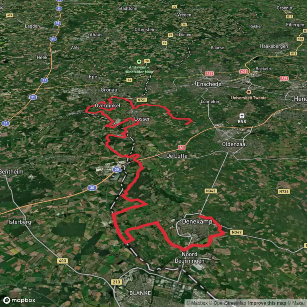
63.8 km
~3 days
153 m
Multi-Day
“A ribbon-flat border ramble of canals, farms and arrow-straight Grenzpfad miles—endurance over elevation.”
This is a long, low-relief border-country walk through the eastern Netherlands and the German frontier zone: mostly flat farmland, canal edges, village lanes, and long straight “Grenzpfad” (border path) segments, stitched together with the Drielandweg (Three-Country Route) feel even though you’re essentially tracking the NL–DE boundary for much of the day. At ~64 km (about 39.8 miles) with roughly 200 m (about 656 ft) of total ascent, the challenge is duration, foot comfort, and staying fueled—not steep climbing.
Getting to the start (Denekamp) + where “near” is
Start area (Denekamp): Denekamp is a village in Twente (Overijssel), close to the German border. A practical “pin” to aim for is Denekamp town center around the St. Nicolaas Church (Sint Nicolaaskerk), near the main square and shops—this is the most obvious landmark for meeting, last-minute supplies, and orienting yourself.
By public transport (from within the Netherlands):
- The nearest larger rail hubs are typically Oldenzaal and Hengelo (regional and intercity connections). From there, you’ll usually continue by regional bus toward Denekamp.
- Plan the exact bus line/times for your date and time window and save the route offline in HiiKER so you’re not dependent on mobile signal in the quieter border stretches.
By car: - Denekamp is straightforward to reach via the Twente road network; parking is usually easiest on the edges of the village center (look for signed public parking near the central amenities). If you’re doing this as a point-to-point, arrange a shuttle or second car at the finish because 64 km is not a casual “out-and-back.”
Finish area (De Snippert): - “De Snippert” is best treated as a named local place/area rather than a major town. In practice, you’ll want to identify it in HiiKER and then anchor your pickup to the nearest signed road junction, café, or bus stop within a short walk. If you tell me the coordinates you’re using for “De Snippert,” I can translate them into the nearest recognizable landmark (village, road, or notable site).
What the route feels like (pace, surfaces, and effort)
Expect a steady, rolling-flat day: the 200 m (656 ft) of gain is spread out in tiny rises—dikes, embankments, gentle undulations, and short ramps over bridges or road overpasses. Underfoot is typically a mix of: - Paved village streets and cycle paths - Hard-packed farm tracks - Grassy or dirt border-path sections that can turn slick after rain - Occasional sandy patches in heath/woodland pockets
For most hikers, a realistic moving pace is 4–5 km/h (2.5–3.1 mph) on the flatter, firmer sections, but overall average drops once you include food stops, navigation checks, and any muddy slowdowns. Many will treat this as a very long day hike or a fast-and-light ultra-walk.
Segment-by-segment expectations (approximate)
Distances are approximate because border-path routing can vary slightly depending on access, seasonal diversions, and which exact Grenzpfad/Drielandweg variants you follow in HiiKER.
0–12 km (0–7.5 mi): Denekamp out into the Twente countryside
Leaving Denekamp, you’ll quickly trade village edges for open agricultural land—pastures, hedgerows, drainage ditches, and long sightlines. This is where you settle into rhythm: - Navigation: lots of intersecting farm lanes can look similar; confirm each turn in HiiKER rather than trusting “it must be that track.” - Water/food: Denekamp is one of your best early resupply points; after that, services can become intermittent depending on the exact line you take.
Wildlife is subtle but present: hares, pheasants, songbirds, and in wetter margins herons and other waterbirds. Early morning and dusk bring the most movement.
12–30 km (7.5–18.6 mi): Grenzpfad character—quiet border tracks and mixed woodland pockets
This middle stretch is where the “border path” identity becomes clearer. You’ll often be walking parallel to the boundary, sometimes with only a ditch, fence line, or thin strip of trees separating countries. Expect: - Long straightaways that are mentally easy but can be hard on feet if you don’t manage hotspots early. - Short wooded sections that provide shade and a different feel underfoot—more roots, leaf litter, and occasional mud. - Small crossings and junctions where signage may be inconsistent; border regions sometimes have multiple local waymark systems layered on top of each other.
Historical context to notice as you go:
This region sits in Twente, a historic borderland shaped by trade routes, shifting jurisdictions, and later by the practical realities of modern borders. Even when the landscape looks purely rural, the border has long influenced:
- Settlement patterns (villages clustered where routes and arable land made sense)
- Customs and commerce (border proximity historically meant tolls, markets, and—at times—smuggling routes)
- Wartime and postwar infrastructure (roads, canals, and administrative boundaries that still guide today’s paths)
You may pass **old boundary markers

Surfaces
Unknown
Asphalt
Grass
Concrete
Sand
Ground
Unpaved
Dirt
Wood
Gravel
Comments and Reviews
User comments, reviews and discussions about the Denekamp to De Snippert via Grenzpfad and Drielandweg, Netherlands.
average rating out of 5
0 rating(s)