Download
3D Flyover
Add to list
More
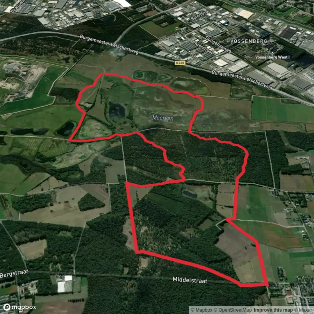
9.2 km
~1 hrs 49 min
0 m
Loop
“Wander tranquil heathlands and ancient paths, where wildflowers, wildlife, and history paint every scene.”
Starting from the outskirts of De Moer, a small village in North Brabant, this 9 km (about 5.6 miles) loop trail offers a gentle, flat walk through some of the most serene landscapes in the Netherlands, with virtually no elevation gain. The trailhead is conveniently located near the intersection of Molenbaan and the Hertogenpad, just a short walk from the village center and close to the well-known Galgenven, a picturesque pond surrounded by heathland.
Getting There
De Moer is easily accessible by public transport. The nearest major city is Tilburg, from which you can take a local bus (such as line 130) to the De Moer, Kerk stop. From there, it’s a short walk to the trailhead. If arriving by car, parking is available near the village church or at the small lot by the Galgenven, just off Molenbaan.
Heathland, Wetlands, and Forests
The route begins by skirting the edge of Galgenven, a tranquil pond that is a haven for waterfowl and dragonflies in spring and summer. The surrounding heathland bursts into color with purple heather in late summer, and the open landscape is dotted with Scots pine and birch trees. The trail then leads into the Moerven, a wetland area that is home to frogs, newts, and a variety of birdlife. Wooden boardwalks may be present in wetter months, making the path accessible year-round.
Historical Significance
The name Galgenven hints at a darker past—“galgen” refers to gallows, and this area was once used for executions in medieval times. The Hertogenpad, part of the route, is a long-distance path named after the Dukes of Brabant, who once ruled this region. Walking here, you’re tracing the footsteps of traders, soldiers, and villagers who have used these paths for centuries.
Landmarks and Navigation
At about 2 km (1.2 miles), you’ll pass a restored windmill, a classic Dutch landmark that’s still operational on certain days. The trail continues along sandy tracks and quiet forest lanes, looping back toward De Moer. Waymarking is clear, but for precise navigation and to explore side trails, the HiiKER app is highly recommended.
Wildlife and Flora
Keep an eye out for roe deer in the early morning or at dusk, and listen for the distinctive call of the Eurasian curlew in spring. The wetlands support rare orchids and carnivorous sundew plants, while the forest edges are alive with butterflies and songbirds.
Trail Conditions and Preparation
With a total elevation gain of less than 5 metres (16 feet), this hike is suitable for all fitness levels. The paths are mostly sandy or gravel, with occasional muddy patches after rain. Sturdy walking shoes are recommended, especially in wetter months. There are no facilities directly on the trail, so bring water and snacks. The village of De Moer offers a few cafés and a bakery for refreshments before or after your walk.
This loop is ideal for a relaxed half-day outing, offering a blend of natural beauty, local history, and easy access from nearby cities.

Surfaces
Sand
Dirt
Ground
Unknown
Grass
Comments and Reviews
User comments, reviews and discussions about the Galgenven and Moerven via Molenbaan and Hertogenpad, Netherlands.
average rating out of 5
0 rating(s)