Download
Preview
Add to list
More
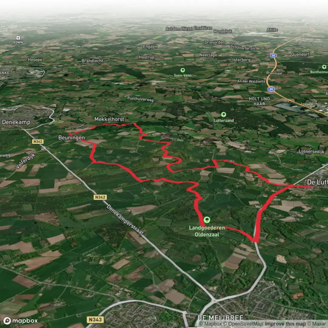
18.5 km
~3 hrs 48 min
68 m
Loop
“A gentle Twente loop of lanes and farm tracks, where hedgerows, ditches, and birdsong meet.”
This easy, mostly flat countryside loop of about 18 km (11.2 mi) with roughly 100 m (330 ft) of total ascent wanders through the Twente region in the eastern Netherlands, close to the German border. Expect a mix of quiet lanes, farm tracks, field-edge paths, and short wooded stretches, with frequent views across open pasture and hedgerows. Underfoot is typically firm (paved cycle paths and compacted farm roads), with occasional softer or muddy sections after rain—especially where paths dip toward ditches and small streams.
Getting to the start (car + public transport)
Because “near” is incomplete, the most practical start area for this loop is usually around De Lutte village center—a reliable landmark is St. Plechelmuskerk (St. Plechelmus Church), Plechelmusplein, De Lutte (a prominent church and square that’s easy to find and commonly used as a meeting point). If your HiiKER track shows a different trailhead, use the nearest pin and match it to the closest village center/parking area.
- By car: De Lutte sits just off the A1/E30 corridor (between Oldenzaal and the German border). Parking is typically easiest around the village center (near the church/square) or at signed public lots by local amenities. Arrive early on weekends if the weather is good—this area is popular with walkers and cyclists.
- By public transport: The nearest major rail hub is usually Oldenzaal (with onward bus connections toward De Lutte/Beuningen depending on the day and timetable). From a bus stop in or near De Lutte, you can walk a short distance to the village-center start. Check the latest bus routing before you go, as rural services can be less frequent outside commuting hours.
If you share the exact lon/lat for the trailhead, I can pinpoint the nearest address or landmark precisely.
What the route feels like underfoot
With only about 100 m (330 ft) of climbing spread across the full distance, the “ups” are gentle: small rises over sandy ridges, subtle undulations through woodland edges, and minor ramps where paths cross over drainage lines or road embankments. The loop is well-suited to steady pacing rather than hill fitness.
- Surface mix: mostly hard-packed farm track and paved cycleway, with intermittent grass or dirt.
- Footwear: light hiking shoes are usually enough; after wet weather, consider something with better mud grip.
- Exposure: open farmland means wind can be a bigger factor than elevation—pack a shell even on mild days.
Landmarks, scenery, and the character of Twente
This corner of Overijssel is classic Twente: a patchwork of meadows, small woods, hedgerows, and farmsteads. You’ll likely pass: - Traditional farm architecture and long, straight field boundaries typical of managed agricultural landscapes. - Wooded pockets that feel noticeably quieter and more sheltered than the open fields. - Drainage ditches and small watercourses—common in Dutch lowland farming areas—often lined with reeds and willows.
As you move between De Lutte and Beuningen, the landscape subtly shifts from village edges to more rural lanes. Beuningen (in this border region) is small and calm, and the route often uses the kind of low-traffic connectors locals use for walking and cycling.
Nature and wildlife to look for
Even in a working agricultural landscape, there’s plenty to notice—especially along hedges, ditch lines, and woodland margins.
- Birdlife: Expect common farmland and wet-edge species—look for lapwings, skylarks, kestrels, and a variety of waterfowl near wetter patches. Early morning and late afternoon are best for activity.
- Mammals: Hares are frequent in open fields; roe deer may appear at woodland edges. You may also spot signs of badgers (tracks, disturbed ground) in quieter wooded sections.
- Plants: Hedgerows can be rich with seasonal change—spring blossoms, summer greens, and autumn berries. In damper spots, reeds and rushes dominate.
Keep dogs leashed where signage requests it—this is both for livestock and ground-nesting birds in open fields.
Navigation and practical planning
This is the kind of loop where many junctions look similar—farm tracks splitting, cycle paths crossing, and field-edge turns that can be easy to miss if you’re chatting or watching the scenery.
- Use HiiKER to follow the track precisely, especially through:
- Village-edge path networks where multiple paved paths run parallel.
- Farm access junctions where the “main-looking” track may not be the correct one.
- Mobile coverage is generally good, but download the route in HiiKER before you set off.
Hazards and things to watch out for
- Cyclists: The Netherlands’ cycle infrastructure is excellent—and busy. On shared paths, walk predictably and keep right where appropriate.
- Farm traffic: Tractors and delivery vehicles can appear quickly on narrow lanes; step onto the verge when needed.
- Mud and slick edges: Ditch-side paths can be slippery, especially after rain or frost.
- Electric fences and livestock: You may pass grazing areas; respect gates and closures, and don’t assume every fence is inactive.
Historical context of the region
This borderland has long been shaped by trade routes, shifting borders, and rural settlement patterns. Twente’s villages developed around agriculture and local craft, and the proximity to Germany has historically influenced language, commerce, and movement

Surfaces
Asphalt
Unknown
Unpaved
Concrete
Gravel
Sand
Paved
Ground
Grass
Wood
Comments and Reviews
User comments, reviews and discussions about the De Hooge Lutte and Beuningen Loop, Netherlands.
average rating out of 5
0 rating(s)