Download
3D Flyover
Add to list
More
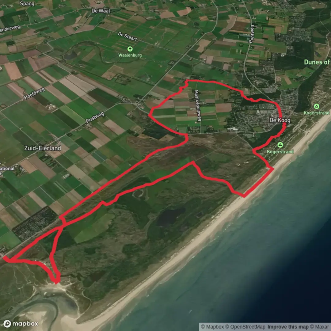
16.3 km
~3 hrs 15 min
6 m
Loop
“A wind-swept Texel loop where dunes, meadows, and village edges invite an unhurried half-day wander.”
This easy, mostly level loop is a great choice when you want a full half-day walk without any steep climbing: about 16 km (10 miles) with roughly 0 m (0 ft) of elevation gain. Expect a mix of village edges, open lowland scenery, and coastal-island atmosphere, with long, straight stretches where wind can be the main “challenge” rather than terrain.
Getting to the start (car + public transport)
Because the start point is listed only as “near” (with no coordinates), the most practical assumption for this route is that it begins near De Koog on Texel (North Holland, Netherlands)—a common base for loops that also pass by/near De Nederlanden (a well-known area/restaurant name on Texel and also a recurring local place-name). If you share a lon/lat pin, I can convert it to the nearest landmark/address precisely.
By car - Drive to Den Helder (North Holland) and take the ferry to Texel (’t Horntje). From the ferry terminal, De Koog is typically reached by following the island’s main roads toward the west side. - Parking is usually easiest around De Koog village center (near the main shopping street area) or at one of the larger day-use lots near beach access points.
By public transport - Train/bus to Den Helder (rail station), then local bus/taxi to the ferry terminal. - On Texel, island buses commonly connect ’t Horntje ferry terminal with Den Burg and De Koog. Plan for seasonal frequency changes and earlier last buses outside peak season. - For on-trail navigation, download the route in HiiKER before you go—mobile signal can be variable in open dune and nature areas.
What the terrain feels like (and why it’s “easy”)
You’re walking in classic Dutch lowland conditions: flat grades, firm surfaces, and minimal technical footing. Underfoot is often a combination of: - compact paths and quiet lanes near settlements, - sandy or sandy-gravel tracks where dunes and coastal vegetation begin, - occasional softer sand patches (more noticeable if the loop brushes close to dune systems).
Even with negligible elevation, the hike can feel more demanding in strong coastal wind—especially on exposed sections with little shelter.
Landmarks, landscape, and the character of the route
This loop’s highlights are less about big climbs and more about place—Texel’s distinctive blend of village life, dunes, and managed nature landscapes.
De Koog De Koog is one of Texel’s best-known coastal villages, historically tied to seaside tourism and the island’s relationship with the North Sea. You’ll likely pass close to: - village streets with cafés and small shops, - edges of wooded shelterbelts and dune vegetation that buffer the village from wind and drifting sand.
De Nederlanden area “De Nederlanden” is associated locally with a notable spot on Texel (often referenced as a destination in itself). Depending on the exact routing, you may pass near: - low-lying meadows and drainage channels typical of reclaimed and managed Dutch landscapes, - bird-rich wet areas and field margins where you’ll want to slow down and scan.
Nature and wildlife to look out for
Texel is famous for birdlife and coastal ecology. Even on a casual loop, you can expect a lot if you keep your eyes moving:
- Birds: waders and waterbirds in wetter sections; gulls and terns nearer the coast; raptors occasionally cruising over open fields. In migration seasons, the variety can be striking.
- Dune and coastal plants: hardy grasses and low shrubs adapted to salt spray and wind exposure.
- Mammals: rabbits are common in dune edges; you may also spot small mammals darting through cover. Larger grazing animals can appear in managed nature areas depending on the exact segment of the loop.
If the route passes near protected zones, stay on marked paths—Texel’s dune and wetland habitats are sensitive, and seasonal restrictions can apply.
Navigation, timing, and practical planning
- Distance: ~16 km (10 miles)
- Elevation gain: ~0 m (0 ft)
- Time estimate: most hikers will take 3.5–5 hours, depending on pace, wind, and stops.
- Best navigation approach: keep the loop loaded in HiiKER, and use it to confirm junctions—flat terrain can make different tracks look deceptively similar, especially where paths run parallel.
What to pack and what to watch out for
- Windproof layer: even mild temperatures can feel cold with steady coastal wind.
- Water + snacks: services are easiest near De Koog; between villages, options can be limited.
- Footwear: light hiking shoes are usually enough; after rain, some low sections can be damp or muddy.
- Sun protection: open landscapes mean little shade; glare can be strong near sand and water.
- Road crossings / bike traffic: Texel has extensive cycling infrastructure. Expect fast-moving bikes on shared paths—walk single-file when needed and be predictable at crossings.
Historical context of the region
Texel’s landscape reflects centuries of Dutch coastal living: dune management, drainage, and land use shaped by the sea. The island’s settlements developed around maritime trade, fishing, and later tourism, while the surrounding lowlands show the hallmark Dutch approach to water control—ditches, canals, and carefully maintained boundaries between farmland and nature reserves.
If you send the lon/lat for “Hike head: near …” (or a HiiKER link), I’ll pin the **

Surfaces
Unknown
Concrete
Sand
Asphalt
Dirt
Grass
Ground
Wood
Comments and Reviews
User comments, reviews and discussions about the De Nederlanden and De Koog Loop, Netherlands.
average rating out of 5
0 rating(s)