Download
3D Flyover
Add to list
More
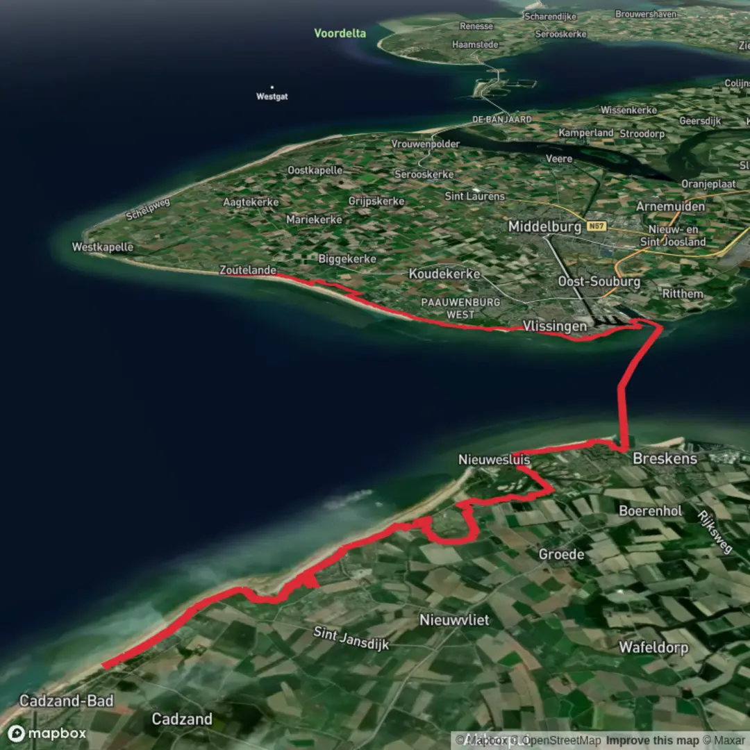
36.9 km
~2 days
106 m
Point-to-Point
“From Cadzand’s dune-edge hamlets to Waterdunen’s engineered wetlands, a wind-swept big-sky coastal ramble.”
This is a long, low-relief coastal walk through Zeelandic Flanders (Zeeuws‑Vlaanderen), linking holiday hamlets and dune edges near Cadzand with the engineered “new nature” of Waterdunen and big-sky views over the Westerschelde shipping lane. At around 37 km / 23 mi with roughly 100 m / 330 ft of total ascent, it’s physically “Easy” by gradient, but it’s still an all-day outing because of distance, wind exposure, and the amount of open terrain.
Where the hike starts and finishes (nearest landmarks)
- Start (“De Brabander”): This name is used locally for the Wijk de Brabander area in/near Cadzand‑Bad (municipality of Sluis, Zeeland)—a cluster of holiday streets just inland of the dunes. (If you’re loading the route in HiiKER, zoom in on Cadzand‑Bad and you should see “Wijk de Brabander” as a neighborhood label on many maps.) (electromaps.com)
- Finish (“Hoge Hilt”): “Hoge Hilt” is best known as De Hoge Hilt beach / parking area on Westkapelseweg in Zoutelande (Walcheren). Note that Zoutelande is across the Westerschelde from Zeeuws‑Vlaanderen, so your route either includes a ferry crossing (most commonly Breskens–Vlissingen) or it’s a multi-stage concept route that assumes transport between banks. (waze.com)
If your intended hike is strictly continuous on foot, confirm in HiiKER whether a ferry segment is included and which one—because that determines your timing and where you’ll actually “touch” the Westerschelde shoreline.
Getting to the start (car + public transport)
By car (simplest): - Drive to Cadzand‑Bad and park near the Wijk de Brabander area (look for public parking signed for the beach/centrum; exact lots vary by season and local restrictions). The area is heavily touristic, so expect paid parking and busy weekends in summer.
By public transport: - The usual approach is train to Vlissingen (or another Zeeland rail hub), then bus connections into Zeeuws‑Vlaanderen via the coastal towns. Zeelandic Flanders is bus-served but less rail-connected, so plan for longer transfers and check the day’s timetable before committing to a 37 km day.
If your route uses the Breskens–Vlissingen ferry, that can also be part of your access plan (arrive at Vlissingen, ferry to Breskens, then bus/taxi onward to Cadzand‑Bad). Ferry services on the Westerschelde are a long-standing part of regional mobility because the estuary isn’t bridged. (britannica.com)
What the terrain feels like over 37 km / 23 mi
You’ll mostly be on: - Dike-top paths and dune-edge tracks (firm, often breezy, big views) - Polder lanes (flat, straight, exposed) - Waterdunen paths including boardwalk/raised sections and well-made access tracks designed for high visitor volume (anwb.nl)
Underfoot is generally easy-going, but after rain the unpaved polder edges and nature-reserve sections can hold water and get slick.
The walk, section by section (with planning distances)
1) De Brabander (Cadzand‑Bad) to the polder edge (approx. 6–10 km / 4–6 mi)
The first hours are about settling into Zeeland’s coastal geometry: straight lines, drainage ditches, and the subtle rise and fall of dikes. You’ll likely pass: - Holiday neighborhoods transitioning quickly into open agricultural land - Dune vegetation on the seaward side (salt-tolerant grasses and scrub) - Long sightlines where wind direction matters more than elevation
What to watch for - Wind exposure: even on a mild forecast, sustained coastal wind can turn a “flat” hike into a slow grind. - Sun + reflection: open dikes and pale sand can feel brighter than expected—bring eye protection and

Surfaces
Unknown
Asphalt
Sand
Concrete
Gravel
Wood
Paved
Grass
Unpaved
Comments and Reviews
User comments, reviews and discussions about the De Brabander to Hoge Hilt via Waterdunen and Westerschelde, Netherlands.
average rating out of 5
0 rating(s)