Download
3D Flyover
Add to list
More
9.3 km
~1 hrs 51 min
0 m
Point-to-Point
“Stroll from Bunnik to Utrecht through lush meadows, historic forts, and riverside orchards, steeped in Dutch charm.”
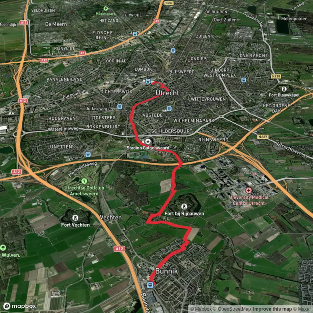
Starting from the charming village of Bunnik, just southeast of Utrecht, this 9 km (about 5.6 miles) route follows the scenic Waterliniepad and Kromme Rijnpad, leading you through a landscape rich in Dutch history and natural beauty, all the way to Utrecht Centraal. With virtually no elevation gain, this easy walk is accessible to most hikers and is perfect for those looking to explore the countryside and riverside paths without strenuous climbs.
Getting There
Bunnik is easily accessible by public transport. The hike begins near Bunnik railway station, which is well-connected by frequent trains from Utrecht Centraal (a journey of about 7 minutes). If arriving by car, parking is available near the station and in the village center. The end point, Utrecht Centraal, is the main train station in Utrecht, making your return journey or onward travel simple and convenient.
Trail Overview and Navigation
The route follows two well-marked long-distance trails: the Waterliniepad and the Kromme Rijnpad. Both are signposted, but for added confidence and real-time navigation, use HiiKER, which provides up-to-date trail maps and waypoints.
Highlights Along the Route
Fort bij Vechten and the New Dutch Waterline
Within the first 2 km (1.2 miles), you’ll pass close to Fort bij Vechten, one of the largest forts of the New Dutch Waterline (Nieuwe Hollandse Waterlinie). This 19th-century defensive line used controlled flooding to protect the heart of the Netherlands. The fort itself is now home to the Waterline Museum, where you can learn about the region’s military history and the ingenious use of water as a defense mechanism.
The Kromme Rijn River and Riverside Meadows
The trail hugs the Kromme Rijn, a meandering river lined with lush meadows, orchards, and poplar trees. In spring and summer, the riverbanks are alive with wildflowers and butterflies, while kingfishers and herons are often spotted along the water’s edge. The area is also known for its fruit farms—look out for farm stands selling fresh cherries and apples in season.
Historic Estates and Castles
Around the halfway mark, you’ll pass several historic estates, including Oud Amelisweerd and Rhijnauwen. These 18th-century country houses are surrounded by ancient woodlands and landscaped parks, offering shaded paths and picnic spots. The Rhijnauwen estate is also home to a popular pancake house, a great place to stop for refreshments.
Approaching Utrecht
As you near Utrecht, the landscape transitions from rural tranquility to the leafy suburbs of the city. The final stretch follows the river into the heart of Utrecht, passing under old stone bridges and alongside historic wharves. The Dom Tower, Utrecht’s iconic Gothic cathedral, comes into view as you approach the city center.
Wildlife and Nature
The Kromme Rijn corridor is a haven for birdlife, including cormorants, grebes, and the occasional stork. The woodlands around Amelisweerd are home to roe deer, foxes, and a variety of songbirds. In autumn, the forests are rich with mushrooms and the changing leaves create a colorful canopy overhead.
Practical Tips
- The entire route is flat, with a total elevation gain of less than 10 feet (0 meters), making it suitable for all fitness levels.
- Surfaces are a mix of paved paths, gravel tracks, and grassy riverbanks; waterproof footwear is recommended after rain.
- Public toilets and cafés are available at Bunnik station, Fort bij Vechten, Rhijnauwen, and throughout Utrecht.
- Dogs are allowed on most sections but must be kept on a leash in nature reserves and near livestock.
This hike offers a unique blend of Dutch history, riverside scenery, and easy access to both countryside and city, making it a rewarding day out for walkers of all ages.

Surfaces
Unknown
Asphalt
Unpaved
Gravel
Cobblestone
Concrete
Ground
Wood
Paved
Comments and Reviews
User comments, reviews and discussions about the Bunnik to Utrecht Centraal via Waterliniepad and Kromme Rijnpad, Netherlands.
average rating out of 5
0 rating(s)