Download
3D Flyover
Add to list
More
17.2 km
~3 hrs 28 min
14 m
Point-to-Point
“Drift from Braamt to Zelhem through hedged farmland, moody lanes, and Slangenburg’s storybook castle pause.”
This easy, mostly level point-to-point walk links the village of Braamt with Zelhem through a classic slice of the eastern Netherlands: quiet lanes, farm country, and a standout cultural landmark at Kasteel Slangenburg. At around 17 km (10.6 miles) with roughly 0 m (0 ft) of climbing, it’s ideal when you want a long, steady day without hills—just keep in mind that “flat” here can still mean muddy paths, slick brickwork, and exposed wind across open fields.
Getting to the start (Braamt) and planning logistics
Start area (nearest landmark): Braamt is a small village just southeast of Doetinchem in Gelderland. A practical place to aim for is Braamt village center near the church and main crossroads (the most obvious, easy-to-find landmark in town). If you’re using HiiKER for the route line, match your start to the first waypoint near the village core so you don’t lose time hunting for a trailhead sign.
By car
- Braamt is easiest approached via Doetinchem and the regional roads that connect the Achterhoek villages. Parking is typically simplest near the village center (look for public parking bays by community facilities or near the church).
- Because this is point-to-point, decide in advance whether you’ll:
- Spot a second car in Zelhem, or
- Use public transport back to Braamt/Doetinchem, or
- Arrange a pickup.
By public transport
- The most reliable strategy is to travel by train/bus to Doetinchem (the main hub nearby), then take a local bus or taxi onward to Braamt.
- From Zelhem, buses commonly connect back toward Doetinchem as well. Check the day’s timetable before you commit—service frequency can drop outside commuter hours and on Sundays/holidays.
Best direction to walk - Braamt → Zelhem works well because it strings the day’s biggest landmark—Kasteel Slangenburg—into the middle of the hike, giving you a natural “halfway highlight” and a good place to pause.
What the route feels like underfoot
Expect a mix of: - Village sidewalks and quiet roads leaving Braamt, - Farm tracks and field-edge paths through the Achterhoek landscape, - Woodland and estate paths as you approach and pass Kasteel Slangenburg, - Then more rural lanes and paths rolling into Zelhem.
Even with minimal elevation change, the walking can vary a lot with weather: - After rain, clay and leaf litter can turn sections slick. - In colder months, shaded woodland stretches can hold frost longer than open fields. - In summer, some straight farm lanes offer little shade, so sun and wind exposure matter more than the profile suggests.
Use HiiKER to keep an eye on small turns where field paths meet lanes—this region often has multiple parallel tracks that look “right” until they don’t.
Landmarks, scenery, and historical context
The Achterhoek (literally “back corner”) is known for its patchwork farmland, hedgerows, and small woods, shaped by centuries of agriculture and estate management. You’ll notice: - Long, straight drainage ditches and canals that keep low-lying ground workable, - Windbreak tree lines and hedges dividing fields, - Traditional farmsteads and quiet hamlets that feel spaced out and calm.
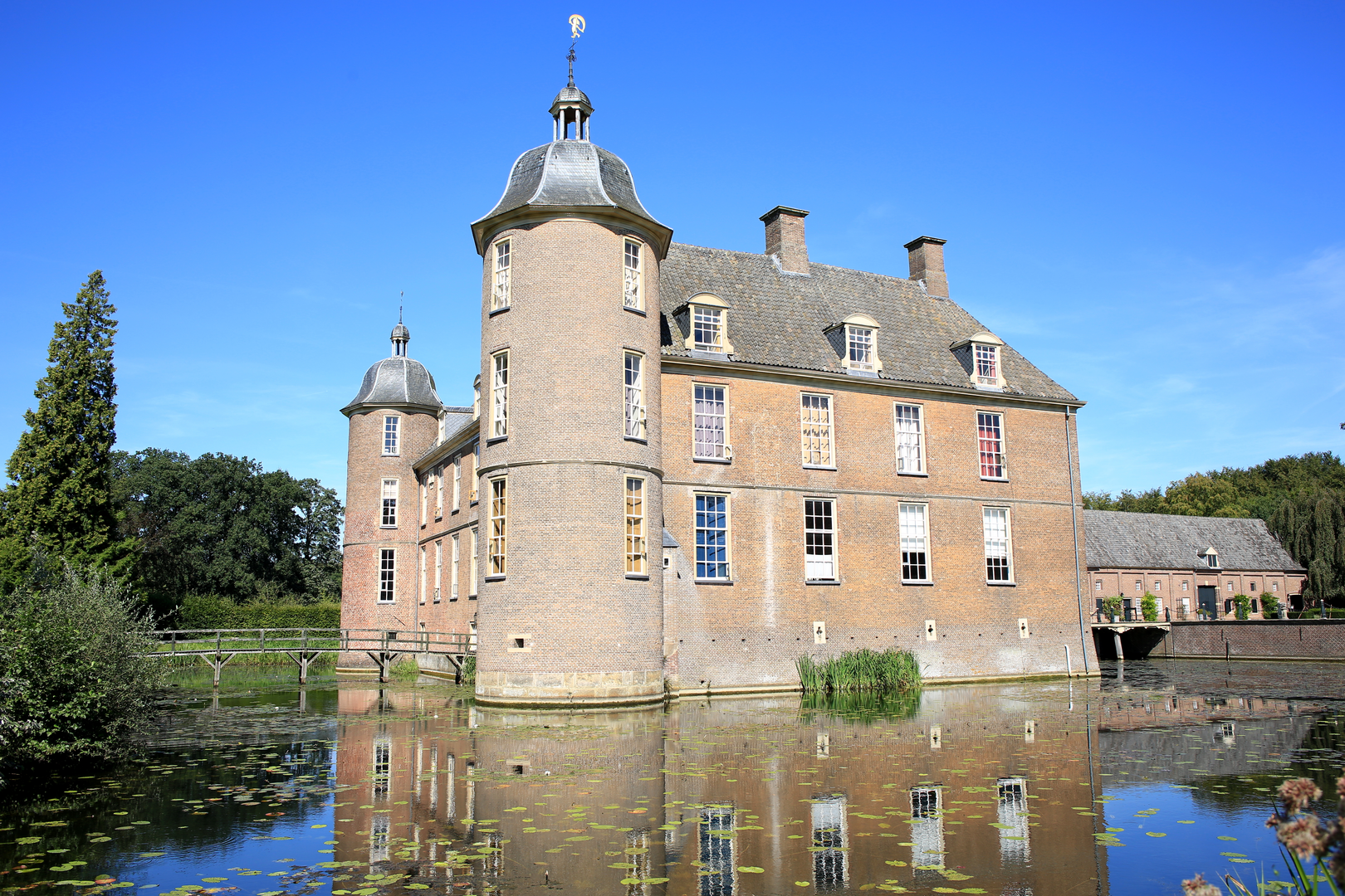
Kasteel Slangenburg (estate and castle grounds)
Kasteel Slangenburg is the signature waypoint: a historic castle and estate set in managed woodland and parkland. The “kasteel” landscape is a hallmark of Gelderland—noble estates that once controlled large tracts of farmland and forest, leaving behind: - Formal approaches and tree-lined drives - Moats/ponds and water features (where present, watch for slippery edges) - A distinct shift in atmosphere from open fields to cooler, shaded woodland
Even if you don’t tour interiors (access varies), the grounds themselves are the draw: a scenic, culturally significant pause that breaks up the day and makes the route feel more varied than the flat stats suggest.
Nature and wildlife to look out for
You’re walking through a mix of agricultural edges and managed woodland, so wildlife tends to appear in transitions—field-to-hedge, hedge-to-wood, and near water.
Common sightings and signs: - Roe deer at dawn/dusk along woodland margins - Hares and rabbits in open fields - Buzzards and kestrels hovering over farmland - Songbirds in hedgerows; in spring, expect a lot of birdsong in the estate woods
Practical cautions: - Ticks can be present in grassy margins and woodland undergrowth in warmer months—long socks and a quick check after the hike help. - Nettles and brambles can encroach on narrower paths in summer. - Around farms, you may encounter electric fencing and livestock—keep to the marked line shown on HiiKER and give animals space.
Distances, pacing, and good break points
For a 17 km (10.6 mile) day on flat terrain, many hikers plan 3.5–5 hours of walking time, then add breaks.
A useful way to break it up: - First 5–7 km (3–4.5 miles): Settling in—village edges and farmland lanes leaving Braamt. - **Middle 4–6 km (2.5–3.7 miles):

Surfaces
Unknown
Asphalt
Sand
Grass
Ground
Concrete
Wood
Comments and Reviews
User comments, reviews and discussions about the Braamt to Zelhem via Kasteel Slangenburg, Netherlands.
average rating out of 5
0 rating(s)