Download
3D Flyover
Add to list
More
19.2 km
~3 hrs 52 min
13 m
Loop
“Stroll past star-shaped forts, sunken bridges, and wildflower-strewn paths in this Dutch countryside adventure.”
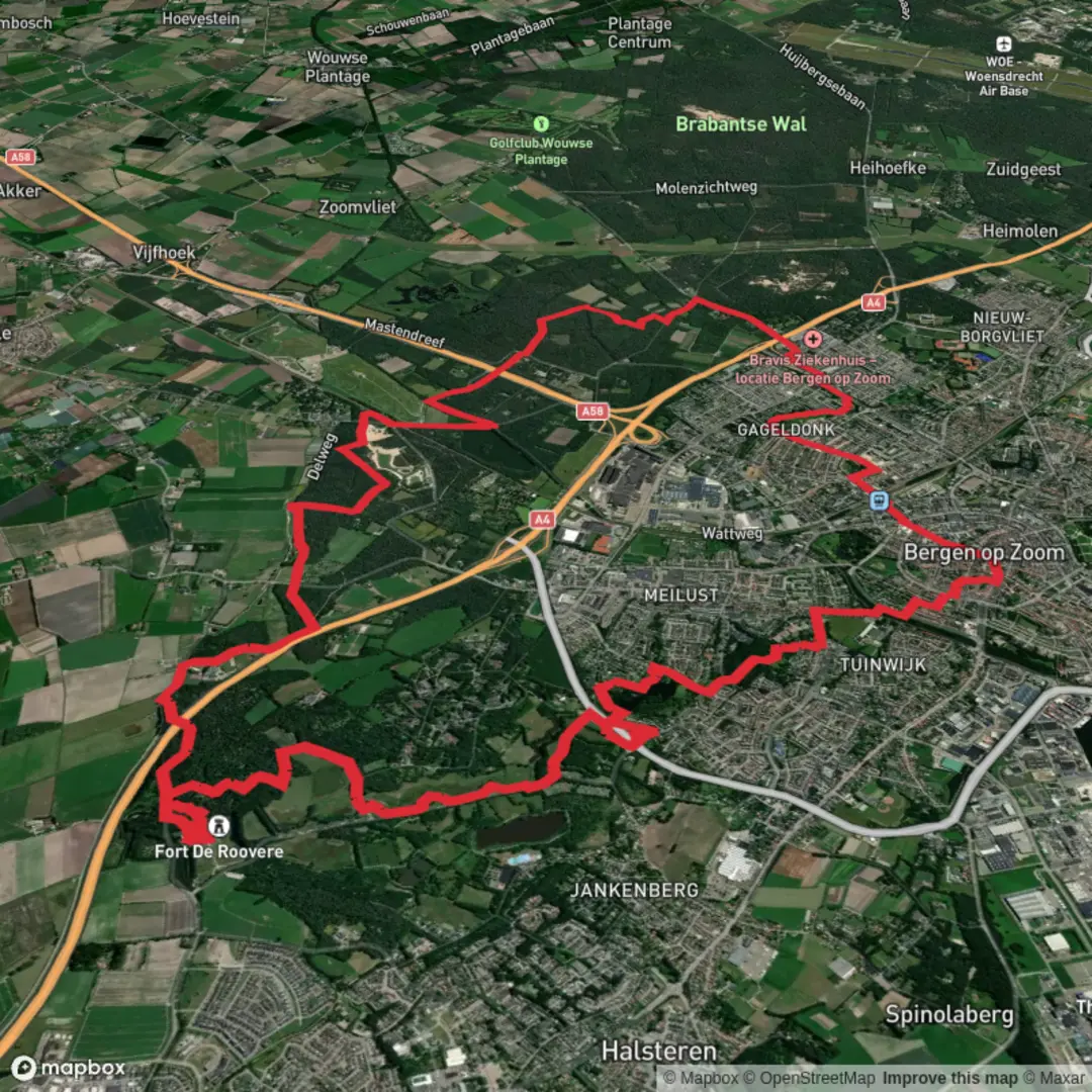
Starting near the historic Fort de Roovere, this 19 km (about 11.8 miles) loop hike through the West Brabant region of the Netherlands offers a gentle, flat walk with virtually no elevation gain, making it accessible for most hikers. The trail weaves together sections of the NS Wandeling De Roovere and the Floris V Pad, providing a blend of natural beauty, cultural history, and unique Dutch landscapes.
Getting There
Fort de Roovere is located just outside Halsteren, a small town northwest of Bergen op Zoom. For those arriving by public transport, take a train to Bergen op Zoom station, then transfer to a local bus (such as line 21 or 22) toward Halsteren. Disembark at the “Halsteren, Fort de Roovere” stop, which is a short walk from the trailhead. If driving, parking is available at the Fort de Roovere visitor lot, located at Schansbaan 8, 4661 PN Halsteren.
Trail Overview and Navigation
The route is well-marked, but for added confidence and real-time navigation, use HiiKER, which provides up-to-date trail maps and waypoints. The path is mostly unpaved, with stretches of woodland, heath, and open polder landscapes. Expect a mix of forest tracks, dike paths, and quiet rural roads.
Highlights and Landmarks
Fort de Roovere and the Mozesbrug (Moses Bridge)
Within the first kilometer, you’ll encounter Fort de Roovere, a star-shaped earthen fortification built in the 17th century as part of the Dutch Water Line, a defensive system that used controlled flooding to protect the region. The fort is famous for the Mozesbrug, a sunken pedestrian bridge that allows you to walk “through” the water without getting wet—a striking architectural feature and a must-see photo spot.
Woodlands and Heaths
Between kilometers 2 and 8 (1.2–5 miles), the trail meanders through mixed woodlands and heath, home to roe deer, foxes, and a variety of birdlife, including woodpeckers and buzzards. In spring and summer, wildflowers and heather add color to the landscape, while autumn brings a carpet of mushrooms and golden leaves.
Viverberg Zuid and Kleine Melanen
Around the halfway mark, you’ll reach the Viverberg Zuid area, a tranquil stretch of forest and open water. The Kleine Melanen, a small lake, is a popular spot for birdwatching—look for herons, grebes, and kingfishers along the reed-lined banks. Benches here offer a peaceful place to rest and enjoy the scenery.
Historic Dikes and Polders
From kilometers 12 to 16 (7.5–10 miles), the route follows ancient dikes that once protected the low-lying farmland from flooding. These raised paths provide sweeping views across the polder landscape, dotted with grazing cattle and traditional Dutch farmhouses. Interpretive signs along the way explain the history of water management in the region.
Practical Information
The entire route is flat, with a total elevation gain of less than 10 meters (33 feet), making it suitable for families and casual walkers. Surfaces can be muddy after rain, so waterproof footwear is recommended. There are several picnic spots and benches along the way, but limited facilities, so bring water and snacks. Public toilets are available at Fort de Roovere and in Halsteren.
The trail is accessible year-round, though spring and autumn offer the most vibrant scenery. Dogs are allowed on leash. For navigation, HiiKER is the recommended tool to ensure you stay on track and make the most of the route’s highlights.

Surfaces
Unknown
Unpaved
Asphalt
Sand
Grass
Cobblestone
Dirt
Gravel
Ground
Paved
Wood
Comments and Reviews
User comments, reviews and discussions about the Kleine Melanen and Viverberg Zuid via GR 5 and Floris V Pad, Netherlands.
average rating out of 5
0 rating(s)