Download
3D Flyover
Add to list
More
38.7 km
~2 days
77 m
Point-to-Point
“Big skies over heather, peat-dark veentjes, and quiet Anloo pines—an all-day, wind-whispered wander.”
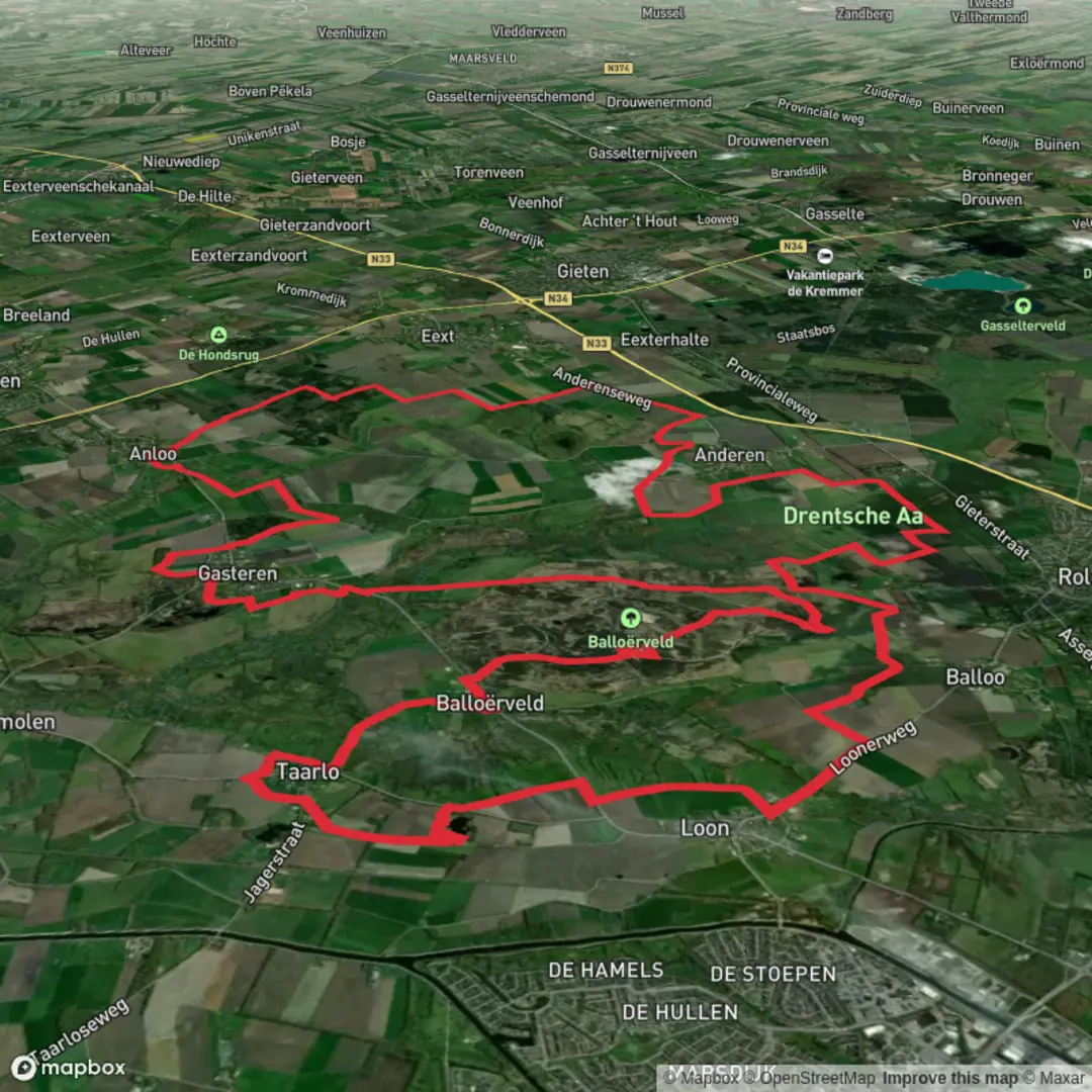
This is a long, low-relief circuit through one of Drenthe’s most characteristic landscapes: open heath and sandy grassland on the Ballooërveld, pockets of wetland around small “veentjes” (peaty ponds), and managed woodland in Boswachterij Anloo. At ~39 km (about 24.2 miles) with only ~100 m (about 330 ft) of total ascent, the challenge is less about climbing and more about time on feet, wind exposure across open moor, and staying oriented where paths braid and signage can be subtle.
Getting to the start (car + public transport)
Because the start point is listed only as “near” (no coordinates provided), the most practical approach is to aim for the Ballooërveld/Anloo area and choose a well-known access point that sits naturally on this loop’s terrain:
- Common, reliable access point: the village of Balloo (near Rolde, Drenthe) and the Ballooërveld trailheads on the edges of the heath. A typical “nearest landmark” to use for navigation is Ballooërveld (heathland) near Balloo/Rolde—you’ll find multiple small parking pull-ins and signed walking entrances around the perimeter.
- By car: Drive toward Rolde and Balloo and park at a designated Ballooërveld access/parking area (look for “Ballooërveld” on local signs). Arrive early on weekends—this is a popular walking area and parking is limited at the smaller trailheads.
- By public transport: The easiest hub is usually Assen (regional rail connections), then a bus toward Rolde. From Rolde, you can walk out to the Ballooërveld edge to join the loop. Check the day’s bus times before committing—service can be less frequent outside peak hours.
If you share the start lon/lat, I can convert it to the nearest recognizable address/landmark and tailor the approach directions precisely.
You’ll want to load the route in HiiKER before you set off. This area has many intersecting sandy tracks, heath paths, and forestry roads that can look similar—HiiKER helps confirm you’re on the intended line, especially where the loop transitions between open heath and woodland.
What the day feels like (distance + pacing)
- Distance: ~39 km / ~24.2 mi
- Elevation gain: ~100 m / ~330 ft
- Time planning: Most hikers will want a full day. Even on “easy” terrain, 39 km is a big outing—plan for breaks, photo stops, and slower sections on sand.
- Underfoot: A mix of firm forest track, sandy paths, and springy heath. After rain, expect soft patches near the veentje/wetland edges and occasional muddy connectors.
Ballooërveld: open heath, sand, and big skies (roughly first third)
The Ballooërveld is the defining landscape early on: broad, open heathland with low vegetation, scattered pines/birches, and sandy soils. Because the terrain is so open, wind can be the main “difficulty multiplier,” especially in cooler months. In summer, the same openness means sun exposure—bring more water than you’d expect for a flat route.
Navigation here can be deceptively tricky: multiple faint lines cross the heath, and some tracks are more “habit paths” than official routes. Use HiiKER to confirm junctions, and don’t be surprised if you see parallel paths forming where people skirt wet spots.
Wildlife and nature to look for - Heathland birds and edge species: listen for calls from scrubby margins and watch for movement low over the heather. - Insect life can be intense in warm months—ticks are a real consideration in heath/rough grass. Long socks and a post-hike check are smart. - You may encounter grazing animals used for conservation management (often sheep or cattle in Dutch heath areas). Give them space, pass calmly, and keep food packed away.
Taarlose Veentje and wet pockets: peat, water edges, and softer ground (middle section)
As you arc toward the Taarlose Veentje area, the landscape subtly shifts: the ground can become darker and damper, with small water bodies and peaty margins. “Veentje” typically indicates a small peat pond or wet depression—these are ecologically important microhabitats and can be surprisingly rich in plant life.
Expect: - Short, softer sections where the path narrows and skirts wet edges. - Seasonal water level changes: after wet periods, the margins can expand and force small detours around puddled ground. - More mosquitoes/gnats in warm, still weather—pack repellent if you’re sensitive.
This is a good place to slow down and watch footing. The route is still “easy” in gradient, but wet roots, slick boards (if present), and muddy pinch points are where slips happen.
Boswachterij Anloo: forestry tracks, shelter, and steady cruising (later section)
Entering Boswachterij Anloo (a managed forest area), you’ll feel the wind drop and the walking often becomes more rhythmic on wider tracks. This section is typically where you can make up time if you’ve been slowed by sand or wet ground earlier.
What to expect: - Long straight forestry roads mixed with smaller, more winding connectors. - Fewer big views, but more shelter and a different soundscape—woodland birds, rustling canopy, and the crunch of needles/sand underfoot. - Junction density can increase: multiple numbered

Surfaces
Unknown
Sand
Asphalt
Ground
Gravel
Concrete
Dirt
Grass
Wood
Comments and Reviews
User comments, reviews and discussions about the Taarlose Veentje, Balloeerveld and Boswachterij Anloo Loop, Netherlands.
average rating out of 5
0 rating(s)