Download
3D Flyover
Add to list
More
13.3 km
~2 hrs 40 min
12 m
Point-to-Point
“Wander from regal Baarn through whispering woods and meadows, where royal history meets tranquil Dutch beauty.”
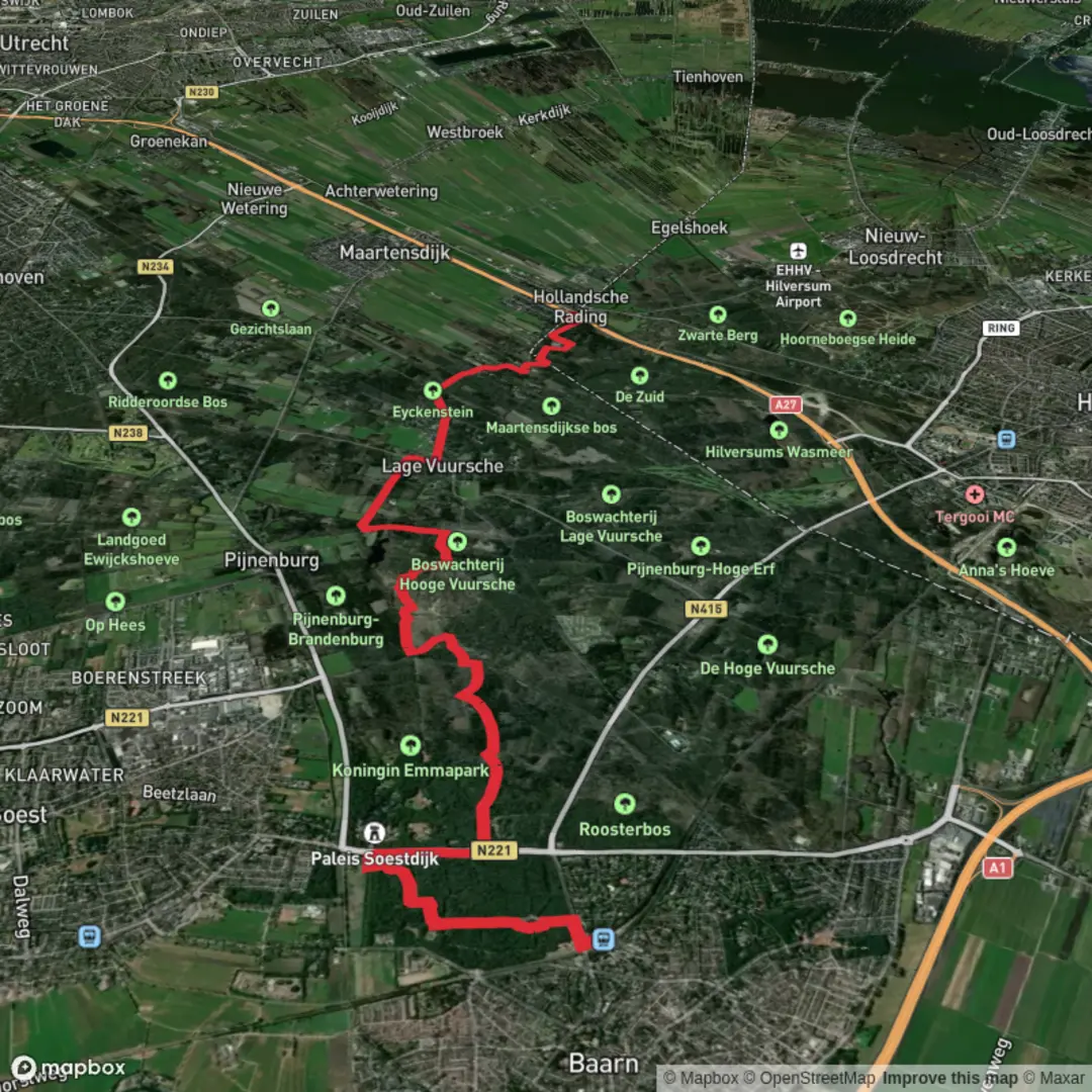
Starting from the charming town of Baarn, this 13 km (about 8 miles) section of the Utrechtpad is a gentle, flat walk with virtually no elevation gain, making it accessible for most hikers. The trailhead is conveniently located near Baarn railway station, which is easily reached by direct train from Amsterdam, Utrecht, or Amersfoort. For those arriving by car, parking is available at or near the station.
Getting Oriented and Setting Off
The route begins in Baarn, a town known for its royal connections and stately architecture. As you leave the station area, you’ll quickly find yourself immersed in the leafy avenues and manicured parks that hint at the area’s aristocratic past. The trail is well-marked, but for added confidence, use HiiKER to follow the Utrechtpad’s official route.
Woodlands, Estates, and Dutch Countryside
After departing Baarn, the path leads you through the lush forests of the Baarnse Bos, a historic woodland once part of the royal Soestdijk Palace estate. The palace itself, located about 1.5 km (1 mile) from the start, is a notable landmark—its white façade glimpsed through the trees. The forest is home to a variety of birdlife, including woodpeckers and songbirds, and in spring, carpets of wildflowers line the trails.
Continuing south, the landscape transitions to open meadows and farmland, typical of the Utrechtse Heuvelrug region. The flat terrain makes for easy walking, and the well-maintained paths are suitable for all fitness levels. At around the halfway point, you’ll pass near the village of Lage Vuursche, famous for its traditional pancake houses and the surrounding stately estates. This is a good spot for a rest or a snack.
Historic Sites and Natural Beauty
The route skirts the edge of the Lage Vuursche woods, an area dotted with ancient beech and oak trees. Keep an eye out for deer and foxes, especially in the quieter stretches. The trail also passes several historic estates, including Drakensteyn Castle, the private residence of Princess Beatrix, though it is not open to the public.
As you approach the final stretch, the landscape opens up again, offering views across the polder fields and waterways that define much of the Dutch countryside. The trail ends at the small station of Hollandsche Rading, which is served by regular trains to Utrecht and Hilversum, making your return journey straightforward.
Planning and Preparation
This hike is best enjoyed year-round, though waterproof footwear is recommended in wetter months due to occasional muddy patches in the forest. The entire route is well-signposted, but carrying a map or using HiiKER is advisable for peace of mind. There are several opportunities to stop for refreshments, particularly in Baarn and Lage Vuursche, but bring water and snacks if you prefer quieter picnic spots along the way.
Wildlife enthusiasts should bring binoculars for birdwatching, and history buffs will appreciate the many plaques and information boards detailing the region’s royal and cultural heritage. The flat, easy terrain and excellent public transport links make this a perfect day hike for families, beginners, or anyone looking to experience the tranquil beauty of the Utrecht region.

Surfaces
Unknown
Sand
Asphalt
Dirt
Unpaved
Gravel
Comments and Reviews
User comments, reviews and discussions about the Baarn to Hallandscha Rading via Utrechtpad, Netherlands.
average rating out of 5
0 rating(s)