Download
Preview
Add to list
More
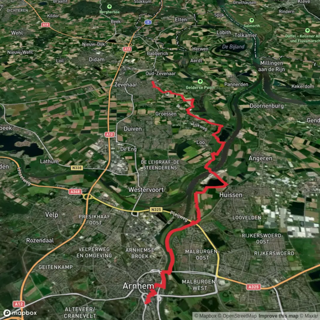
21.5 km
~4 hrs 20 min
18 m
Point-to-Point
“From Arnhem’s storied riverfront to Zevenaar’s big-sky floodplains—flat, easy-going, and sometimes wind-swept.”
This is a mostly flat, low-stress point‑to‑point walk of about 22 km / 13.7 mi with roughly 0 m / 0 ft of climbing, linking Arnhem’s riverfront history with wide, open floodplain landscapes and then on through the Liemers toward Zevenaar. Expect a mix of city sidewalks, riverside paths, dike-top tracks, and paved cycleways—easy underfoot, but potentially windy and exposed once you leave the built-up areas.
Getting to the start (Arnhem) and back from the finish (Zevenaar)
- Start: Arnhem Centraal Station, Stationsplein 38, 6811 KG Arnhem (major rail hub with frequent Dutch intercity and regional connections). (stadindex.nl)
- Finish: Zevenaar Station (rail station in Zevenaar with regular regional services back toward Arnhem and onward connections). (en.wikipedia.org)
- By car: Arnhem Centraal has large parking facilities around the station area; Zevenaar also has station-area parking typical of Dutch commuter towns. If you’re driving, many hikers prefer parking at the finish and taking the train to the start to keep the day simple.
What to expect on the route (with approximate distances)
0.0–2.5 km (0.0–1.6 mi): Arnhem Centraal to the Rhine Leaving Arnhem Centraal, you’ll quickly transition from transport hub to city streets. This early section is ideal for last-minute supplies (water, snacks) and a quick check of your route in HiiKER, because once you commit to the river corridor you’ll likely stay on it for a while. The walking is straightforward and flat, with frequent crossings and cycle traffic—stay alert at bike-priority junctions.
2.5–5.0 km (1.6–3.1 mi): John Frostbrug and the Battle of Arnhem context
You’ll reach the John Frost Bridge (John Frostbrug), the road bridge over the Lower Rhine. (en.wikipedia.org)
This is one of the most significant WWII landmarks in the Netherlands: during Operation Market Garden (September 1944), British airborne troops under John Dutton Frost reached and held the bridge approaches for several days in the Battle of Arnhem, an action later popularized by A Bridge Too Far. (en.wikipedia.org)
Even if you’re not stopping at museums, it’s worth slowing down here—traffic noise and modern infrastructure sit right on top of a place with enormous historical weight.
5.0–12.5 km (3.1–7.8 mi): Out of the city—dikes, floodplains, and big skies Past the bridge area, the route typically trends away from dense streets into more open river landscapes. This is classic Rhine/IJssel-region walking: broad horizons, reedbeds, wet grassland, and seasonal water. Underfoot conditions are usually easy, but after rain you can get slick mud on unpaved floodplain connectors.
Wildlife is often most noticeable here: - Waterfowl (geese, ducks, swans) and other wetland birds are common in the river corridor. - In quieter stretches you may spot herons/egrets and small songbirds in reed margins (especially where marshy edges persist).
12.5–15.5 km (7.8–9.6 mi): Zwanewater / Zwanenbad area (Huissen floodplain waters)
“Zwanewater” in this region is commonly associated with the Zwanenbad / Zwanewater recreation water in the Huissensche Waarden between Huissen and Westervoort. (zwemindex.nl)
A practical navigation anchor here is Badweg, 6851 DP Huissen (near the Zwanenbad/Zwanewater area). (uitzinnig.nl)
This section feels distinctly different from the city: open water, dike lines, and a “river country” atmosphere. It

Surfaces
Unknown
Asphalt
Ground
Concrete
Dirt
Paved
Comments and Reviews
User comments, reviews and discussions about the Arnhem Centraal to Zevenaar via Zwanewater and John Frostbrug, Netherlands.
average rating out of 5
0 rating(s)