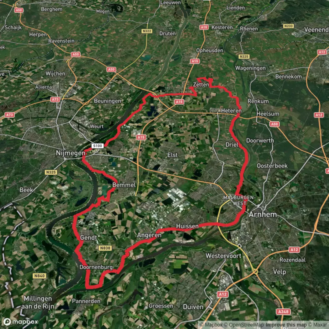
Arnhem, Bemmelsche and Plas van van Wijck via Grote Griel and Nijburgsestraat
Download
Preview
Add to list
More
69.0 km
~3 days
6 m
Multi-Day
“An all-day, ultra-flat riverland loop of big skies, dikes, villages, and wind-swept reflections—best for fit walkers.”
This is a long, very flat lowland loop of roughly 69 km (42.9 miles) with about 0 m (0 ft) of climbing—ideal for strong walkers who want an all-day ramble through river landscapes, dikes, floodplains, and village edges rather than hills. Expect a mix of paved dike-top paths, farm lanes, compacted gravel, and occasional grassy levee tracks that can be slick after rain.
Getting to the start (public transport + car)
Because the start is only given as “near,” the most reliable way to pin it down is to use the first waypoint/trackpoint in HiiKER and match it to the nearest village center or trail access. For this route name, you’ll typically be in the Arnhem–Nijmegen river corridor (Gelderland), where access is straightforward:
- By train/bus: Aim for a major rail hub such as Arnhem Centraal or Nijmegen and connect by local bus toward the smaller river villages and dike roads. From there, it’s usually a short walk to the dike network where routes like this begin.
- By car: Use the nearest village center parking (often signed near a church square, sports fields, or a small marina/dike access). In this region, parking is commonly available near dike access points and recreation areas by the water, but spaces can fill on weekends.
If you share the route’s lon/lat (or a HiiKER link), I can convert the start to the nearest known address or landmark precisely.
What to plan for before you go - Time on feet: 69 km is typically 12–16 hours depending on pace and breaks. Even “easy” terrain becomes demanding at this distance. - Food/water: You’ll pass villages and farms, but opening hours vary. Carry enough for long gaps: at least 2–3 L of water in warm weather, plus electrolytes. - Footing: Flat doesn’t mean effortless—expect repetitive impact on hard surfaces. Cushioned footwear and blister management matter more than ankle support here. - Wind exposure: Dikes are often fully exposed. A calm forecast can still feel harsh along open river corridors. - Navigation: The dike network has many junctions and parallel tracks. Keep HiiKER handy and don’t assume the “obvious” dike is always the correct one.
Terrain and route character (what it feels like underfoot)
You’re moving through classic Dutch riverland: broad floodplains (uiterwaarden), dikes, side channels, reedbeds, and polder edges. The “elevation gain ~0 m” is realistic—any rises are short dike ramps, bridges, or underpasses rather than sustained climbs.
- Dike-top walking: Long straight stretches with big skies and wide views. Great for steady pacing, but mentally monotonous for some—break it up with planned stops.
- Farm lanes and village edges: Expect occasional traffic on narrow roads. Stay alert at bends and where hedges limit visibility.
- Grassy levee sections: These can be muddy and uneven after rain; in summer they can be dry and rutted.
Landmarks and places you’ll notice
The route name points to several local features that shape the day:
- Arnhem area: Arnhem sits near major Rhine branches and historically strategic river crossings. Even when you’re not in the city center, you’ll feel the “river gateway” character—dikes, engineered channels, and managed floodplains.
- Bemmelsche / Bemmel region: This is typical Betuwe/Lingewaard country—orchards, fields, and dike villages. In blossom season (spring), the landscape can be dominated by fruit trees and farm activity.
- Plas van Wijck: “Plas” indicates a lake/pond—often a former clay/sand extraction area or a managed water body. These spots are magnets for waterfowl and are good places to pause, refuel, and check your progress on HiiKER.
- Grote Griel and Nijburgsestraat: These read like local roads/areas rather than a single “monument,” so expect stretches that follow named lanes between villages and dike segments—useful for resupply detours if needed.
Nature and wildlife (what to look out for)
This corridor is shaped by water management and seasonal flooding, so wildlife is often abundant:
- Birdlife: You’re in prime territory for geese, ducks, swans, coots, herons, and cormorants. In reedier sections, listen for warblers; in open fields, watch for buzzards and kestrels hovering.
- Grazers in floodplains: Many Dutch floodplain reserves use cattle or horses for grazing management. Give them space, pass calmly, and don’t get between animals and calves.
- Amphibians and insects: Near still water (plas, ditches), expect frogs and—seasonally—mosquitoes. A head net isn’t usually necessary, but repellent can be welcome on windless evenings.
- Plants and ground conditions: Dike grass can hide uneven ground and holes. Watch footing, especially late in the day when fatigue makes trips more likely.
Historical significance of the region
Even without steep climbs or “mountain drama,” this landscape is historically dense:
- River engineering and dike culture: The Netherlands’ riverlands are a living record of centuries of flood control, land reclamation, and water governance. The d

Surfaces
Asphalt
Unknown
Grass
Concrete
Unpaved
Ground
Comments and Reviews
User comments, reviews and discussions about the Arnhem, Bemmelsche and Plas van van Wijck via Grote Griel and Nijburgsestraat, Netherlands.
average rating out of 5
0 rating(s)