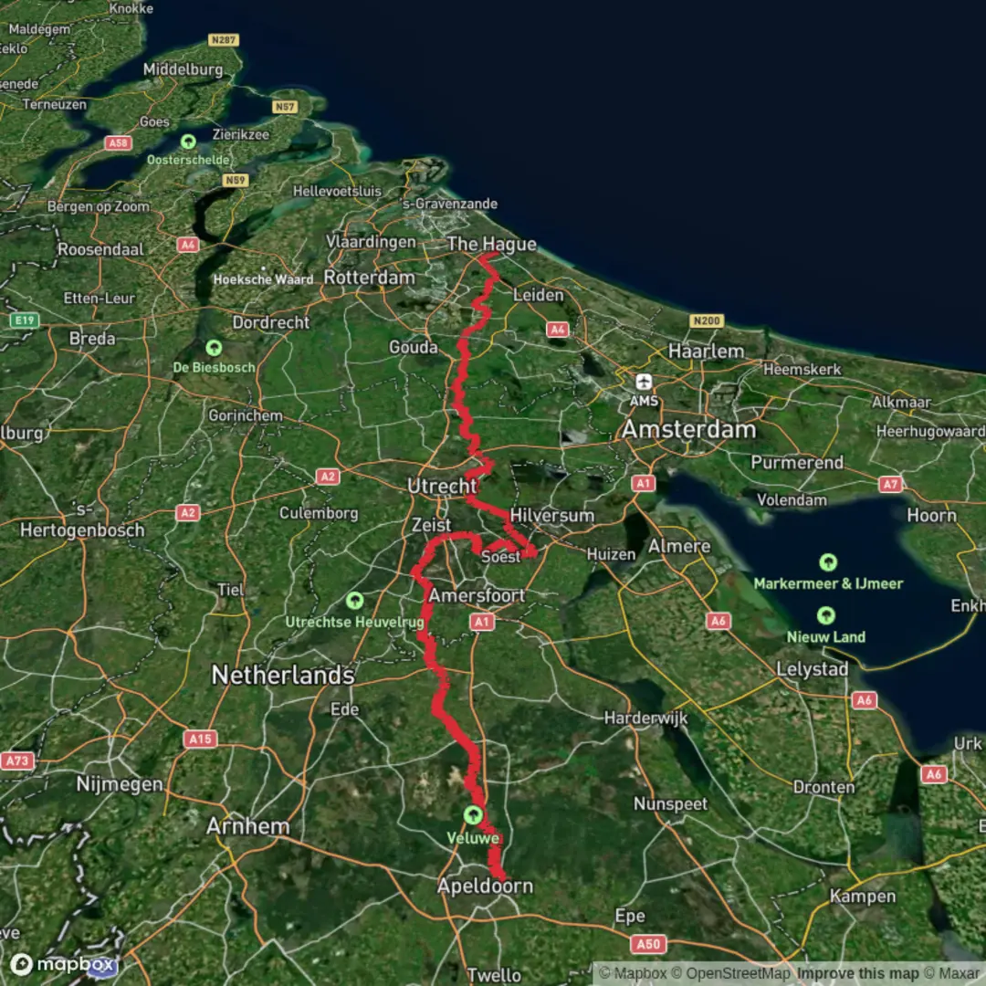
Apeldoorn to The Hague via Soerenseweg, Houtbeekweg, Biltseweg, Vuursche Pad and Duinwaterpad
Download
3D Flyover
Add to list
More
178.4 km
~6 days
123 m
Multi-Day
“A mostly flat ribbon from Veluwe woods to Hague dunes—quiet lanes, shifting landscapes, coastal winds.”
This is a long, mostly flat, cross-country walk from the Veluwe edge at Apeldoorn to the North Sea dunes at The Hague, linking a chain of quiet lanes, forest tracks, and dune paths (Soerenseweg, Houtbeekweg, Biltseweg, Vuursche Pad, Duinwaterpad). At roughly 178 km / 111 mi with about 100 m / 330 ft of total ascent, it’s best planned as a multi-day easy trek where the main challenges are time on feet, wind exposure near the coast, and staying oriented through mixed urban–rural transitions rather than steep climbing.
Getting to the start (Apeldoorn) + where “near” likely means
Because the start is listed only as “near,” the most practical and common start anchor in Apeldoorn is Apeldoorn Centraal railway station (Stationsplein, Apeldoorn)—a major, easy-to-reach hub and a sensible place to begin a long point-to-point hike.
- By train (public transport): Apeldoorn Centraal is well connected by Dutch rail. From the station you can walk a short distance to pick up city greenways and then head toward the Veluwe edge and Soerenseweg.
- By car: Aim for parking near Apeldoorn Centraal (station-area garages) or a park-and-ride on the town edge if you want a quicker exit toward the forest roads. For a one-way hike, many hikers park at the finish (The Hague) and train back, or use luggage transfer/taxi between endpoints.
Route character and pacing
Even with low elevation gain, 178 km / 111 mi is substantial. Typical pacing options: - 4 days: ~44–46 km / 27–29 mi per day (long days; best for strong walkers) - 5 days: ~35–37 km / 22–23 mi per day (comfortable for many) - 6 days: ~29–31 km / 18–19 mi per day (more time for breaks, towns, and weather)
Expect a repeating pattern: forest and heath edges near Apeldoorn → river/lowland corridors and farmland → wooded estates around Utrecht’s ridge → increasingly urban approaches → dune and coastal terrain into The Hague.
Apeldoorn to the Veluwe edge (Soerenseweg): woods, estates, and sandy soils
Leaving Apeldoorn, you’ll quickly trade city streets for greener corridors and then the Veluwe fringe, where the ground often becomes sandy and fast-draining. Soerenseweg is associated with the Apeldoorn–Eerbeek/Laag-Soeren direction, an area known for mixed woodland, estate lanes, and quiet cycling roads.
What to expect underfoot - Firm pavement and compacted gravel early on - Forest tracks that can be soft sand in dry spells - After rain, some shaded sections can hold slick leaf litter even when the rest is dry
Landmarks and regional context - Apeldoorn sits beside the Veluwe, a landscape shaped by ice-age deposits and later managed as hunting forests and estates. - If your line passes near the western side of Apeldoorn, you may be close to the broader cultural landscape around royal and estate grounds (the region is strongly tied to Dutch royal history and planned parklands).
Wildlife - In Veluwe-adjacent woods, it’s common to see signs of roe deer and wild boar (tracks, rooting). Dawn and dusk are the most active times. - Birdlife is rich in mixed forest: woodpeckers, jays, and raptors over clearings.
Planning notes - Carry water leaving town; forest stretches can feel “close to civilization” but still have few taps. - Use HiiKER to keep your line clean where multiple parallel tracks and cycle routes braid together.
Through rural lanes (Houtbeekweg, Biltseweg): farmland edges, canals, and long straight walking
As you transition away from the Veluwe edge, the route names suggest a sequence of local roads and farm lanes (Houtbeekweg, Biltseweg). This middle portion is typically where an “easy” long-distance hike becomes a logistics hike: steady walking, frequent small settlements, and the need to manage food stops and overnight locations.
Terrain and exposure - Predominantly flat, with occasional gentle rises (the total ascent is only ~100 m / 330 ft across the whole route) - More wind exposure across open fields - Long straight segments can feel mentally repetitive—plan short breaks around villages or scenic water crossings
What to look out for - Fast cyclists and local traffic on narrow lanes: stay alert on bends and where verges are minimal. - Agricultural mud: tractor crossings can leave slick patches, especially near field entrances. - Drainage ditches and canals: they’re common in Dutch lowlands; bridges may force short detours—HiiKER helps confirm the correct crossing.
Nature - Expect hedgerows, reed-lined ditches, and wet meadows that attract herons, egrets, and waterfowl. - In spring and early summer, field margins can be lively with insects and songbirds; in wetter pockets, mosquitoes can be noticeable at dusk.
Resupply rhythm - You’ll likely pass frequent towns where bakeries and supermarkets make it easy to restock. - Because the route is long, plan at least one “bigger resupply” day where you top up snacks, blister care, and any rain layers.
Utrecht

Surfaces
Asphalt
Unknown
Concrete
Dirt
Unpaved
Sand
Wood
Paved
Grass
Comments and Reviews
User comments, reviews and discussions about the Apeldoorn to The Hague via Soerenseweg, Houtbeekweg, Biltseweg, Vuursche Pad and Duinwaterpad, Netherlands.
average rating out of 5
0 rating(s)