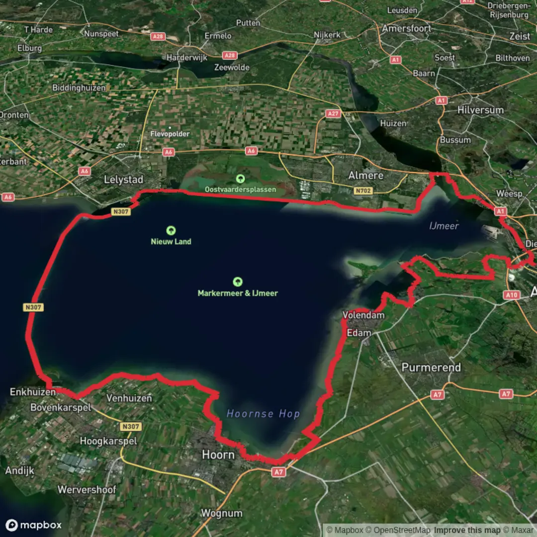
Waterlandse Zeedijk, Maarkerwaarddijk, Oostvaardersdijk and Nesciobrug Loop
Download
3D Flyover
Add to list
More
160.6 km
~6 days
18 m
Multi-Day
“A big-sky dike loop of shimmering waters and wild birds—best for wind-ready, distance-happy walkers.”
This is a long, flat, big-sky loop through the engineered lowlands around Amsterdam and Almere—almost entirely on dikes, sea walls, and multi-use paths, with constant water views and very little elevation change. At ~160 km (about 99 miles) with ~0 m (~0 ft) of climbing, the challenge is less about hills and more about distance, wind exposure, and managing services across long, open stretches.
Because your start point is listed only as “near”, I need one of the following to pin down the hikehead to a real-world landmark/address (and to give accurate transit directions):
- a GPS coordinate (lon/lat), or
- the nearest town/neighborhood (e.g., “near Durgerdam” / “near Muiden” / “near Almere Poort”), or
- the intended “anchor” feature (e.g., “Nesciobrug” / “Markermeer dike” / “Oostvaardersplassen visitor center”).
If you send lon/lat, I’ll convert it to the nearest known landmark/address as requested.
What the route is like (surface, exposure, and pacing)
Expect predominantly paved dike-top paths, asphalt cycleways, and compacted gravel sections—excellent footing, but repetitive and very exposed. With essentially no climbing, your pace will be dictated by: - Wind: headwinds off the Markermeer/IJmeer can be the single biggest factor; plan conservative daily distances if you’re splitting this into 2–4 days. - Sun and shade: shade is limited on the dikes; in warm weather you’ll want sun protection and more water capacity than the “easy” rating suggests. - Monotony and micro-navigation: lots of straight lines and junctions with cycle routes; keep HiiKER handy to avoid drifting onto parallel bike corridors that look identical.
A common way to break ~160 km / 99 mi is: - 3 days: ~53 km / 33 mi per day (very long days, but feasible on flat terrain if you’re conditioned) - 4 days: ~40 km / 25 mi per day (more comfortable, better for enjoying wildlife areas and towns)
Landmarks and scenery you’ll pass
This loop strings together several iconic Dutch water-management landscapes:
- Waterlandse Zeedijk (Waterland Sea Dike): classic North Holland dike scenery—reed-fringed water, wide horizons, and historic villages set behind the dike line. You’ll see the “layered” Dutch landscape: dike crest, drainage canals, and low-lying polders.
- Nesciobrug (Nescio Bridge): a modern, elegant bridge connection between Amsterdam’s eastern edge and Almere. It’s a major visual landmark and a practical crossing that links urban edges to open water landscapes.
- Maarkerwaarddijk / Markermeer dike sections: long, straight, engineered lines with uninterrupted views across Markermeer. These stretches feel remote despite being close to the Randstad.
- Oostvaardersdijk: skirting the edge of the Oostvaardersplassen area, where the feel shifts from “pure infrastructure” to “wild wetland margins,” with big birdlife potential.
Nature and wildlife (what to look for, and when)
Even though this is a heavily engineered region, it’s rich in waterbirds and wetland species.
- Birdlife: expect geese, swans, ducks, grebes, cormorants, and gulls almost anywhere near open water. In migration seasons (spring and autumn), numbers and variety can spike dramatically.
- Raptors: kestrels and other birds of prey often hunt along dike verges and open fields.
- Wetland edges near Oostvaardersplassen: this is where you’re most likely to see dense concentrations of birds and hear constant calls from reedbeds. Keep binoculars accessible rather than buried in your pack.
Practical wildlife etiquette: stay on the path edges where signed, keep noise low near reedbeds, and respect any seasonal closures or fenced areas—these are often in place to protect breeding or sensitive habitat.
Historical significance (why the landscape looks like this)
This route is essentially a tour of Dutch water engineering and land reclamation logic: - Dikes as living infrastructure: many of these dike lines are part of long-running efforts to protect low-lying land from storm surges and manage inland water levels. - Flevoland and the “new land” concept: the broader region around Almere and the Oostvaardersdijk sits within the story of the Netherlands’ major 20th-century reclamation works (polders and planned landscapes). The straightness of roads, canals, and dikes is a direct expression of that planning. - Markermeer/IJmeer system: the waters you’re walking beside are shaped by dams, dikes, and controlled water levels—an engineered inland sea that still functions as a major ecological and recreational zone.
Logistics: food, water, and resupply
On a flat 160 km / 99 mi loop, the key is predictable resupply: - Towns and services: you’ll likely have frequent access near Amsterdam/Almere edges, but some dike stretches can feel service-sparse. Don’t assume cafés will be open year-round on exposed waterfront segments. - Water carry: plan for at least 1.5–2.5 L capacity in mild weather, more in heat or strong wind. Refill whenever you pass a reliable source. - Shelter: windproof layers matter more than insulation most days; even cool temperatures can feel harsh on open dikes.
Hazards and “

Surfaces
Asphalt
Unknown
Concrete
Paved
Grass
Cobblestone
Wood
Dirt
Comments and Reviews
User comments, reviews and discussions about the Waterlandse Zeedijk, Maarkerwaarddijk, Oostvaardersdijk and Nesciobrug Loop, Netherlands.
average rating out of 5
0 rating(s)