Download
3D Flyover
Add to list
More
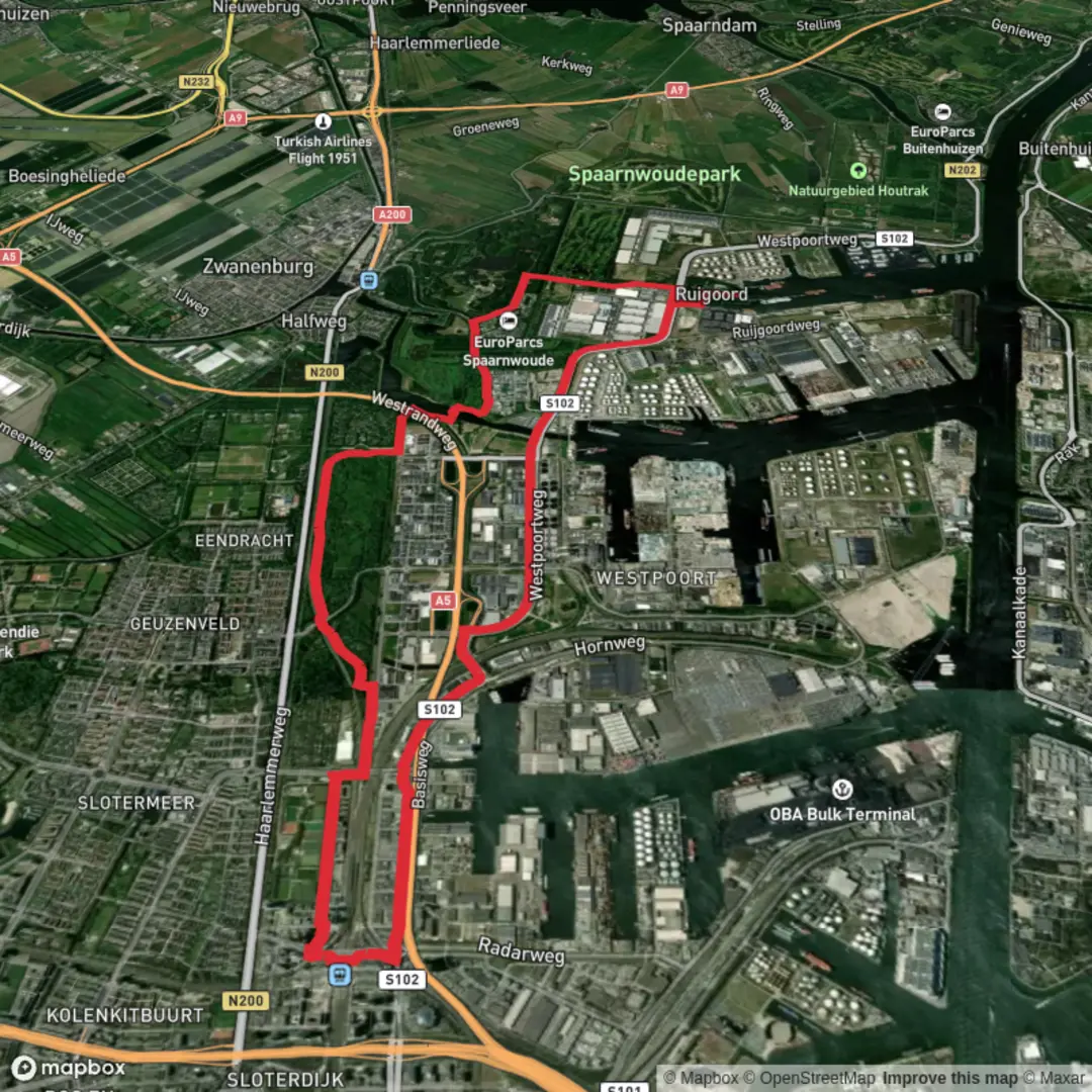
17.9 km
~3 hrs 35 min
7 m
Loop
“Wander from Ruigoord’s vibrant art to wildflower meadows, discovering Amsterdam’s creative spirit and urban wilderness.”
Starting from the outskirts of Amsterdam, the Ruigoord and Lange Bretten Loop is a flat, easy 18 km (about 11.2 miles) circuit with virtually no elevation gain, making it accessible for most walkers and ideal for a leisurely day out. The trailhead is conveniently located near the creative village of Ruigoord, which is easily reached by public transport from Amsterdam Centraal—take a bus towards Ruigoord and disembark at the Ruigoord stop, or drive and park near the village itself.
Getting Oriented and Navigation
For navigation, HiiKER provides detailed maps and waypoints for the entire loop, ensuring you stay on track through the varied landscapes. The route is well-marked, but having HiiKER on your phone is recommended, especially as you traverse the more open stretches of the Bretten.
Ruigoord: Art, History, and Community
The loop begins near Ruigoord, a former island in the IJ Bay that was transformed into a free-spirited artists’ colony in the 1970s. The village is famous for its vibrant murals, creative installations, and the historic church at its center, now used for art events and festivals. Spend a little time exploring the village before heading out—Ruigoord’s unique blend of history and counterculture is a highlight of the walk.
Lange Bretten: Urban Wilderness
Heading east, the trail enters the Lange Bretten, a 10 km (6.2 mile) green corridor that stretches between Amsterdam and Haarlem. This area is a patchwork of wetlands, reed beds, and wildflower meadows, interspersed with canals and small woodlands. The Bretten is a haven for birdlife—look out for herons, swans, and sometimes even kestrels hovering above the fields. In spring and summer, the meadows are alive with butterflies and dragonflies.
Key Landmarks and Features
- At around 4 km (2.5 miles), you’ll cross the Sloterdijk railway lines via a pedestrian bridge, offering panoramic views of the city’s western outskirts and the industrial port area.
- The halfway point brings you to the edge of Spaarnwoude Park, a vast recreational area with picnic spots, small lakes, and grazing Highland cattle. This is a good place to rest and enjoy the open landscape.
- The route loops back through the Bretten, passing several small dikes and drainage canals that are reminders of the region’s centuries-old battle with water. Interpretive signs along the way explain the history of Dutch land reclamation and the ongoing efforts to balance nature and urban development.
Wildlife and Nature
The wetlands and meadows support a surprising diversity of wildlife for such a close-to-city location. In addition to birds, you may spot rabbits, foxes, and—if you’re lucky—roe deer in the quieter stretches. The flora changes with the seasons, from springtime wildflowers to autumn reeds turning golden.
Practical Tips
The entire loop is flat, with well-maintained paths suitable for walking, running, or cycling. There are few facilities directly on the trail, so bring water and snacks. Public toilets and cafes can be found in Ruigoord and at Spaarnwoude Park. Weather can be changeable, so pack a rain jacket and sun protection.
The Ruigoord and Lange Bretten Loop offers a unique blend of art, history, and nature, all within easy reach of Amsterdam. With reliable public transport links and a gentle, scenic route, it’s an excellent choice for anyone seeking a peaceful escape from the city.

Surfaces
Asphalt
Unknown
Concrete
Wood
Comments and Reviews
User comments, reviews and discussions about the Ruigoord and Lange Bretten Loop, Netherlands.
average rating out of 5
0 rating(s)