Download
Preview
Add to list
More
8.7 km
~2 hrs 4 min
201 m
Loop
“A compact Dades loop of red cliffs, kasbah terraces, and maze-like Monkey Fingers spires—adventurous.”
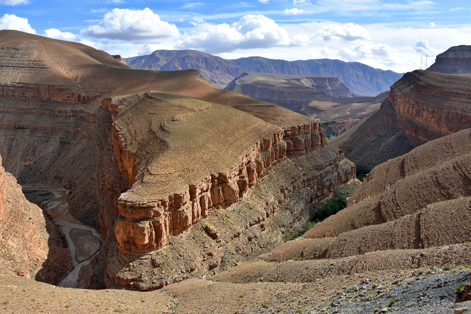
You’re looking at a compact, high-reward loop that mixes classic Dades Gorge scenery—towering red limestone walls, river-cut terraces, and kasbah-dotted villages—with the surreal, wind-sculpted rock formations known as the Monkey Fingers. At roughly 9 km / 5.6 mi with about 200 m / 656 ft of climbing, it’s a Medium outing that feels more adventurous than the numbers suggest because of rough surfaces, route-finding through rock corridors, and a few short, steep pitches.
Important note before planning: your hike details show the start as “near” but don’t include coordinates or a place name. If you share a lon/lat (or the nearest village/hotel), I can pin the start to the nearest known landmark/address and tailor the directions and route notes precisely.
Getting to the start (Dades Gorge area)
Most hikers begin from the Dades Valley road (R704) corridor, commonly staging from Boumalne Dades (Boumalne Dadès) and then driving up-gorge toward the rock formations and small settlements.
By car - From Ouarzazate, the usual approach is via Skoura → Kelaat M’Gouna → Boumalne Dades, then continue into the gorge on the R704. Expect mountain-road driving: narrow lanes, blind bends, occasional rockfall debris, and slow local traffic. - Parking is typically informal: a widened shoulder near a trail entrance, a small pull-off by a café/guesthouse, or near a village edge. Don’t block farm access tracks or the road—locals move by mule, motorbike, and small trucks all day.
By public transport - The practical public-transport hub is Boumalne Dades, reached by intercity buses/grand taxis from larger towns (often via Ouarzazate or Tinghir depending on your route). - From Boumalne Dades into the gorge, options are more limited: grand taxis, arranged transfers through accommodations, or a combination of local rides. Build extra time into your plan—departures can be irregular.
What the loop feels like underfoot
You’ll be on a mix of packed dirt paths, rocky ledges, dry streambed gravel, and short sections of slickrock. After rain, clay-like soils can turn greasy; in dry conditions, the main challenge is loose stones and ankle-twisting rubble in gullies. Trekking poles help on the steeper, looser bits.
Plan for 2.5–4 hours depending on stops, route-finding, and how much time you spend exploring the rock corridors.
Route notes and key landmarks (approximate)
Because “Monkey Fingers” can refer to a cluster of formations and multiple informal paths, use HiiKER to confirm the exact loop line you intend to follow and to stay on the correct side of drainages and ridgelines.
0.0–2.0 km (0.0–1.2 mi): Valley approach and terraces The opening typically threads between small fields and terraces supported by stone walls. You’ll see classic valley agriculture—often fig, walnut, pomegranate, and small vegetable plots—fed by irrigation channels that may be dry depending on season. Expect to pass close to homes: keep voices low, close gates if you open them, and avoid stepping on planted beds.
Elevation gain here is gentle—roughly 50–80 m / 164–262 ft spread out—warming you up without feeling like a climb.
2.0–4.5 km (1.2–2.8 mi): Into the rock—Monkey Fingers formations The terrain tightens into eroded fins, buttresses, and narrow passages where the “fingers” effect becomes obvious: vertical, hand-like spires and rounded towers carved by wind and flash floods. This is the most photogenic section and also where navigation can get messy: - Side paths braid and dead-end into small amphitheaters. - Dry channels can look like trails until they cliff out. - Cairns may exist but aren’t always reliable.
You’ll likely pick up the bulk of the climb here—another 100–130 m / 328–427 ft—often in short, steeper bursts. Watch for loose rock under overhangs and at the base of gullies.
Hazards to look out for (this is what catches people)
- Flash floods: Even if it’s sunny where you are, storms upstream can send water through narrow channels. Avoid lingering in tight gullies if clouds build.
- Rockfall: Common along gorge walls and beneath steep fins—especially after rain or freeze-thaw nights. Don’t stop directly under fractured cliffs.
- Heat and exposure: Shade can be scarce once you’re among the fins. In warm months, start early and carry more water than you think you need.
- Route-finding: The landscape is a maze. Keep HiiKER open, and don’t “just follow footprints”—many lead to viewpoints but not back to the loop.
4.5–7.0 km (2.8–4.3 mi): High traverse and viewpoints Most versions of the loop rise to a slightly higher bench or ridgelet where the view opens back over the Dades Valley—layered red rock, green ribbons of cultivation, and scattered kasbah-style buildings. This is where wind can pick up, and where you’ll feel the “medium” effort if the sun is out.
Underfoot is often broken limestone and compacted dirt, with occasional short scrambles over rock steps. Nothing technical for most hikers, but you’ll want shoes with solid

Surfaces
Unknown
Unpaved
Dirt
Ground
Asphalt
Comments and Reviews
User comments, reviews and discussions about the Dades Gorge and Monkey Fingers Loop, Morocco.
average rating out of 5
0 rating(s)