Download
Preview
Add to list
More
8.8 km
~3 hrs 21 min
956 m
Loop
“From orchard-lined valleys to wind-scoured High Atlas ridges, this steep scramble rewards prepared hikers.”
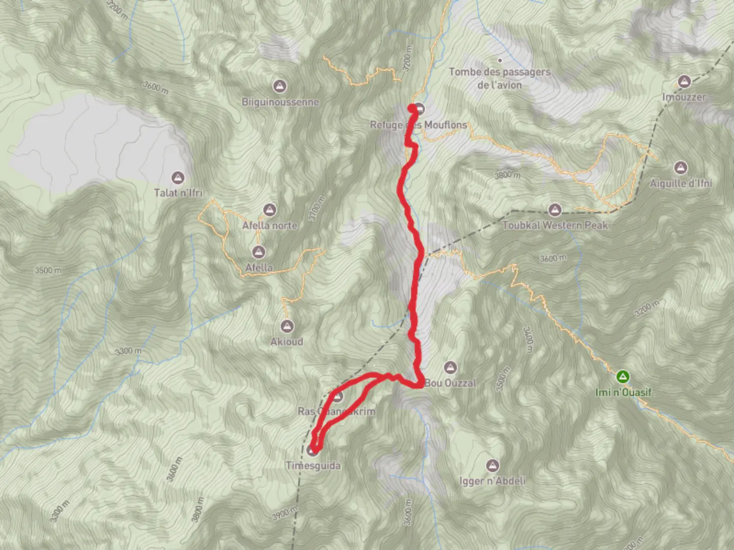
This is a short, steep, high-altitude mountain outing in Morocco’s High Atlas that links a major summit (Ras Ouanoukrim) with the Tizi n’Ougane pass and the Timesguida area. At roughly 9 km (5.6 mi) with about 1,000 m (3,280 ft) of ascent, it’s “Extra Difficult” mainly because of altitude, sustained gradient, loose rock, and fast-changing weather rather than technical climbing—though hands-on scrambling can be required depending on your exact line.
Getting to the start (car + public transport)
Most hikers begin from the Imlil valley (the main trekking hub for Toubkal National Park) and/or the Aroumd (Armed) / Imlil trail network, then connect toward the higher basins and passes. Since your “Hike head” is listed as “near” without a specific coordinate, the most reliable “nearest known landmark” for this route is typically:
- Imlil, Al Haouz Province (common staging point), near the Imlil trailhead area and local gîte zone
- Many parties also stage from Aroumd (Armed) village (a well-known stepping-off point above Imlil)
By car (from Marrakech): - Drive from Marrakech toward Asni, then continue up the mountain road to Imlil. Expect roughly 1.5–2.5 hours depending on traffic and road conditions. Parking is usually informal/paid in Imlil; in busy seasons, arrive early.
By public transport (from Marrakech): - Take a shared taxi or bus toward Asni, then connect by shared taxi to Imlil. This is the standard public-transport chain used by trekkers heading into the High Atlas. Build in extra time for waiting and negotiating seats, especially early morning.
If you share the lon/lat for the exact start point, I can pin it to the nearest named trailhead, village, refuge, or pass and describe the first junctions more precisely.
What the route feels like underfoot
Even at only ~9 km (5.6 mi), the climb is relentless: you’ll gain about 1,000 m (3,280 ft) in a short distance, so expect long stretches where you’re moving slowly and steadily. Surfaces commonly alternate between: - Rocky mule paths and worn trekking lines - Loose scree and rubble on steeper slopes and near passes - Occasional scrambly steps where you’ll use hands for balance (especially if you shortcut switchbacks or take a more direct summit line)
Because this is a high mountain environment, conditions can swing from hot sun to cold wind quickly. Start early to avoid afternoon convection (cloud build-up) and to give yourself margin if the descent is slower than expected.
Key landmarks and terrain changes
Lower approach (valley to high slopes):
You’ll typically begin among terraced fields, walnut and fruit trees, and small hamlets characteristic of Amazigh (Berber) mountain communities. The path often follows established trekking corridors used by hikers and mule traffic. Water channels and irrigation features are common lower down; higher up, the landscape becomes increasingly austere.
Tizi n’Ougane (the pass):
“Tizi” means mountain pass in local usage, and reaching it is often the first major psychological milestone. Passes in this region can funnel wind—expect a noticeable temperature drop and stronger gusts. From here, sightlines open dramatically into adjacent basins and ridgelines, and route-finding becomes more exposed and consequential.
Ras Ouanoukrim area (high ridge / summit zone):
“Ras” commonly refers to a head/peak. Near the top, the trail can fade into multiple boot tracks across rock and scree. The summit zone is typically barren, rocky, and windy, with big views across the High Atlas. If there’s any lingering snow/ice (season-dependent), the final slopes can become much more serious.
Timesguida sector:
Timesguida is associated with the high mountain massif near Toubkal. Depending on your exact line, you may traverse or tag a high point/ridge in the Timesguida area after the pass/summit segment. Expect exposure, loose footing, and a descent that can be punishing on knees due to steep gradients and scree.
Navigation (use HiiKER)
This is not a place to “wing it” if visibility drops. Load the route on HiiKER before you leave signal coverage, and use it to: - Confirm you’re on the correct side of the pass - Avoid drifting onto steeper scree gullies on descent - Identify the safest line back to the valley/trailhead
Carry a backup power source; cold and altitude can drain batteries faster than expected.
Weather, altitude, and timing hazards
- Altitude effects: Even strong hikers can feel headaches, nausea, or unusual fatigue at High Atlas elevations. Pace conservatively, hydrate, and watch for worsening symptoms.
- Wind chill: A sunny start can turn into cold, windy conditions at the pass and summit ridge. Gloves and a warm layer are often needed even when the valley is warm.
- Thunderstorms: In warmer months, afternoon storms can build quickly. Lightning risk is real on ridges and summits—plan to be off the highest ground early.
- Snow/ice (seasonal): If there’s snow on shaded slopes or near the top, traction can become mandatory. A short steep slope with firm

Surfaces
Unknown
Ground
Comments and Reviews
User comments, reviews and discussions about the Ras Ouanoukrim, Tizi n'Ougane and Timesguida, Morocco.
average rating out of 5
0 rating(s)