Download
3D Flyover
Add to list
More
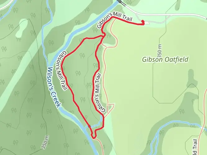
56.6 km
~2 days
113 m
Multi-Day
“The Frisco Highline Trail: a scenic, historic hike through Missouri's heartland.”
Spanning approximately 35 miles (around 57 km) with an elevation gain of around 328 feet (about 100 meters), the Frisco Highline Trail offers an immersive experience through the scenic landscapes near Greene County, Missouri. This point-to-point trail is a journey through both natural beauty and historical significance, providing a medium difficulty rating that caters to both casual walkers and more serious hikers.
Getting to the Trailhead
The trailhead is conveniently located near Springfield, Missouri. For those driving, you can start your journey at the northern trailhead, which is situated just outside of Springfield. If you're using public transportation, Springfield's transit system can bring you close to the trailhead, where you can then use a taxi or a ride-sharing service to reach the starting point.
The Journey Begins
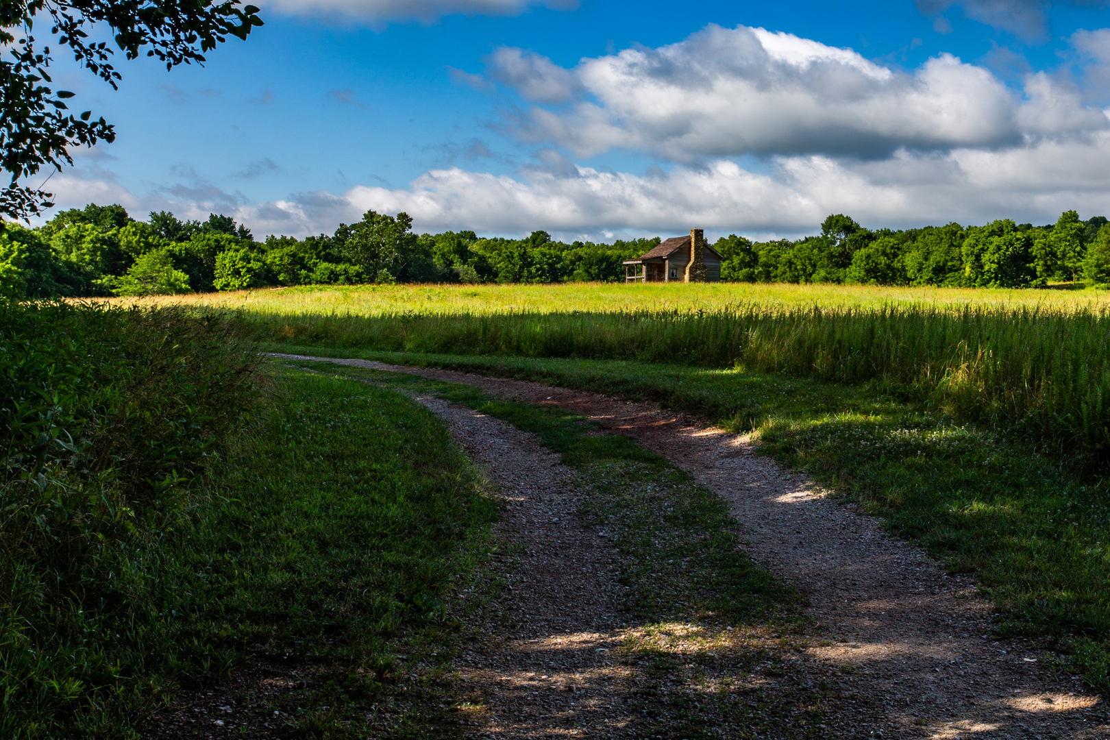
As you embark on the Frisco Highline Trail, you'll find yourself walking along a route that was once a bustling railroad. The trail is well-maintained with a crushed gravel surface, making it suitable for both walking and biking. The first few miles introduce you to the rural outskirts of Springfield, with open fields and the occasional crossing over wooden bridges that offer picturesque views of the surrounding streams and rivers.
Natural Encounters and Landmarks
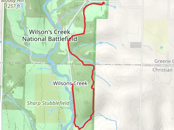
As you progress, the trail will lead you through a variety of landscapes, including dense woodlands, open prairies, and wetlands. These areas are teeming with wildlife, so keep an eye out for deer, wild turkeys, and a diverse array of bird species. Notably, the trail is a part of the Ozark Greenways, a network of recreational trails in southwest Missouri, which adds to its charm and ecological importance.
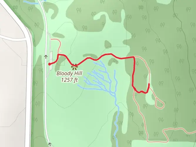
Around the 13-mile mark, you'll encounter the La Petite Gemme Prairie, a restored native prairie that boasts a stunning display of wildflowers during the spring and summer months. Further along, the trail crosses the Polk County line, where you'll find the historic Wishart Trestle. This towering structure is a reminder of the trail's past life as a railroad and offers a panoramic view of the surrounding countryside.
Historical Significance
The Frisco Highline Trail is steeped in history, following the former Burlington Northern railroad corridor. This line played a crucial role during World War II, transporting materials and troops. The trail's name itself is a nod to the St. Louis-San Francisco Railway, commonly known as the Frisco.
Nearing the End
As you approach the southern end of the trail, the landscape begins to change, with more signs of human habitation. The trail ends near Bolivar, Missouri. Here, you can find local eateries to refuel after your journey or arrange for transportation back to Springfield.
Throughout the trail, you'll find several trailheads and access points, which can be useful for planning shorter segments of the hike. For navigation, HiiKER is an excellent tool to keep track of your progress and ensure you stay on the right path.
Remember to pack plenty of water, snacks, and a first-aid kit, as services along the trail are limited. The Frisco Highline Trail is a journey that offers a blend of natural beauty, wildlife encounters, and a glimpse into the region's past, making it a memorable experience for all who traverse its path.

What to expect?
Frequently asked questions
How long is the Frisco Highline Trail and how much climbing does the Frisco Highline Trail have?
The Frisco Highline Trail is about 56.59 km long, or roughly 35 miles, running point to point between Springfield and Bolivar in southwest Missouri. Elevation gain is only about 113 m, so it is a notably flat rail-trail with minimal climbing over the full route.
Where are the main trailheads and parking areas for the Frisco Highline Trail?
The main endpoints for the Frisco Highline Trail are in Springfield and Bolivar. Ozark Greenways lists trail access at 3845 W. Kearney in Springfield and 800 W. Jackson Street in Bolivar, with additional trailheads at Willard, Walnut Grove, and Wishart for shorter out-and-back hikes.
What is the surface like on the Frisco Highline Trail in Missouri?
The Frisco Highline Trail has a mix of paved asphalt and compacted crushed gravel. About 8 miles from Springfield to Willard are paved, another 3 miles are paved inside Bolivar, and the middle section between Willard and Bolivar is mostly compacted crushed gravel, which helps explain the easy rating despite the trail's length.
Are dogs allowed on the Frisco Highline Trail?
Dogs are allowed on the Frisco Highline Trail, but they need to stay on a leash. Ozark Greenways' trail rules also require pet waste to be removed immediately, so the route works best for hikers looking for a long, straightforward rail-trail walk with a leashed dog.
Is the Frisco Highline Trail suitable for beginners or kids?
The Frisco Highline Trail is generally suitable for beginners because it is easy, very gradual, and follows a former railroad corridor. Families often choose shorter sections from trailheads such as Springfield, Willard, or Bolivar rather than tackling the full 56.59 km route in one go.
What are the main landmarks and points of interest on the Frisco Highline Trail?
Notable features on the Frisco Highline Trail include the Sculpture Cruise near Springfield, the Willard trailhead area around mile 6, the Little Sac River stone railroad bridge near mile 22.5, the 317-foot Highline Bridge near mile 26, and La Petite Gemme Prairie near mile 32. The route also passes over 16 former railroad bridges in Polk County.
Are there restrooms on the Frisco Highline Trail?
Restrooms are available at key points rather than all along the corridor. Ozark Greenways notes food, drinks, and restrooms near mile 8, and the Bolivar trailhead at 800 W. Jackson Street has a pavilion, picnic tables, and restrooms, making Bolivar one of the most convenient endpoint facilities on the trail.
Comments and Reviews
User comments, reviews and discussions about the Frisco Highline Trail, Missouri.
4.38
average rating out of 5
16 rating(s)