Download
3D Flyover
Add to list
More
125.7 km
~5 days
462 m
Multi-Day
“Embark on the Mesabi Trail for a scenic hike through Minnesota's rich mining history and diverse landscapes.”
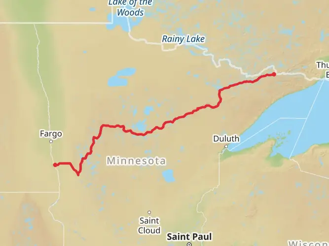
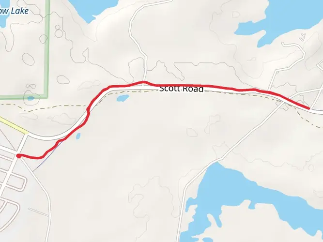
The Mesabi Trail stretches approximately 126 kilometers (about 78 miles) through the picturesque landscapes of Minnesota's Iron Range. With an elevation gain of around 400 meters (approximately 1,312 feet), the trail offers a moderately challenging experience that is accessible to hikers of various skill levels. This point-to-point trail begins near the town of Grand Rapids in St. Louis County and meanders through the heart of Minnesota's mining region before concluding in the city of Ely.
Getting to the Trailhead
To reach the starting point of the Mesabi Trail, hikers can drive to the Itasca County Fairgrounds, located on the outskirts of Grand Rapids. For those relying on public transportation, regional bus services may provide access to Grand Rapids, where you can then take a taxi or a local shuttle to the trailhead.
Navigating the Trail
Hikers can utilize the HiiKER app to navigate the trail, ensuring they stay on the correct path and can pinpoint their location at any time. The app provides detailed maps and trail information that can be invaluable for planning rest stops and identifying nearby amenities.
Landmarks and Scenery
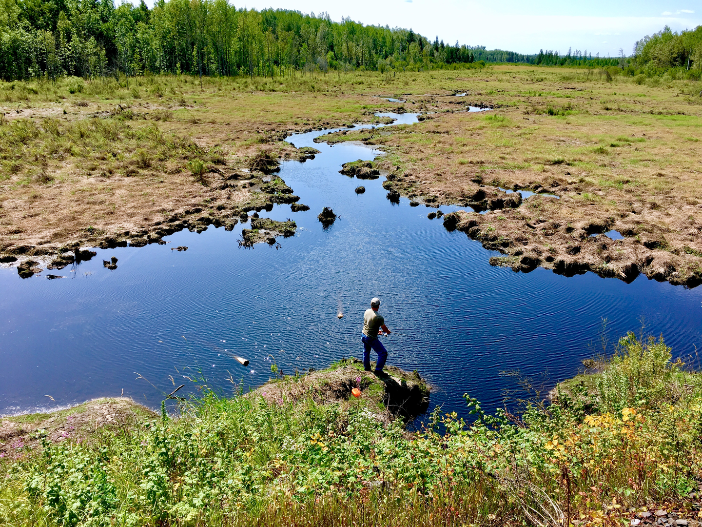
As you embark on the Mesabi Trail, you'll be greeted by a landscape rich in natural beauty and industrial history. The trail passes through a mix of dense forests, serene lakes, and rolling hills, offering a diverse array of scenery. Notable landmarks include the Hull Rust Mahoning Mine View in Hibbing, which provides a panoramic vista of one of the largest open-pit iron mines in the world.
Wildlife and Nature
The trail is home to an abundance of wildlife, including white-tailed deer, black bears, and various bird species. Hikers should be prepared to encounter wildlife and are advised to respect their habitat by keeping a safe distance and not feeding the animals.
Historical Significance
The Mesabi Trail traverses a region steeped in mining history. The Iron Range was a pivotal area for iron ore extraction, which fueled the nation's steel industry and played a crucial role in World War II. Along the trail, hikers will find interpretive signs and historical markers that tell the story of the region's mining heritage.
Trail Conditions and Preparation
The trail surface varies, including paved sections and gravel paths, which can affect the difficulty of the hike. It's recommended that hikers wear sturdy footwear and bring along trekking poles for added stability. Weather conditions can change rapidly, so layered clothing and rain gear are essential. Additionally, hikers should pack sufficient water and snacks, as there are stretches of the trail with limited access to services.
Conclusion
By preparing adequately and respecting the natural and historical significance of the area, hikers can enjoy a memorable experience on the Mesabi Trail. Whether you're seeking a multi-day adventure or a series of day hikes, the trail offers a unique opportunity to explore the beauty and history of Minnesota's Iron Range.

What to expect?
Activity types
Frequently asked questions
How long does it take to complete the Mesabi Trail from Grand Rapids to Ely?
The Mesabi Trail covers 125.74 kilometers, or about 78 miles, from the Grand Rapids area toward Ely. Most hikers break it into several easy days rather than attempting it in one push, especially because it is a multi-day route with only about 462 meters of total elevation gain spread across the full distance.
Where do you start the Mesabi Trail in Grand Rapids, and is there parking at the Mesabi Trail trailhead?
A commonly used western access point for the Mesabi Trail is at the Itasca County Fairgrounds in Grand Rapids. The trail’s official access-point information lists parking at trail access locations, and Grand Rapids is one of the named entry points, making it a practical place to begin a point-to-point trip across the Iron Range.
Is the Mesabi Trail paved, and is the Mesabi Trail good for beginner hikers or walkers?
The Mesabi Trail is known as a paved regional trail across northeastern Minnesota, and its easy rating matches that surface and grade profile well. At 125.74 kilometers with 462 meters of climbing, it is far more approachable than a rugged backcountry route, especially for walkers who want a long-distance outing without steep mountain terrain.
What towns and landmarks does the Mesabi Trail pass near between Grand Rapids and Ely?
The Mesabi Trail runs through Minnesota’s Iron Range and links communities including Grand Rapids, Hibbing, Chisholm, Virginia, and Ely-area access points. One of the best-known landmarks near the route is the Hull Rust Mahoning Mine View in Hibbing, which gives the trail a mix of northern forest scenery and mining history.
When is the best time of year to hike the Mesabi Trail in Minnesota?
The most reliable season for the Mesabi Trail is generally from spring through mid-fall. The trail organization notes that the route is accessible year-round, but the best conditions on this paved corridor are usually from April into mid-October, when snow and ice are less likely to affect long daily mileage.
Are dogs allowed on the Mesabi Trail?
The Mesabi Trail’s published trail-use policies focus on corridor rules and safe use, but a clear, trail-wide dog policy is not prominently stated in the official access and rules pages. Because this is a long paved corridor crossing multiple communities and managed sections, dog access should be confirmed locally before setting out on a full multi-day trip.
Comments and Reviews
User comments, reviews and discussions about the Mesabi Trail, Minnesota.
4.53
average rating out of 5
17 rating(s)