Download
3D Flyover
Add to list
More
21.2 km
~4 hrs 50 min
364 m
Multi-Day
“Explore the Angleworm Trail's enchanting wilderness loop, dotted with scenic overlooks, diverse wildlife, and rich history in Minnesota's Superior National Forest.”
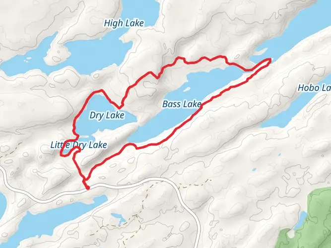
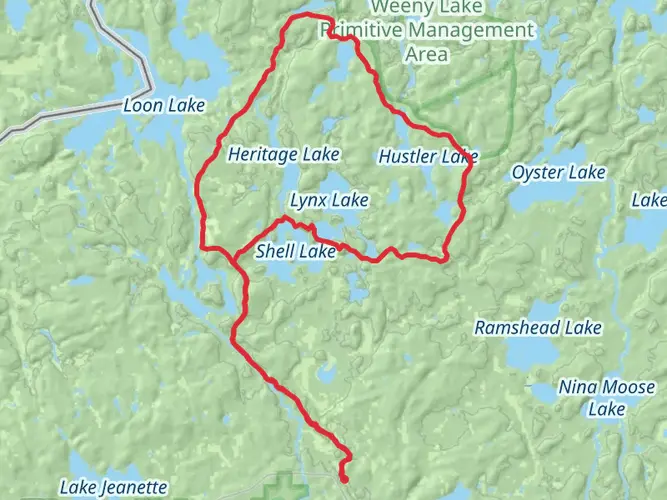
The Angleworm Trail offers a moderately challenging loop that spans approximately 21 kilometers (13 miles) with an elevation gain of around 300 meters (984 feet). Nestled in the Superior National Forest near the Boundary Waters Canoe Area Wilderness, this trail is a hidden gem in St. Louis County, Minnesota, providing hikers with a serene escape into the wilderness.
Getting to the Trailhead To reach the trailhead, you can drive to the entry point located off Echo Trail, a well-maintained gravel road north of Ely, Minnesota. The closest significant landmark is the Echo Trail itself, which is a gateway to numerous trails and entry points into the Boundary Waters Canoe Area. There is no direct public transportation to the trailhead, so access by car is the most feasible option. Parking is available near the trailhead.
Navigating the Trail As you embark on the Angleworm Trail, you'll find that the path is well-marked, but carrying a reliable navigation tool like HiiKER is recommended to stay on track. The trail begins with a gradual ascent through a dense boreal forest, leading you to the first notable landmark, the high ridge overlooking Angleworm Lake. This vantage point, about 3 kilometers (1.9 miles) in, offers a panoramic view of the surrounding wilderness.
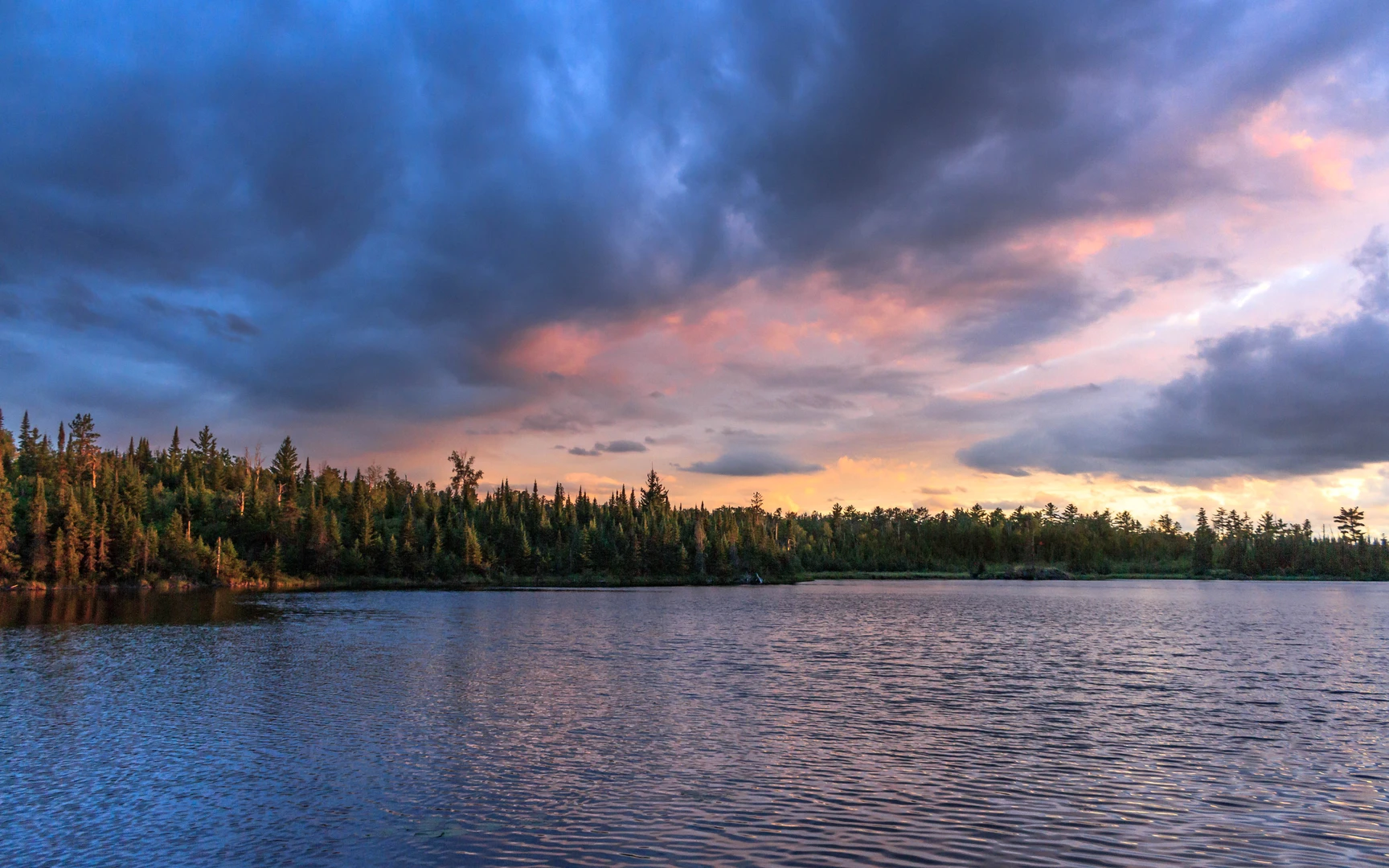
Landmarks and Natural Features Continuing on, the trail meanders along the shoreline of Angleworm Lake, where you can observe beavers at work and may catch a glimpse of the resident moose population. The path then leads you through a series of smaller lakes and bogs, each with its own unique ecosystem. Approximately halfway through the hike, you'll encounter the Whiskey Jack campsite, a perfect spot for an overnight stay or a restful break.
Flora and Fauna The trail is enveloped by a mix of coniferous and deciduous trees, including spruce, pine, and birch, which provide a habitat for a variety of wildlife. Birdwatchers will delight in the opportunity to spot species such as the common loon, northern goshawk, and various woodpeckers. The underbrush is rich with wild berries, and in the fall, the foliage transforms into a vibrant display of colors.
Historical Significance The region around the Angleworm Trail is steeped in history, with the Boundary Waters area having been a vital route for the indigenous peoples and later for fur traders and explorers. The trail itself is a testament to the conservation efforts that have preserved this pristine wilderness for future generations.
Trail Tips The trail's terrain includes rocky outcrops and occasional wet areas, so waterproof hiking boots are recommended. The elevation gain is gradual and spread out over the course of the trail, making it accessible to hikers with a moderate level of fitness. It's important to carry insect repellent, especially during the warmer months, as mosquitoes and flies can be prevalent.
Preparation and Planning Before setting out, ensure you have enough water and food for the duration of the hike, as there are no facilities along the trail. It's also wise to check the weather forecast and prepare for changing conditions, as the area can experience sudden shifts in weather. Lastly, practice Leave No Trace principles to help preserve the beauty and integrity of the trail for others to enjoy.

What to expect?
Activity types
Frequently asked questions
How long does the Angleworm Trail take to hike in St. Louis County, Minnesota?
The Angleworm Trail is a 21.21 km loop, or about 13.2 miles, with roughly 364 m of elevation gain. Most hikers treat it as a full-day hike, while others split it into an overnight because much of the route lies within the Boundary Waters Canoe Area Wilderness and the tread is primitive rather than fast-moving.
Where is the trailhead and parking for the Angleworm Trail near Ely, Minnesota?
The Angleworm Trail trailhead is reached from Ely by driving north on St. Louis County Road 116, the Echo Trail, for about 17 miles, then following the signs to the trailhead. There is a parking lot at the trailhead, making car access the standard way to start this hike.
Do you need a permit for the Angleworm Trail in the Boundary Waters Canoe Area Wilderness?
Yes. Most of the Angleworm Trail is inside the Boundary Waters Canoe Area Wilderness, and permits are required year-round for both day use and overnight travel. Overnight hiking from May 1 through September 30 uses the Angleworm Lake Hiking Trail entry system, while day visitors still need a permit to enter the wilderness.
Is the Angleworm Trail a loop and how difficult is the Angleworm Trail?
The Angleworm Trail is a loop around Angleworm Lake, so it returns to the same trailhead without a shuttle. The route is listed as easy in overall difficulty, but the 21.21 km distance, 364 m of climbing, and primitive wilderness tread mean it still feels like a solid backcountry hike rather than a short walk.
Are there water sources on the Angleworm Trail and can you camp on the Angleworm Trail?
Water is available from lakes along the route, including Angleworm Lake, Home Lake, and Whiskey Jack Lake, with the first dependable lake sources appearing after about 2 miles. There is no potable water in the wilderness, so any lake water needs to be filtered or boiled, and overnight hikers need the proper BWCAW permit before camping.
What landmarks and scenery can hikers expect on the Angleworm Trail?
The Angleworm Trail loops around Angleworm Lake in the Superior National Forest near Ely and passes through classic northwoods terrain in the Boundary Waters region. Notable features include ridge sections above the lake, shoreline stretches, boreal forest, and the remote lake-and-rock landscape that defines this part of northeastern Minnesota.
Comments and Reviews
User comments, reviews and discussions about the Angleworm Trail, Minnesota.
4.5
average rating out of 5
14 rating(s)