Download
3D Flyover
Add to list
More
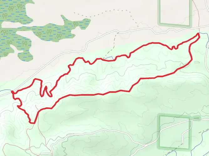
35.0 km
~2 days
565 m
Multi-Day
“Embark on Michigan's enchanting 22-mile Manistee Loop, a diverse trek of river vistas and forested hills.”
The North Country Trail - Manistee River Trail Loop is a captivating journey through the lush forests of Michigan, offering hikers a unique blend of scenic river views, rolling hills, and diverse ecosystems. Spanning approximately 35 kilometers (around 22 miles) with an elevation gain of roughly 500 meters (about 1640 feet), this loop is a medium-difficulty hike that can be completed over several days or enjoyed as a challenging full-day adventure.
Getting to the Trailhead
To reach the trailhead near Wexford County, Michigan, hikers can drive to the Red Bridge River Access site, which serves as a common starting point for the loop. The site is accessible via Coates Highway, branching off from the main highway in the area. For those relying on public transportation, options are limited, but regional bus services may offer routes close to the area, from where a taxi or ride-share service can be used to reach the trailhead.
The Hike Itself
Embarking on the trail, hikers will traverse a variety of terrains, including dense hardwood forests, pine plantations, and high bluffs overlooking the Manistee River. The trail is well-marked, but carrying a navigation tool like HiiKER is advisable to keep track of progress and waypoints.
The loop can be tackled in either direction, but many choose to start on the North Country Trail (NCT) portion, which meanders along the high banks of the Manistee River, providing stunning panoramic views. This section is also where most of the elevation gain occurs, as the trail ascends and descends the rolling hills.
Landmarks and Scenery
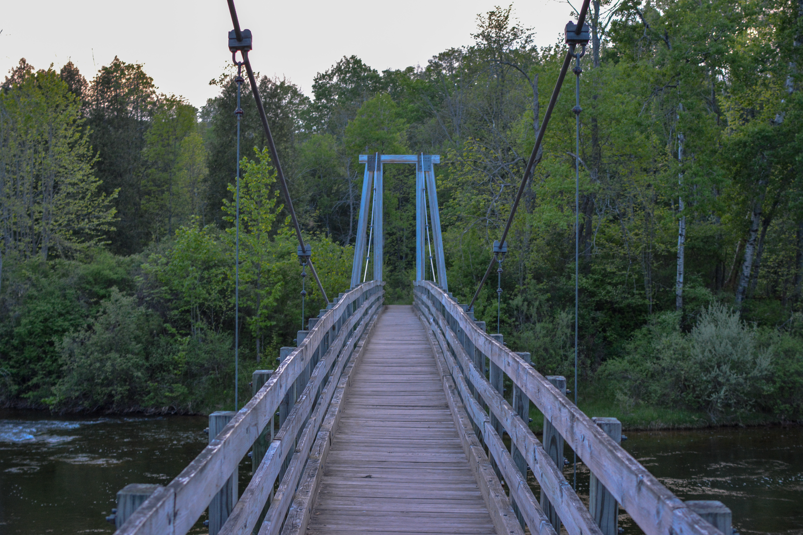
One of the highlights of the hike is the suspension bridge over the Manistee River, located approximately 10 kilometers (6 miles) from the Red Bridge River Access. This bridge offers a picturesque spot for a rest and photo opportunities. Further along, the NCT intersects with the Manistee River Trail, marking the halfway point and the start of the loop back towards the trailhead.
The Manistee River Trail segment hugs the river's edge more closely, allowing for easier access to water and numerous spots to filter and replenish supplies. Hikers will encounter several dispersed camping sites along this stretch, perfect for those who wish to break the hike into a multi-day trek.
Flora, Fauna, and Historical Significance
The trail is rich in biodiversity, with opportunities to spot wildlife such as white-tailed deer, beavers, and a variety of bird species. The changing seasons bring a dynamic display of wildflowers in the spring and a tapestry of fall colors in the autumn.
The Manistee River region holds historical significance as well, with the river itself being a critical waterway for transportation and logging in the 19th century. The surrounding forests have regrown since the logging era, but remnants of old logging roads and historical markers can be found along the trail.
Preparation and Planning
Hikers should come prepared with adequate supplies, including water, food, and layers for changing weather conditions. The trail is accessible year-round, but spring and fall are particularly popular due to the mild weather and natural beauty. Always check local conditions before setting out, as the trail can become muddy or snow-covered depending on the season.
In conclusion, the North Country Trail - Manistee River Trail Loop is a must-hike for those seeking a true Michigan wilderness experience. With its moderate difficulty, it's accessible to hikers with some experience and offers a rewarding journey through one of the state's most beautiful landscapes.

What to expect?
Activity types
Frequently asked questions
How long does the North Country Trail - Manistee River Trail Loop take to hike?
The North Country Trail - Manistee River Trail Loop is 35.04 km, or about 21.8 miles, with 565 m of climbing. Strong hikers sometimes complete it in a long day, but it is more commonly done as a 2-day backpacking loop so there is time for the river section, bluff views, and camp stops near Red Bridge or Seaton Creek.
Where do hikers usually start the North Country Trail - Manistee River Trail Loop?
Common starting points for the North Country Trail - Manistee River Trail Loop are Red Bridge River Access and Seaton Creek on the Manistee River Trail side, plus the Marilla and Upper River Road trailheads on the North Country Trail side. Red Bridge is one of the most popular starts because it has parking and direct access to the loop connection points.
Is the North Country Trail - Manistee River Trail Loop a true loop and can it be hiked in either direction?
Yes. The North Country Trail - Manistee River Trail Loop links the Manistee River Trail with a section of the North Country National Scenic Trail to form a full circuit of roughly 35 km. It can be hiked clockwise or counterclockwise, though many hikers start at Red Bridge and take the North Country Trail side first before returning on the river side.
Are there campsites on the North Country Trail - Manistee River Trail Loop?
Yes. Camping is one of the main reasons hikers turn the North Country Trail - Manistee River Trail Loop into an overnight trip. The Forest Service lists Seaton Creek Campground, primitive camping along the Manistee River corridor, and camping near Red Bridge, with Red Bridge noted for walk-in sites and seasonal drinking water nearby.
Is water easy to find on the North Country Trail - Manistee River Trail Loop?
Water access is uneven on the North Country Trail - Manistee River Trail Loop. The Manistee River Trail side has frequent access to the river and creeks, but the North Country Trail section from Red Bridge toward Eddington Creek is known for having little or no easy water access. Carrying enough water for the ridge and bluff section is important.
What are the main scenic highlights on the North Country Trail - Manistee River Trail Loop?
The best-known highlights on the North Country Trail - Manistee River Trail Loop are the high bluffs above the Manistee River, long forested ridgelines, and the river corridor itself. The route is also known for the large pedestrian suspension bridge that links the two trail systems, making the loop one of the most recognizable backpacking routes in this part of Michigan.
What is the best time of year to hike the North Country Trail - Manistee River Trail Loop?
The North Country Trail - Manistee River Trail Loop is most popular from late spring through fall, when the river access points, campgrounds, and seasonal water sources are generally easier to use. Summer brings the fullest camping season, while fall is especially popular for color on the hardwood ridges above the Manistee River.
Comments and Reviews
User comments, reviews and discussions about the North Country Trail - Manistee River Trail Loop, Michigan.
4.58
average rating out of 5
12 rating(s)