Download
3D Flyover
Add to list
More
151.3 km
~6 days
363 m
Multi-Day
“The White Pine Trail weaves through Michigan's history and nature, from Grand Rapids to Cadillac.”
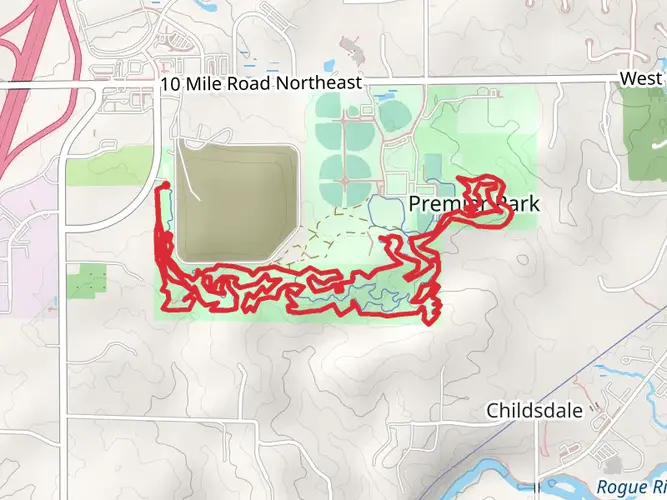
Spanning approximately 94 miles (151 kilometers) with an elevation gain of around 984 feet (300 meters), the White Pine Trail offers an accessible and scenic journey through the heart of Michigan. This point-to-point trail begins near the vibrant city of Grand Rapids, in Kent County, and stretches northward to Cadillac, traversing a variety of landscapes from urban areas to serene natural settings.
Getting to the Trailhead
To reach the starting point of the White Pine Trail, hikers can drive to the southern terminus located just outside of Grand Rapids. For those relying on public transportation, the city's bus system can bring you close to the trailhead, where you may need to walk a short distance or take a taxi to reach the exact starting location.
Navigating the Trail
Hikers can utilize the HiiKER app for detailed maps and navigation assistance throughout their journey on the White Pine Trail. The app provides real-time location tracking and trail information, ensuring that even those new to the trail can hike with confidence.
Trail Experience and Landmarks
The trail, which follows the path of the former Grand Rapids and Indiana Railroad, is a testament to Michigan's rich history in the timber industry and the subsequent development of the railroad. As you embark on the White Pine Trail, you'll notice the flat to gently rolling terrain, making it an easy hike suitable for all skill levels.
The trail is well-maintained with a crushed limestone and asphalt surface, ideal for both walking and biking. Along the route, you'll pass through small towns, farmlands, and wetlands, offering a diverse ecological experience. The Rogue River State Game Area is one of the natural highlights, providing a habitat for a variety of wildlife, including deer, beavers, and numerous bird species.
Approximately halfway through the trail, near the town of Big Rapids, hikers will find the highest point with modest elevation gain. This area offers a panoramic view of the surrounding landscape, particularly stunning during the fall when the foliage is ablaze with color.
Flora and Fauna
The White Pine Trail is enveloped by a mix of hardwood forests and evergreen stands, including the trail's namesake white pines. These towering trees are a remnant of Michigan's once vast pine forests and serve as a living monument to the state's natural heritage.
Historical Significance
The trail's route is not only a journey through nature but also a passage through time. The towns along the trail, such as Rockford and Cedar Springs, provide historical context with their charming downtowns and museums, showcasing the area's transformation from a logging hub to a recreational haven.
Preparation and Planning
Before setting out, hikers should prepare for the changing weather conditions of Michigan, with layers of clothing and rain gear being essential. There are numerous access points and rest stops along the trail, allowing for flexible planning, whether you're interested in a multi-day trek or a series of day hikes.
Water and food supplies can be replenished in the towns along the trail, but it's wise to carry enough to last between these points. Additionally, while the trail is easy to navigate, carrying a map or using the HiiKER app will help in planning your stops and overnight stays.
Conclusion
The White Pine Trail offers a unique blend of natural beauty, historical exploration, and community connection. Its gentle terrain and well-marked path make it an excellent choice for hikers of all ages and abilities looking to experience the heart of Michigan.

What to expect?
Activity types
Frequently asked questions
How long is the White Pine Trail and where does the White Pine Trail start and end?
The White Pine Trail is about 151.34 kilometers, or roughly 94 miles, long. It runs north from the Grand Rapids area in Kent County to Cadillac, following the former Grand Rapids and Indiana Railroad corridor through west-central Michigan.
Is the White Pine Trail paved the whole way from Grand Rapids to Cadillac?
The White Pine Trail is now widely described as fully paved from the Grand Rapids area to Cadillac, making it one of Michigan’s longest paved rail-trails. Older descriptions mention crushed limestone and hard-pack sections, but current state park and trail-group information identifies the route as a paved 92-mile corridor.
Where can you park for the White Pine Trail in Kent County, Michigan?
In Kent County, common access parking for the White Pine Trail includes Lamoreaux Park in Walker, near the West River Drive and North Park Street area. Additional parking is available at several signed trailheads farther north along the corridor, and the full trail is commonly described as having around 19 trailheads between the Grand Rapids area and Cadillac.
Is the White Pine Trail easy enough for beginners, kids, or a first multi-day hike?
The White Pine Trail is generally a strong option for beginners because the route is long but not steep, with only about 363 meters of elevation gain across 151.34 kilometers. Its rail-trail grade keeps climbs gentle, and the easy rating makes shorter family-friendly day sections in Kent County especially manageable.
Can dogs go on the White Pine Trail in Michigan?
Dogs are commonly allowed on Michigan state trails such as the White Pine Trail, but they should be kept under control and leashed where required. Because the route passes through multiple towns, parks, and road crossings between Kent County and Cadillac, checking local posted rules at each trailhead is sensible before setting out.
What towns and landmarks does the White Pine Trail pass through?
The White Pine Trail links the Grand Rapids area with Cadillac and passes through communities including Comstock Park, Cedar Springs, Howard City, Big Rapids, Reed City, and Leroy. One of the best-known landmarks on the route is Reed City, where the White Pine Trail meets the Pere Marquette State Trail.
Are there any closures or detours on the White Pine Trail to know about?
Yes. A state park notice reports that a section of the Fred Meijer White Pine Trail State Park between the Mecosta County Parks office and 207th Avenue in Paris is currently closed for construction. On a trail this long, temporary work zones and local detours can affect individual segments even when the rest of the route remains open.
Comments and Reviews
User comments, reviews and discussions about the White Pine Trail, Michigan.
4.64
average rating out of 5
11 rating(s)