Download
3D Flyover
Add to list
More
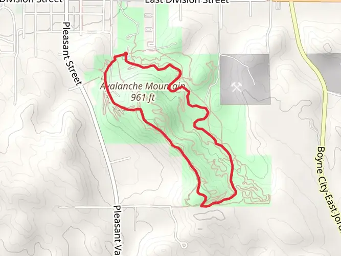
29.9 km
~6 hrs 48 min
499 m
Multi-Day
“Embark on Michigan's Jordan Valley Pathway for a weekend of moderate hiking amidst historical and natural splendor.”
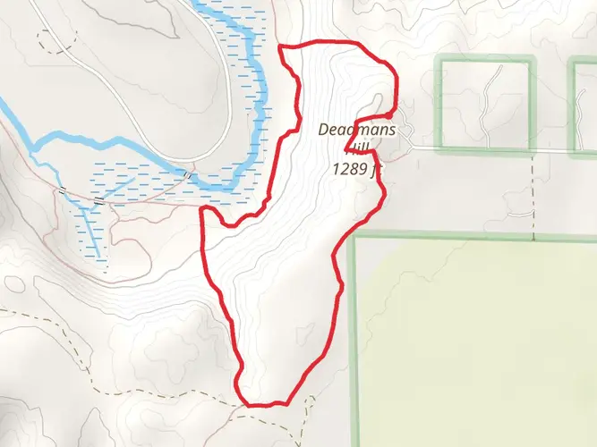
The Jordan Valley Pathway is a scenic loop trail nestled in the heart of Michigan's Lower Peninsula, near Antrim County. Spanning approximately 30 kilometers (about 18.6 miles), with an elevation gain of around 400 meters (roughly 1,300 feet), this trail offers a moderately challenging hike that can be completed over one or two days, making it an ideal weekend adventure.
Getting There To reach the trailhead, you can drive to Deadman's Hill Scenic Overlook, which is the most common starting point for the Jordan Valley Pathway. The overlook is located off US-131, about 11 kilometers (7 miles) north of Alba, Michigan. If you're using public transportation, the closest major bus and train stations are in Traverse City, from where you can rent a car or take a taxi to the trailhead.
Navigating the Trail The pathway is well-marked, but carrying a reliable navigation tool like HiiKER is recommended to stay on track and be aware of your progress. The loop can be hiked in either direction, but many choose to go clockwise, starting from the Deadman's Hill Overlook.
Landmarks and Scenery As you embark on your hike, the first few kilometers will treat you to stunning vistas from Deadman's Hill, offering panoramic views of the Jordan River Valley. The trail then descends into lush hardwood forests, home to a diverse array of flora and fauna. Keep an eye out for white-tailed deer, wild turkeys, and various bird species, including the pileated woodpecker.
Historical Significance The Jordan River Valley holds a rich logging history from the late 1800s. As you hike, you'll encounter remnants of this past, such as old logging roads and the second-growth forests that have emerged following the era of deforestation.
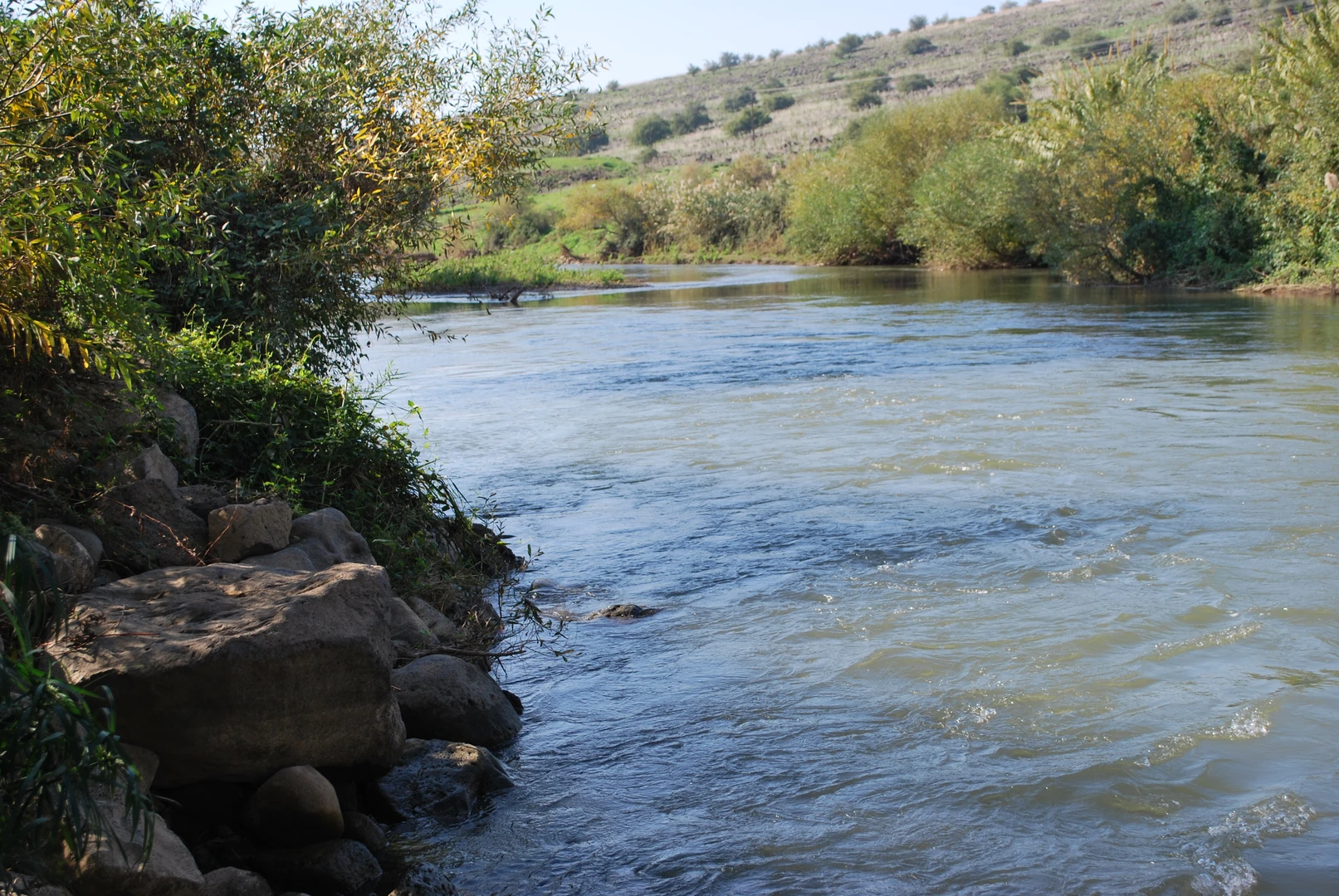
Natural Features Approximately halfway through the hike, near the 15-kilometer (9.3-mile) mark, you'll find the Jordan River Fish Hatchery, an interesting stop where you can learn about local fish species and conservation efforts. The trail also meanders alongside the pristine Jordan River, known for its excellent trout fishing.
Camping and Rest Stops For those turning their hike into an overnight trip, there are designated camping areas along the trail, such as the popular Pinney Bridge Campground, which is roughly at the midpoint of the loop. Ensure you have a Michigan Recreation Passport or camping permit if you plan to stay overnight.
Preparation Tips Before setting out, make sure you're prepared with adequate water, food, and clothing for changing weather conditions. The trail can be muddy in places, especially after rain, so waterproof hiking boots are recommended. Also, be prepared for biting insects during the warmer months by bringing insect repellent.
Remember, the Jordan Valley Pathway is a Leave No Trace area, so pack out all your trash and respect the natural environment to preserve its beauty for future hikers.

What to expect?
Activity types
Frequently asked questions
How long does the Jordan Valley Pathway take to hike?
The Jordan Valley Pathway is 29.88 km, or about 18.6 miles, with roughly 499 m of climbing, so most hikers treat it as a solid full-day hike or an overnight loop. Strong hikers can finish it in one long day, while many split it into two days to spend more time at Deadman's Hill and in the Jordan River Valley.
Where do you start the Jordan Valley Pathway and where can you park?
A common starting point for the Jordan Valley Pathway is Deadman's Hill Scenic Overlook, reached via Deadmans Hill Road near US-131 north of Alba. The official pathway map also marks parking access along the route, and Deadman's Hill is the best-known trailhead for stepping straight into the Jordan River Valley section.
Is the Jordan Valley Pathway a loop trail or an out-and-back?
The Jordan Valley Pathway is a loop, which makes route planning simpler because the hike finishes back near the starting area rather than requiring a shuttle. The mapped pathway is about 18 miles long and includes signed segments around roads such as Deadmans Hill Road, Jordan River Road, Pinney Bridge Road, Cascade Road, Turner Road, Francis Road, Marsh Road, and Harvey Road.
How difficult is the Jordan Valley Pathway in Michigan?
The Jordan Valley Pathway is generally considered a medium-difficulty hike. Its challenge comes from nearly 30 km of distance, about 499 m of elevation gain, and repeated ups and downs through the hilly Jordan River Valley rather than from technical scrambling.
Can you camp near the Jordan Valley Pathway?
Yes. Pinney Bridge State Forest Campground is a nearby option on the Jordan River, about 3 miles west of the pathway, with 15 tent-only walk-in sites about 200 yards from the parking area. It is a rustic campground with vault toilets and a hand-pump well, which makes it a practical base for an overnight Jordan Valley Pathway trip.
What are the main landmarks on the Jordan Valley Pathway?
The best-known landmark on the Jordan Valley Pathway is Deadman's Hill, a scenic overlook with broad views across the Jordan River Valley. The official map also shows the route passing near the Jordan River National Fish Hatchery, and much of the hike travels through forested ridges and valley terrain tied closely to the Jordan River corridor.
Can you hike the Jordan Valley Pathway in winter?
Yes. As a nonmotorized state forest pathway, the Jordan Valley Pathway can be used in winter for activities such as cross-country skiing and snowshoeing unless a temporary closure is in effect. Winter travel changes the difficulty significantly, though, because the route is long, hilly, and can be snowy or icy in exposed sections and shaded forest.
Comments and Reviews
User comments, reviews and discussions about the Jordan Valley Pathway, Michigan.
4.25
average rating out of 5
8 rating(s)