Download
3D Flyover
Add to list
More
7.1 km
~1 hrs 32 min
81 m
Out and Back
“From Burnside Bridge to Snavely Ford, wander creekshade and big-sky fields steeped in history.”
This easy loop-to-lollipop style walk stays on the quiet, greener southern end of Antietam National Battlefield, linking the iconic Burnside Bridge with the creekside Snavely Ford corridor and the open farmland around the Sherrick Farm area. Expect about 7 km / 4.3 mi with roughly 100 m / 330 ft of total climbing—mostly gentle grades with a few short, punchier rises where the trail leaves the creek and crosses fields.
Getting to the start (car + public transport)
By car: The most straightforward start is the Burnside Bridge (Auto Tour Stop 8) parking area on Burnside Bridge Road, near Sharpsburg/Keedysville, Maryland (a well-known landmark within Antietam National Battlefield). From the lot, you’ll have immediate access to the bridge overlook and the trail network around the creek. The Antietam Visitor Center is at 5831 Dunker Church Rd, Sharpsburg, MD 21782 if you want to orient first, pick up current conditions, or use restrooms before driving down to the bridge area. (nps.gov)
By public transport: There isn’t practical, frequent public transit directly to the battlefield trailheads. The closest realistic approach is to reach Hagerstown, MD by regional bus/rail connections, then use a rideshare/taxi to the Burnside Bridge area (roughly a 20–30 minute drive depending on traffic). If you’re trying to do this car-free, plan your return ride in advance—cell service can be variable in rural pockets.
What the route feels like underfoot
From the Burnside Bridge area, you’ll be on a mix of mowed grass paths, packed dirt, and short road/drive segments typical of battlefield trails. After rain, the low areas near Antietam Creek can be soft or slick, and grass can hold morning dew—waterproof shoes help, but this is still very manageable for most hikers.
Use HiiKER to keep track of the junctions where the route transitions between the creek corridor and the farm-field connectors; several paths in this part of the park are lightly signed and can look similar where they cross open ground.
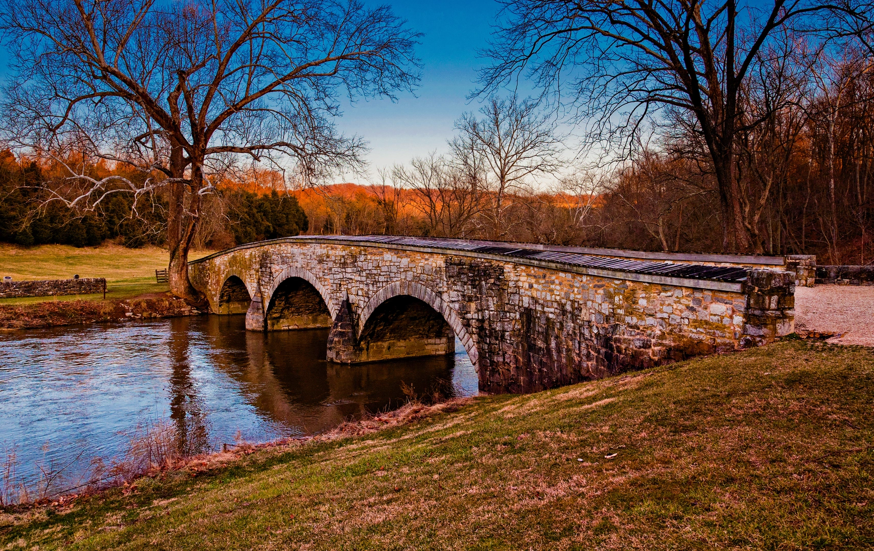
Burnside Bridge: the landmark and the terrain around it
Early on you’ll reach (or start at) Burnside Bridge, a picturesque three-arch stone bridge built in 1836—known during the battle as the Rohrbach (Lower) Bridge. (nps.gov)
The setting explains its battlefield importance: the bridge sits in a tight creek bend with steep, wooded slopes nearby. Those slopes and the narrow crossing contributed to the intense fighting here on September 17, 1862, when Union forces struggled for hours to force a crossing under fire. (nps.gov)
Even if you’re here primarily for a nature walk, pause at the overlook and along the bridge approach—this is one of the most “readable” landscapes at Antietam, where the ground itself helps you understand why the fight unfolded the way it did.
Along Antietam Creek to Snavely Ford
From the bridge area, the route works into the Snavely Ford Trail corridor, which follows Antietam Creek through a quieter, more shaded ribbon of woods. This section is where you’ll feel the most “trail” character: birdsong, leaf litter, and the steady presence of water.
Snavely Ford is historically significant because it was used as a crossing point during the battle by Union troops under Isaac Rodman—a key movement on the southern end of the field. Note that the ford itself is on private property, so you should respect any boundary cues and remain on the designated trail. (nps.gov)
What to look for in this stretch - Riparian wildlife: Expect typical Mid-Atlantic creekside species—songbirds, woodpeckers, turtles sunning on logs, and occasional deer moving between cover and fields. - Poison ivy and ticks: The creek-edge vegetation and field margins are classic tick habitat in warm months. Long socks and a quick post-hike check are smart. - High water after storms: The trail generally stays above the creek, but muddy patches and minor washouts can appear seasonally.
Sherrick Farm fields and big-sky walking
As you transition away from the creek,

Surfaces
Ground
Asphalt
Concrete
Paved
Unknown
Comments and Reviews
User comments, reviews and discussions about the Burnside Bridge via Snavely Ford Trail and Sherrick Farm Trail, Maryland.
average rating out of 5
0 rating(s)