Download
3D Flyover
Add to list
More
137.7 km
~5 days
425 m
Multi-Day
“Embark on Maine's scenic Down East Sunrise Trail, a haven for diverse hikers, rich history, and stunning wildlife vistas.”
Spanning approximately 86 miles (138 kilometers) with a modest elevation gain of around 1,312 feet (400 meters), the Down East Sunrise Trail invites hikers into the serene landscapes of Washington County, Maine. This point-to-point trail is renowned for its easy terrain, making it accessible to hikers of all skill levels.
Getting to the Trailhead
The trailhead is conveniently located near the town of Ellsworth, Maine. Those arriving by car can navigate to the parking area off High Street, which is a short drive from the junction of Route 1 and Route 3. For those relying on public transportation, options are limited, but the nearest bus stations in Ellsworth can serve as a starting point, from where a taxi or a bike ride can get you to the trailhead.
Navigating the Trail
As you embark on your journey, you'll find that the trail is well-marked and maintained, with HiiKER being an excellent tool for navigation and planning your hike. The crushed stone and gravel surface is a remnant of the trail's past life as a railway, which now provides a smooth path for hikers, cyclists, and even horseback riders.
Natural Beauty and Wildlife
The Down East Sunrise Trail meanders through a variety of landscapes, including coastal forests, wetlands, and blueberry barrens. The diverse habitats are home to an array of wildlife, so keep an eye out for white-tailed deer, moose, and a multitude of bird species, including the iconic bald eagle. The trail also offers numerous opportunities for birdwatching, especially during migration seasons.
Historical Significance
As you traverse the trail, you'll be walking along a corridor rich in history. The route was once used by the Maine Central Railroad, playing a crucial role in the transportation of goods and people across the region. Remnants of this era can be seen in the form of old railroad bridges and historic towns that dot the trail.
Landmarks and Points of Interest
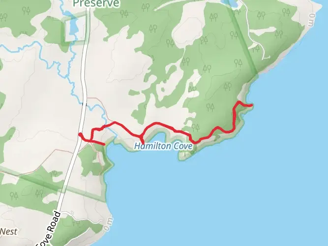
The trail provides access to several notable landmarks. Around the 30-mile mark, near Cherryfield, hikers can take a detour to visit the picturesque Narraguagus River, known for its salmon runs. Further along, near Machias, the trail crosses the causeway at the edge of the Machias River, offering stunning views and a chance to observe the tidal changes.
Preparation and Amenities
While the trail is easy in terms of difficulty, preparation is key for a successful hike. Ensure you have enough water, as sources along the trail can be scarce. There are several towns along the route where you can resupply, take a break, or even find overnight accommodations if you're tackling the trail in segments.
Seasonal Considerations
The Down East Sunrise Trail can be enjoyed year-round, with each season offering a unique experience. Spring and summer boast blooming wildflowers and lush greenery, while fall brings a spectacular display of foliage. Winter transforms the trail into a snowy wonderland, popular for snowmobiling and cross-country skiing.
Remember to check the weather forecast and trail conditions before setting out, as Maine's weather can be unpredictable, especially outside of the summer months.

What to expect?
Activity types
Comments and Reviews
User comments, reviews and discussions about the Down East Sunrise Trail, Maine.
4.0
average rating out of 5
12 rating(s)