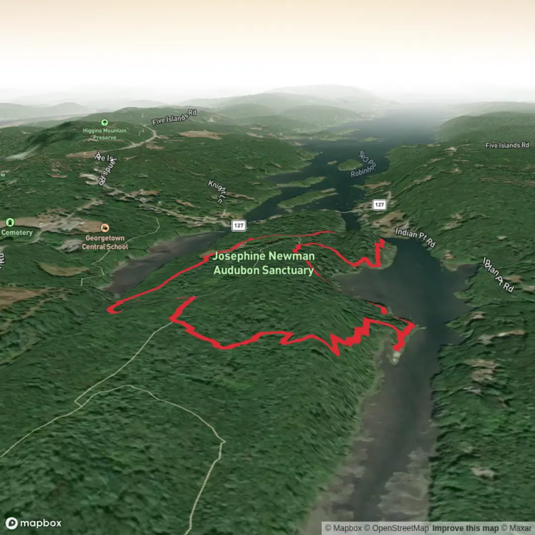
Reversing falls and Robinhood Cove via Horseshoe Trail and Geology Trail
Download
3D Preview
Add to list
More
3.3 km
~44 min
47 m
Loop
“A gentle coastal ramble through woods, marsh, and tidal bluffs, with surprisingly rugged, reflective moments.”
This easy coastal loop of about 3 km (1.9 miles) explores the Josephine Newman Audubon Sanctuary in Georgetown, Maine, combining the Horseshoe Trail with the Geology Trail for a short outing that feels varied from start to finish. Although the overall elevation gain is modest—roughly 0 to 30 m (0 to 100 ft), depending on the exact line you follow—the terrain is not completely flat. Expect a mostly gentle walk with a few short uneven or steeper sections, especially where the Geology Trail drops toward Robinhood Cove and passes over roots, rock, and damp ground. Maine Audubon describes the Geology Trail as the sanctuary’s most rigorous segment, while the Horseshoe Trail offers easier walking for much of the route. (maineaudubon.org)
The route begins from the parking area on the Sanctuary Access Road off Route 127 in Georgetown, the nearest clear trailhead landmark and access point for this hike. If arriving by car, the usual approach is from the junction of U.S. Route 1 and Route 127 in Woolwich: follow Route 127 south for about 9.1 miles (14.6 km) to Georgetown, then turn right at the sanctuary sign and continue to the parking area. In winter, Maine Audubon notes that the access road is not maintained, and hikers may need to park instead at the Georgetown Historical Society and walk in via the connecting trail network and wooden bridge. (maineaudubon.org)
Public transport is very limited in this part of midcoast Maine, and there is no widely available regular bus service that stops at the sanctuary trailhead. For most hikers, driving is the practical option; otherwise, a taxi or rideshare arranged from Bath, Brunswick, or nearby communities would be the most realistic alternative. That is an inference based on the sanctuary’s rural location and the access directions published by Maine Audubon rather than a listed transit service. (maineaudubon.org)
What the walk is like
From the meadow near the start, the Horseshoe Trail eases you into the landscape with relatively forgiving footing and a pleasant transition from open ground into woods. One of the first notable features is a short spur to a small waterfall and brook, a good early landmark and one of the reasons this route feels rewarding despite its short length. The sanctuary trail network then threads through mixed forest, old stone walls, and pockets of wetter ground shaped by the cove and marsh. (maineaudubon.org)
As the route links into the Geology Trail, the character changes. This section is more rugged and more varied underfoot, winding through coniferous woods before reaching Robinhood Cove. Here the trail passes bluffs, exposed bedrock, mudflats, and the edge of a cattail marsh, with several places where the shoreline and tidal landscape become the main attraction. The “reversing falls” are not a tall waterfall in the usual sense, but a tidal phenomenon where water tumbles over ledges and appears to reverse direction with the changing tide. Timing can affect how dramatic this feature looks, so checking tide times before setting out can make a big difference. (maineaudubon.org)
Because the hike is short, many walkers move at a relaxed pace and spend extra time at the shoreline viewpoints. Allow roughly 45 minutes to 1.5 hours, longer if you like stopping for birdwatching, photography, or careful footing on the rockier sections. The route is suitable for many beginners, but it is best approached as an easy nature walk rather than a fully smooth path. After rain, roots, ledge, and muddy patches can become slick. (alltrails.com)
Landmarks, nature, and wildlife
The sanctuary covers 119 acres and sits in a transition zone between Maine’s southern and Downeast coasts, which helps explain the diversity

Surfaces
Dirt
Unknown
Comments and Reviews
User comments, reviews and discussions about the Reversing falls and Robinhood Cove via Horseshoe Trail and Geology Trail, Maine.
average rating out of 5
0 rating(s)