Stair Falls, Haskell Rock Pitch and Grand Pitch via Appalachian Trail
Download
3D Flyover
Add to list
More
14.6 km
~3 hrs 1 min
71 m
Out and Back
“Along the East Branch, ledges, pitches, and Grand Pitch turn a gentle forest walk dramatic.”
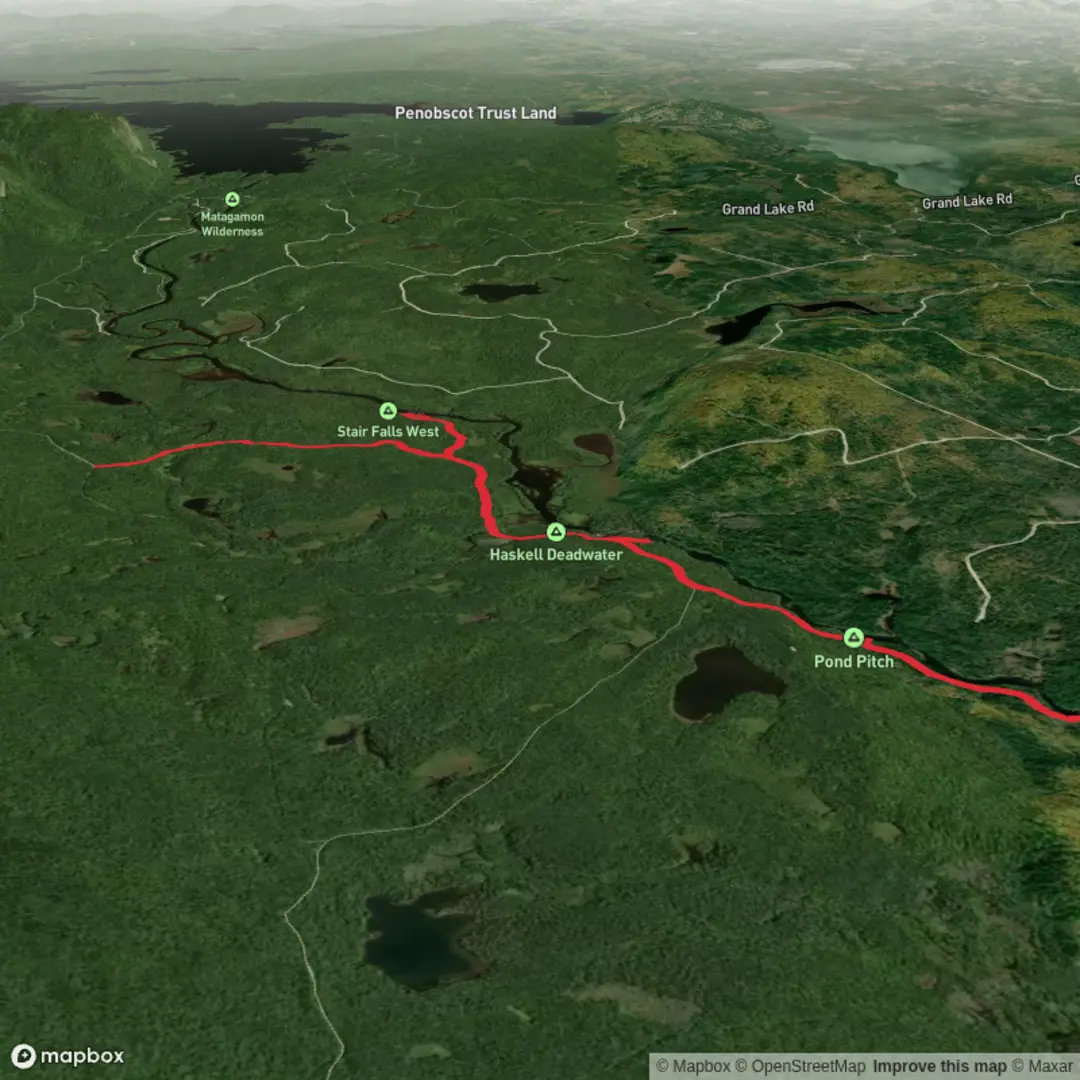
This easy riverside outing in the north section of Katahdin Woods and Waters National Monument links several of the East Branch Penobscot’s best-known features in one walk: Stair Falls, Haskell Rock Pitch, and Grand Pitch. Expect roughly 15 km / 9.3 miles round trip with only about 100 m / 330 ft of total climbing, though the terrain includes uneven tread, roots, wet patches, and short side paths to viewpoints that can make it feel a little more involved than the elevation profile suggests. The route largely follows old woods roads and the International Appalachian Trail corridor beside the river, making it a good choice for hikers who want dramatic water features without a major mountain ascent. (mainetrailfinder.com)
The usual starting point is the Haskell Gate / Grand Pitch Trailhead area in Katahdin Woods and Waters National Monument, reached from the Shin Pond Road and the Matagamon area north of Patten, Maine. A practical nearby landmark for navigation is Matagamon Wilderness Campground and Store, near Grand Lake Road, T5 R8 WELS, Maine, with the trail access continuing a few miles beyond into the monument road system. By car, the standard approach is from I-95 Exit 264 to ME-158/ME-11, then through Patten, then east and north on ME-159 (Shin Pond Road) for about 26 miles to the Matagamon area, followed by the monument access road to the trailhead. Public transport is extremely limited here; most hikers should plan on driving, arranging a private shuttle from the Patten or Shin Pond area, or combining a long-distance bus connection to the broader region with a pre-booked local transfer. (mainetrailfinder.com)
The first part of the walk is gentle and straightforward, following a broad double-track road for about 1 mile / 1.6 km toward the East Branch Penobscot River. This opening section is usually the easiest underfoot and gives a good sense of the landscape: low-relief forest, old logging corridors, and the broad river valley that defines this part of northern Maine. An old rock pit is passed early on, a reminder that this is not wilderness untouched by people, but a landscape shaped by logging, river travel, and working forest roads. (mainetrailfinder.com)
Waterfalls and river features
At around 1 mile / 1.6 km from the start, a side trail branches off for Stair Falls. The spur is about 0.3 mile / 0.5 km each way according to the Maine IAT guide, while National Park Service material describes the Stair Falls outing itself as about 4 miles / 6.4 km round trip from the trailhead, so hikers doing the full combination route should think of Stair Falls as a short but worthwhile detour rather than a separate hike. The falls are not a single vertical plunge; instead, the river drops over a sequence of ledges that resemble steps, which is where the name comes from. This is one of the most distinctive hydrologic features on the East Branch and can be especially impressive in high water, when the ledges fill with fast, surging current. (maineiat.org)
Back on the main route, the trail continues only a short distance before narrowing and drawing closer to the river. Haskell Rock Pitch arrives at about 2 miles / 3.2 km from the trailhead. This is one of the classic “pitches” of the East Branch: a forceful rapid constricted by bedrock, with sculpted stone and fast-moving water creating a much wilder feel than the easy approach suggests. The terrain here is still not especially steep, but footing near the river can be slick, especially after rain or during shoulder-season conditions. Keep children close and give the water plenty of space; the danger here comes less from exposure and more from slippery rock and powerful current. (mainetrailfinder.com)
Continuing downstream, the trail stays close to the East Branch for another 1 mile / 1.6 km to Pond Pitch, then another 0.5 mile / 0.8 km to the Grand Pitch Lean-to area. A short side path leads to Grand Pitch, the largest and most dramatic drop on this section of river. Sources differ on the exact height, with the Maine IAT guide describing it as a dramatic 20-foot / 6 m drop, while other regional descriptions characterize it as even larger; either way, it is the standout waterfall feature of the route and the visual high point for many hikers. (mainetrailfinder.com

Comments and Reviews
User comments, reviews and discussions about the Stair Falls, Haskell Rock Pitch and Grand Pitch via Appalachian Trail, Maine.
average rating out of 5
0 rating(s)