Download
3D Flyover
Add to list
More
21.5 km
~5 hrs 58 min
1001 m
Multi-Day
“Embark on the Crocker Cirque Loop, a rugged Maine adventure revealing breathtaking vistas and profound wilderness serenity.”
The Crocker Cirque Loop is a challenging and rewarding hike located near Franklin County, Maine, offering an immersive experience into the rugged terrain of the Appalachian Mountains. Spanning approximately 22 kilometers (about 13.7 miles) with an elevation gain of around 1000 meters (3280 feet), this loop trail is designed for seasoned hikers seeking a full-day adventure.
Getting to the Trailhead To reach the trailhead, hikers can drive to Caribou Valley Road, which is the closest landmark to the starting point. The road is accessible from Route 16 near Stratton, Maine. There is a parking area where the trail begins, but it's important to note that Caribou Valley Road can be rough, and a high-clearance vehicle is recommended. Public transport options are limited in this rural area, so driving is the most feasible option for reaching the trailhead.
Navigating the Trail The Crocker Cirque Loop is best tackled with a reliable navigation tool like HiiKER, which provides detailed maps and GPS coordinates to keep you on the right path. The trail is marked, but due to the remote nature of the area, having a digital map can be invaluable, especially in areas where the trail may be less defined.
Trail Experience As you embark on the loop, you'll be immediately greeted by the dense forests of Maine, with the path gradually ascending through a mix of hardwoods and conifers. The first few kilometers will test your endurance with a steady climb, and as you gain elevation, you'll notice the vegetation changing, with spruce and fir trees becoming more dominant.
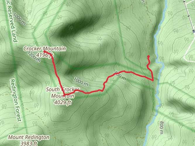
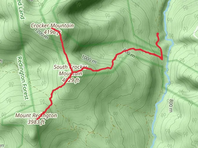
Landmarks and Scenery One of the highlights of the hike is the Crocker Cirque itself, a glacial cirque that lies between Crocker Mountain and South Crocker Mountain. This natural amphitheater is a stunning geological feature, and you'll reach it after approximately 8 kilometers (5 miles) into the hike. The cirque is a great spot to take a break and enjoy the serenity of the wilderness.
Continuing on, the trail will lead you to the summit of South Crocker Mountain, which offers expansive views of the surrounding landscape. From here, you can see the impressive Mount Abraham to the northeast and the Bigelow Range to the east. The summit of South Crocker Mountain marks roughly the halfway point of the loop.
Wildlife and Nature Throughout the hike, keep an eye out for local wildlife, including moose, black bears, and various bird species. The area is also known for its diverse plant life, with wildflowers blooming in the spring and summer, and a spectacular display of fall foliage in the autumn months.
Historical Significance The region holds historical significance as part of the Appalachian Trail corridor, a long-distance hiking trail that extends from Georgia to Maine. The Crocker Cirque Loop intersects with the Appalachian Trail, allowing hikers to experience a portion of this iconic trail.
Preparation and Safety Given the trail's difficulty rating and remote location, it's essential to be well-prepared. Bring plenty of water, high-energy food, and layers of clothing to adapt to changing weather conditions. Ensure you have a first-aid kit, a headlamp, and a backup power source for your navigation device. Always check the weather forecast before setting out, and inform someone of your hiking plans.
Conclusion The Crocker Cirque Loop is a demanding but incredibly rewarding hike that offers a taste of Maine's wild beauty. With its challenging terrain, stunning vistas, and rich history, it's a must-do for any avid hiker looking to explore the Appalachian Mountains.

What to expect?
Activity types
Frequently asked questions
How long does The Crocker Cirque Loop take to hike in Franklin County, Maine?
The Crocker Cirque Loop covers 21.52 km, or about 13.4 miles, with 1001 m of climbing, so it is usually treated as a strenuous full-day hike. Strong hikers often plan for roughly 8 to 11 hours depending on pace, trail conditions, and how long is spent on the steeper Appalachian Trail sections around the Crockers.
How difficult is The Crocker Cirque Loop and who is it best suited for?
The Crocker Cirque Loop is rated Difficult, and that fits the numbers: 21.52 km with 1001 m of elevation gain. It is best suited to experienced hikers who are comfortable with a long mountain day, sustained climbing, and remote terrain in Maine’s High Peaks region rather than beginners looking for a short summit walk.
Where do you park for The Crocker Cirque Loop and is Caribou Valley Road rough?
Access is typically from Caribou Valley Road near Route 27 by Stratton, where there is parking used for hikes into the Crocker Mountain area. Caribou Valley Road is widely noted as rough and can be washed out or deeply rutted, so a high-clearance vehicle is the safer choice for reaching the trailhead area.
Does The Crocker Cirque Loop follow the Appalachian Trail near Crocker Mountain?
Yes. The loop uses the Crocker Mountain area in western Maine, where the Appalachian Trail passes through the Crocker Mountain Unit. That section of the A.T. is a major recreation corridor in the area, and the route is known for steep forested climbing and long ridge travel around South Crocker and North Crocker.
Can you backpack The Crocker Cirque Loop or is it only a day hike?
The Crocker Cirque Loop is long enough to be done either as a very demanding day hike or as a short overnight for hikers who prefer a slower pace. With a multi-day trail type, a backpacking setup can make sense, especially for anyone wanting more time on the ridge and less pressure to cover all 21.52 km and 1001 m of ascent in one push.
Is The Crocker Cirque Loop dog friendly?
Dogs are generally allowed on Appalachian Trail sections in Maine, and Maine’s hiking guidance also recognizes hiking with dogs on public lands. For this loop, the practical issue is not a blanket dog ban but the route’s length, steepness, and rough access road, so it is better suited to trail-experienced dogs with strong endurance.
Comments and Reviews
User comments, reviews and discussions about the The Crocker Cirque Loop, Maine.
4.5
average rating out of 5
8 rating(s)