Download
3D Flyover
Add to list
More
100.9 km
~4 days
368 m
Multi-Day
“Embark on Iowa's Wabash Trace Nature Trail, a historic and picturesque haven for outdoor enthusiasts.”
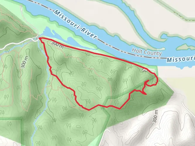
Spanning approximately 63 miles (around 101 km) with an elevation gain of roughly 984 feet (around 300 meters), the Wabash Trace Nature Trail offers an immersive experience through the scenic landscapes of southwestern Iowa. This point-to-point trail, which begins near Page County, is a converted railroad track that now serves as a peaceful retreat for hikers, cyclists, and nature enthusiasts.
Getting to the Trailhead
The trailhead is located near the city of Council Bluffs, Iowa. For those driving, you can start your journey at the Wabash Trace Nature Trail parking area, which is accessible via County Road L20. If you're using public transportation, the nearest bus stops are in Council Bluffs, from where you can take a taxi or ride-sharing service to reach the trailhead.
Navigating the Trail
As you embark on the Wabash Trace Nature Trail, you'll find that the path is well-maintained with a crushed limestone surface, making it suitable for both walking and biking. Hikers can utilize the HiiKER app to navigate the trail, ensuring they stay on the correct path and can pinpoint their location at any time.
Landmarks and Natural Beauty
The trail meanders through a variety of landscapes, including lush forests, serene farmlands, and quaint small towns. Notable landmarks along the route include the Imogene trailhead, which is home to the famous Emerald Isle, a must-visit for its Irish hospitality and charm. As you continue, the trail takes you through Shenandoah, a town known for its apple orchards and the historical significance of the Everly Brothers.
Wildlife and Flora
The Wabash Trace Nature Trail is a haven for wildlife. Deer, wild turkeys, and a plethora of bird species can be spotted in the woodlands and fields. The trail also showcases a diverse range of flora, with wildflowers blooming in the spring and summer months, and the changing leaves providing a colorful display in the fall.
Historical Significance
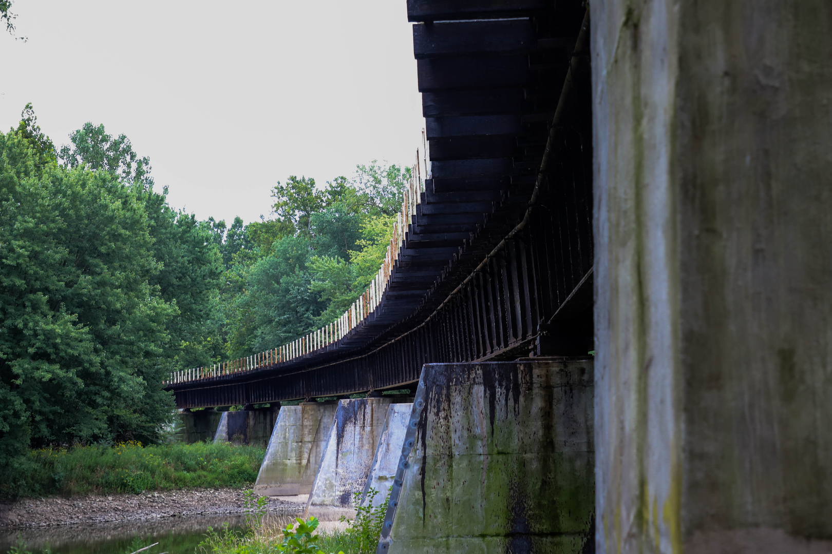
The trail follows the former route of the Wabash Railroad, which played a crucial role in the development of the region's economy. Hikers walking this path are treading along a piece of history that helped shape the Midwest, with several interpretive signs along the way providing insights into the area's past.
Preparation and Planning
Given the trail's length, it's important to plan for multiple days of hiking if you intend to complete the entire route. There are several access points along the trail for those who prefer shorter treks. Ensure you have adequate water and provisions, as some stretches of the trail have limited facilities. Also, be prepared for varying weather conditions and check local forecasts before setting out.
Conclusion
The Wabash Trace Nature Trail is a journey through the heartland of America, offering a unique blend of natural beauty, wildlife, and history. Whether you're looking for a long-distance adventure or a short, peaceful hike, this trail provides an opportunity to connect with the great outdoors and the rich heritage of Iowa.

What to expect?
Activity types
Frequently asked questions
How long is the Wabash Trace Nature Trail and how many days does it take to complete?
The Wabash Trace Nature Trail is about 100.87 km, or roughly 63 miles, from the Council Bluffs area to Blanchard near the Iowa-Missouri state line. Because the route is long but relatively gentle, many hikers break it into a two- to four-day trip, while strong walkers sometimes cover shorter town-to-town sections such as Malvern to Shenandoah in a day.
Where does the Wabash Trace Nature Trail start and end?
The Wabash Trace Nature Trail runs point to point across southwestern Iowa, beginning in Council Bluffs and continuing south through towns including Mineola, Silver City, Malvern, Imogene, Shenandoah, and Coin before reaching Blanchard near the Missouri border. That layout makes shuttle planning important for anyone hiking the full route.
What is the surface like on the Wabash Trace Nature Trail?
Most of the Wabash Trace Nature Trail has a crushed limestone surface because it follows a former railroad corridor. A few sections around towns such as Silver City, Malvern, and Shenandoah are asphalt or concrete, but the dominant tread is firm limestone, which helps explain why the route is generally rated easy.
Is the Wabash Trace Nature Trail difficult for beginner hikers?
The Wabash Trace Nature Trail is generally considered easy, with only about 368 m of total elevation gain spread across more than 100 km. Its rail-trail grade keeps climbs gradual rather than steep, so the main challenge is distance and exposure over a long point-to-point route rather than technical terrain.
Are dogs allowed on the Wabash Trace Nature Trail?
Dogs are allowed on the Wabash Trace Nature Trail as long as they are kept on a leash. The trail's published rules also distinguish the main multi-use trail from the separate equestrian route, so hikers with dogs should stay on the designated trail surface and follow posted etiquette in town and bridge areas.
Where can you park for the Wabash Trace Nature Trail?
Parking is available at the northern end in Council Bluffs at the Iowa West Foundation Trailhead Park, and additional access points exist farther south in trail towns such as Shenandoah. For Page County sections, Shenandoah is one of the most practical staging points because the trail passes through Sportsmans Park and continues south toward Coin and Blanchard.
Which towns and landmarks are on the Wabash Trace Nature Trail in Page County?
In Page County, the Wabash Trace Nature Trail passes through Imogene, Shenandoah, Coin, and Blanchard. One of the best-known stops is the Emerald Isle in Imogene, and Shenandoah is another key trail town with multiple access points, making this county one of the most useful sections for shorter day hikes or overnight staging.
Comments and Reviews
User comments, reviews and discussions about the Wabash Trace Nature Trail, Iowa.
4.43
average rating out of 5
23 rating(s)