Download
3D Flyover
Add to list
More
1.3 km
~17 min
18 m
Loop
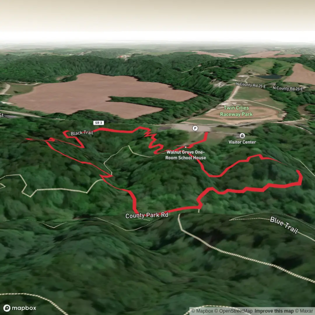
“A gentle, twisty Black Trail loop—flat, birdy, and best enjoyed with mindful footing after rain.”
This is a short, low-effort loop/walk that’s ideal for stretching your legs, birdwatching, or adding on to a longer visit—about 1 km (0.6 mi) with essentially 0 m (0 ft) of climbing. Expect mostly flat terrain with frequent little turns typical of park trail systems, so it’s worth having HiiKER open to confirm you’re staying on the Black Trail when junctions appear.
Getting to the trailhead (car + public transport)
Because the start point was only provided as “near” (no coordinates or landmark), the most reliable plan is to navigate first to the park’s main access point and then follow on-site signs to the Black Trail.
- By car: Drive to Muscatatuck Park and park in the main lot closest to the primary trail kiosk / map board (often near the busiest picnic or playground area). From there, look for Black Trail blazes/markers and confirm the correct spur on HiiKER.
- By public transport: In most of southern Indiana, public transit to county parks is limited. The practical approach is usually:
- Take intercity service to the nearest town center (if available), then
- Use a rideshare/taxi for the last miles to the park entrance.
If you share the lon/lat for the trailhead (or a pin), I can convert it to the nearest known address or recognizable landmark and give exact approach directions and the best parking spot.
What the walk is like underfoot
With negligible elevation change, the main “difficulty” factors are surface conditions and trail clarity rather than fitness.
- Surface: Typically a mix of packed dirt, mown grass edges, and possibly short gravelly or rooty patches depending on how the park maintains this segment. After rain, flat trails can hold water—watch for muddy low spots and slick leaves.
- Width & obstacles: Expect a park-style singletrack or narrow path with occasional encroaching vegetation in summer. Fallen twigs and small branches are the most common obstacles.
- Navigation: Short trails often have multiple connectors. At any fork, confirm the color/marker and use HiiKER to avoid accidentally switching onto another loop.
Landmarks, nature, and wildlife to look for
On a 1 km (0.6 mi) easy trail, the highlights tend to be subtle and seasonal rather than big “destination” features.
- Woodland edges and openings: Many park “color trails” weave between shaded tree cover and brighter edges near lawns or clearings. These transitions are great for spotting wildlife.
- Birdlife: Expect common Midwestern songbirds (especially in spring and early summer) and woodpeckers in mature trees. Early morning is usually best.
- Small mammals and reptiles/amphibians: Squirrels and chipmunks are common; in warmer months you may see garter snakes or frogs near damp areas. Give all wildlife space and watch where you place hands/feet near logs.
- Plants: In spring, look for early wildflowers along the margins; in late summer, taller seed heads and pollinator activity increase along sunny stretches.
Safety and “easy-trail” hazards that still matter
Even on a flat, short walk, a few things routinely catch people out:
- Ticks and mosquitoes: Use repellent in warm months and do a tick check afterward, especially if the trail brushes through taller grass.
- Poison ivy: Common along park edges and sunny openings—long socks help if vegetation crowds the path.
- Slippery footing: Wet leaves, algae on shaded hardpack, and mud in low areas can be slick. Shoes with decent tread are more useful than “street” sneakers after rain.
- Shared-use awareness: If the park allows bikes or has nearby multi-use paths, listen for faster users at blind corners.
Historical context of the region (what you’re walking through)
Muscatatuck and the surrounding area sit within a landscape shaped by glacial-era processes that left much of Indiana with broad, relatively gentle terrain—one reason a route like this can stay nearly flat. Human history here is also layered: southern Indiana has long been home to Indigenous peoples and later became part of early American settlement corridors, with parks often preserving small pockets of woodland and creekside habitat that once covered far more of the region.
If you tell me which Muscatatuck Park you mean (city/county/state) or provide the trailhead coordinates, I can tighten this up with the park’s specific local history (and identify any named features—creeks, memorials, old structures, or interpretive signs—along or near the Black Trail).

Surfaces
Ground
Unknown
Asphalt
Comments and Reviews
User comments, reviews and discussions about the Black Trail in Muscatatuck Park, Indiana.
average rating out of 5
0 rating(s)