Download
3D Flyover
Add to list
More
9.4 km
~2 hrs 14 min
207 m
Loop
“The Rundweg A4 Herbringhausen offers a scenic 9 km hike through forests, meadows, and historical landmarks.”
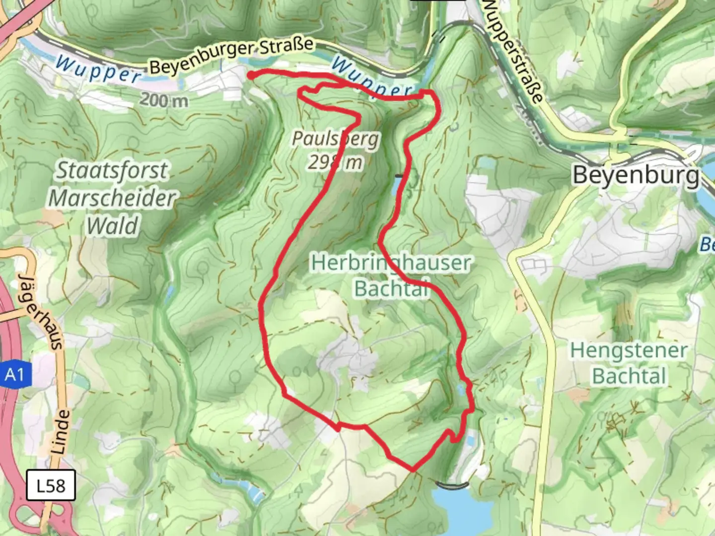
Starting near Wuppertal, Germany, the Rundweg A4 Herbringhausen is a scenic loop trail that spans approximately 9 kilometers (5.6 miles) with an elevation gain of around 200 meters (656 feet). This medium-difficulty trail offers a delightful mix of natural beauty, historical landmarks, and varied terrain, making it a rewarding experience for hikers.
Getting There
To reach the trailhead, you can either drive or use public transportation. If you're driving, set your GPS to the vicinity of Herbringhausen, Wuppertal. For those using public transport, take a train to Wuppertal Hauptbahnhof and then a local bus towards Herbringhausen. The nearest significant landmark to the trailhead is the Herbringhauser Talsperre, a picturesque reservoir that also serves as a great starting point for your hike.
Trail Overview
The Rundweg A4 Herbringhausen begins near the Herbringhauser Talsperre, a reservoir that provides a serene backdrop as you start your journey. The trail is well-marked, but it's always a good idea to have a reliable navigation tool like HiiKER to ensure you stay on track.
Natural Beauty and Wildlife
As you make your way along the trail, you'll traverse through dense forests, open meadows, and along the banks of the reservoir. The diverse landscape is home to a variety of flora and fauna. Keep an eye out for native bird species, deer, and small mammals that inhabit the area. The forested sections are particularly beautiful in the fall when the leaves change color, offering a vibrant display of autumn hues.
Historical Significance
The region around Wuppertal has a rich history, and the Rundweg A4 Herbringhausen is no exception. Along the trail, you'll come across remnants of old farmhouses and mills that date back several centuries. These historical landmarks offer a glimpse into the rural life of the past. One notable site is the old mill near the halfway point of the trail, which has been partially restored and provides an interesting stop for history enthusiasts.
Key Landmarks and Points of Interest
- Herbringhauser Talsperre: Starting and ending point of the trail, this reservoir is a popular spot for picnics and offers stunning views.
- Old Mill: Located approximately 4.5 kilometers (2.8 miles) into the hike, this partially restored mill is a great place to take a break and explore.
- Forest Sections: The dense forest areas are particularly enchanting, offering shade and a sense of tranquility.
- Open Meadows: These sections provide panoramic views of the surrounding countryside and are ideal for spotting wildlife.
Elevation and Terrain
The trail features a moderate elevation gain of around 200 meters (656 feet), with a mix of gentle inclines and steeper sections. The terrain varies from well-trodden paths to rocky and uneven ground, so sturdy hiking boots are recommended. The highest point of the trail offers a rewarding view of the surrounding landscape, making the climb well worth the effort.
Preparation and Tips
- Footwear: Sturdy hiking boots are recommended due to the varied terrain.
- Navigation: Use HiiKER to ensure you stay on the correct path.
- Weather: Check the weather forecast before you go, as conditions can change rapidly.
- Supplies: Bring enough water and snacks, especially if you plan to take breaks at the various points of interest.
- Wildlife: Be respectful of the local wildlife and maintain a safe distance.
The Rundweg A4 Herbringhausen offers a well-rounded hiking experience with its blend of natural beauty, historical landmarks, and varied terrain. Whether you're a seasoned hiker or a casual walker, this trail has something to offer for everyone.

Comments and Reviews
User comments, reviews and discussions about the Rundweg A4 Herbringhausen, Germany.
5.0
average rating out of 5
1 rating(s)