Download
3D Flyover
Add to list
More
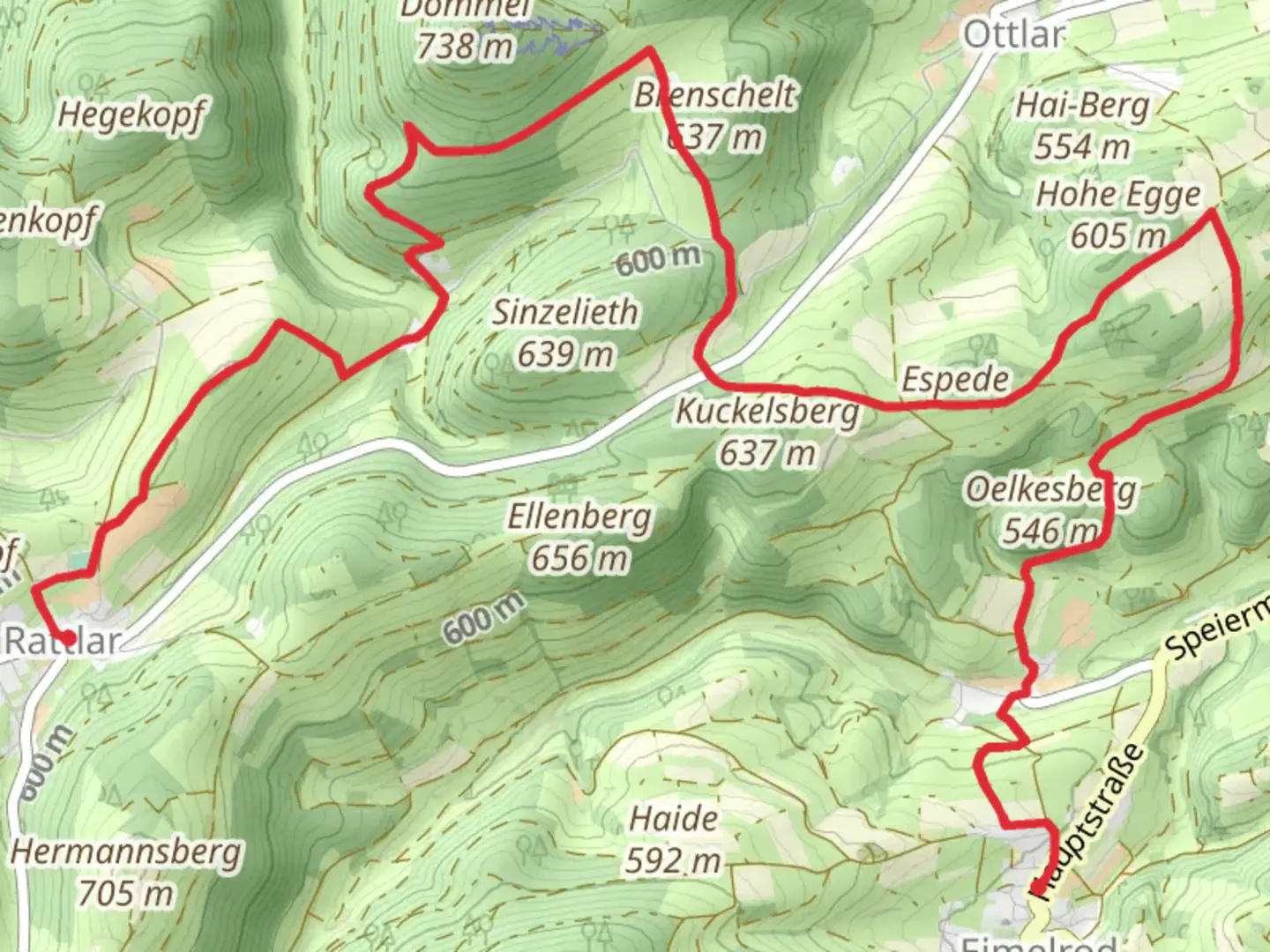
12.0 km
~2 hrs 51 min
269 m
Point-to-Point
“The Rattlar to Eimelrod Walk offers 12 kilometers of scenic landscapes, historical sites, and moderate hiking challenges.”
Starting near the picturesque region of Waldeck-Frankenberg in Germany, the Rattlar to Eimelrod Walk spans approximately 12 kilometers (7.5 miles) with an elevation gain of around 200 meters (656 feet). This point-to-point trail is estimated to be of medium difficulty, making it suitable for moderately experienced hikers.
Getting There
To reach the trailhead, you can either drive or use public transport. If driving, head towards the village of Rattlar, which is well-signposted from major roads in the region. For those using public transport, the nearest significant landmark is the town of Willingen, which has a train station. From Willingen, you can take a local bus to Rattlar. The bus services are relatively frequent, especially during the hiking season.
Trail Overview
The trail begins in the quaint village of Rattlar, known for its traditional German architecture and serene countryside. As you set off, you'll immediately be greeted by rolling hills and lush meadows. The first 3 kilometers (1.9 miles) are relatively flat, allowing you to ease into the hike while enjoying the pastoral scenery.
Historical Significance
Around the 4-kilometer (2.5-mile) mark, you'll come across remnants of old farmhouses and stone walls, indicative of the region's agricultural history. This area was historically significant for its farming communities, and you might even spot some ancient farming tools displayed along the way.
Mid-Trail Highlights
As you approach the halfway point, the trail begins to ascend gently. The elevation gain here is around 100 meters (328 feet) over the next 2 kilometers (1.2 miles). This section offers panoramic views of the surrounding valleys and forests. Keep an eye out for the diverse wildlife, including deer, foxes, and a variety of bird species.
Navigational Tips
For navigation, it's highly recommended to use the HiiKER app, which provides detailed maps and real-time updates. The trail is well-marked, but having a reliable navigation tool can enhance your hiking experience.
Flora and Fauna
The latter part of the trail takes you through dense forests, rich with oak, beech, and pine trees. During spring and summer, the forest floor is carpeted with wildflowers, adding a splash of color to your hike. This section is also a haven for birdwatchers, with species like the European robin and the great spotted woodpecker commonly sighted.
Final Stretch
As you near Eimelrod, the trail descends gently over the last 3 kilometers (1.9 miles). The village of Eimelrod is nestled in a valley, surrounded by scenic hills. This area is known for its traditional German hospitality, and you might want to explore local eateries or inns to rest and refuel.
Practical Information
The entire hike can take anywhere from 3 to 5 hours, depending on your pace and the number of stops you make. It's advisable to carry sufficient water and snacks, as there are limited facilities along the trail. Weather can be unpredictable, so pack accordingly with layers and waterproof gear.
This trail offers a perfect blend of natural beauty, historical intrigue, and moderate physical challenge, making it a rewarding experience for any hiker.

What to expect?
Activity types
Comments and Reviews
User comments, reviews and discussions about the Rattlar to Eimelrod Walk, Germany.
4.57
average rating out of 5
7 rating(s)