Download
Preview
Add to list
More
13.8 km
~4 hrs 1 min
769 m
Loop
“Embark on the Treutelskopf Loop for 14 km of scenic views, cultural landmarks, and moderate hiking challenges.”
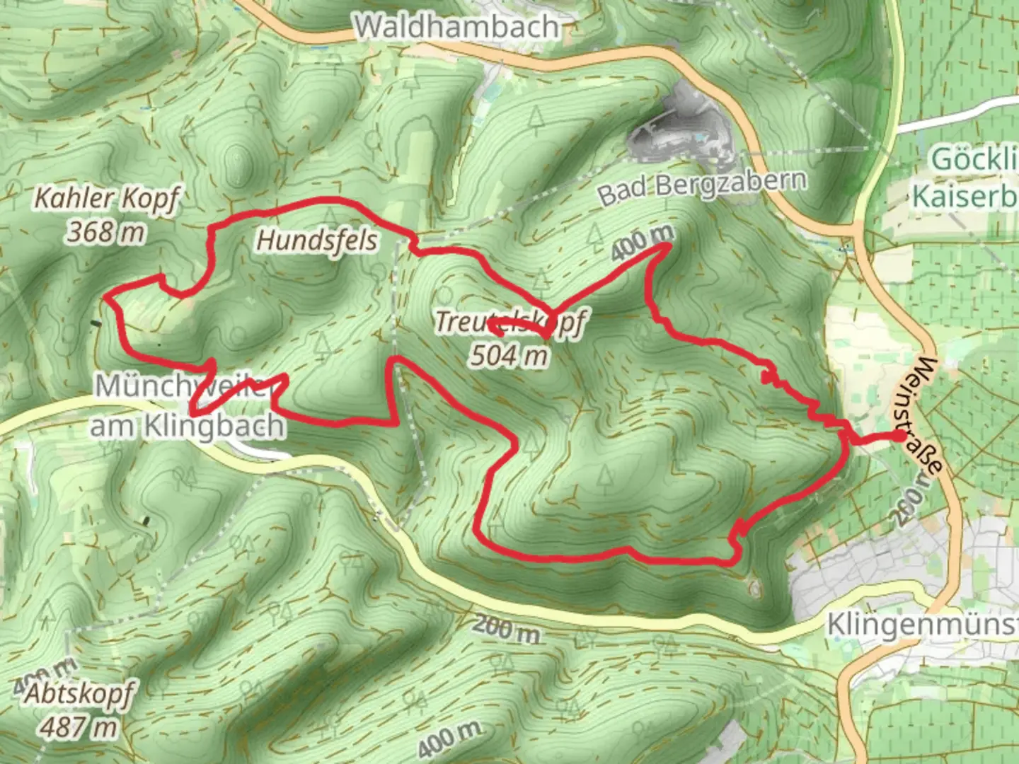
Starting near the picturesque region of Südliche Weinstraße in Germany, the Treutelskopf Loop via August Becker Weg offers a delightful 14 km (8.7 miles) journey with an elevation gain of approximately 700 meters (2,297 feet). This loop trail is rated as medium difficulty, making it suitable for moderately experienced hikers.
Getting There
To reach the trailhead, you can drive or use public transport. If driving, head towards the town of Annweiler am Trifels, which is the nearest significant landmark. From there, follow local signage to the trailhead. For those using public transport, take a train to Annweiler am Trifels station. From the station, local buses or a short taxi ride will get you to the starting point.
Trail Overview
The trail begins with a gentle ascent through lush forests, offering a serene start to your hike. As you progress, the path becomes steeper, leading you through a series of switchbacks. The initial 3 km (1.9 miles) will see you gaining around 200 meters (656 feet) in elevation, providing a good warm-up for the more challenging sections ahead.
Significant Landmarks
One of the first notable landmarks is the August Becker Weg, named after the famous German painter and writer. This section of the trail is adorned with interpretive signs that provide insights into Becker's life and works, adding a cultural touch to your hike.
Mid-Trail Highlights
Around the 7 km (4.3 miles) mark, you'll reach the summit of Treutelskopf. Here, the elevation gain totals approximately 500 meters (1,640 feet). The summit offers panoramic views of the surrounding Palatinate Forest and the Rhine Valley. It's an excellent spot for a break and some photography.
Flora and Fauna
The trail is rich in biodiversity. Keep an eye out for native wildlife such as deer, wild boar, and various bird species. The forested sections are home to a variety of trees, including oak, beech, and pine, providing ample shade and a refreshing atmosphere.
Historical Significance
The region has a deep historical significance, with remnants of medieval castles and ancient settlements scattered throughout. The nearby Trifels Castle, visible from certain points on the trail, is particularly noteworthy. This castle once held Richard the Lionheart captive and is a symbol of the region's storied past.
Navigation
For navigation, it's highly recommended to use HiiKER. The app provides detailed maps and real-time updates, ensuring you stay on the right path. The trail is well-marked, but having a reliable navigation tool adds an extra layer of security.
Final Stretch
The descent begins around the 10 km (6.2 miles) mark, where you'll lose about 200 meters (656 feet) in elevation over the next 2 km (1.2 miles). The path here is less steep but requires careful footing due to loose rocks and occasional roots.
Completing the Loop
The final 2 km (1.2 miles) bring you back to the trailhead, passing through a mix of open meadows and forested areas. This section is relatively flat, allowing you to cool down and reflect on the hike.
This trail offers a balanced mix of natural beauty, historical intrigue, and moderate physical challenge, making it a rewarding experience for those who undertake it.

What to expect?
Activity types
Comments and Reviews
User comments, reviews and discussions about the Treutelskopf Loop via August Becker Weg, Germany.
5.0
average rating out of 5
4 rating(s)