Download
Preview
Add to list
More
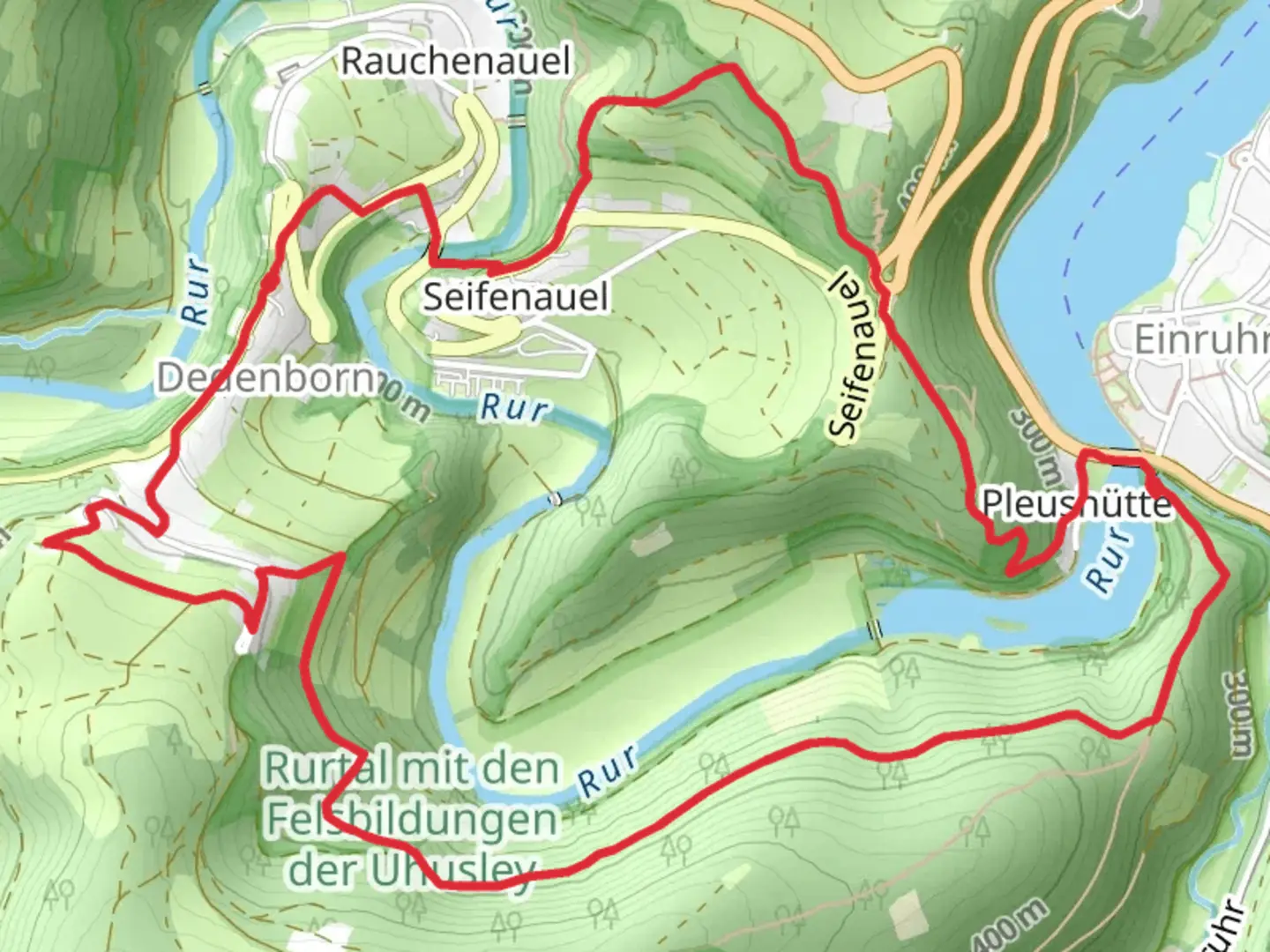
7.8 km
~2 hrs 8 min
352 m
Loop
“Explore Aachen's lush forests and historic trails on this moderately challenging 8 km loop.”
Starting near the Städteregion Aachen in Germany, this 8 km (approximately 5 miles) loop trail offers a delightful mix of natural beauty and historical intrigue. With an elevation gain of around 300 meters (approximately 984 feet), the trail is rated as medium difficulty, making it suitable for moderately experienced hikers.
Getting There
To reach the trailhead, you can either drive or use public transport. If driving, set your GPS to the nearest known address in the Städteregion Aachen. For those using public transport, take a train or bus to Aachen Hauptbahnhof, and from there, local buses can take you closer to the trailhead. Check local schedules for the most accurate routes and times.
Trail Overview
The trail begins with a gentle ascent through lush forests, where you’ll be greeted by the serene sounds of nature. Early on, you’ll encounter a mix of deciduous and coniferous trees, providing a rich tapestry of greens and browns. Keep an eye out for local wildlife such as deer and various bird species that inhabit this area.
Significant Landmarks
Around the 2 km (1.2 miles) mark, you’ll come across the first significant landmark: the Eifelsteig. This long-distance trail is renowned for its scenic beauty and historical significance, as it has been a route for travelers for centuries. Here, you can take a moment to appreciate the panoramic views of the surrounding Eifel region.
Continuing along the trail, you’ll reach the Eichheck-Runde section at approximately 4 km (2.5 miles). This part of the trail is particularly notable for its geological formations and diverse flora. The rocky outcrops and unique plant species make it a fascinating area for nature enthusiasts.
Historical Significance
The region around Städteregion Aachen is steeped in history. Aachen itself was a favored residence of Charlemagne, and the surrounding areas have been inhabited since Roman times. As you hike, you may come across remnants of old structures or paths that have been used for centuries. These historical elements add a layer of depth to your hiking experience, connecting you to the past inhabitants of this land.
Navigation and Safety
Given the trail’s moderate difficulty, it’s advisable to use a reliable navigation tool like HiiKER to keep track of your progress and ensure you stay on the correct path. The trail is well-marked, but having a digital map can provide additional peace of mind.
Flora and Fauna
As you make your way back towards the starting point, the trail descends gently, offering more opportunities to observe the local flora and fauna. The diverse ecosystem supports a variety of plant species, from wildflowers in the spring to vibrant autumn foliage. Wildlife sightings are common, so keep your camera ready.
Final Stretch
The final stretch of the trail brings you back through a mix of open meadows and forested areas, providing a pleasant and varied hiking experience. The loop nature of the trail ensures that you end where you began, making logistics simple and straightforward.
This trail offers a balanced mix of natural beauty, historical significance, and moderate physical challenge, making it a rewarding experience for those who undertake it.

What to expect?
Activity types
Comments and Reviews
User comments, reviews and discussions about the Rur via Eifelsteig and Eichheck-Runde, Germany.
average rating out of 5
0 rating(s)