Download
Preview
Add to list
More
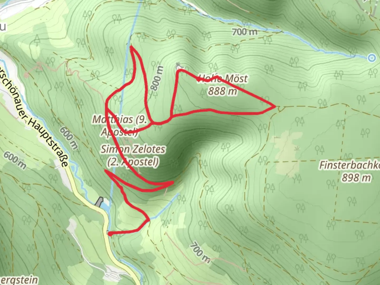
10.1 km
~2 hrs 57 min
569 m
Point-to-Point
“Embark on the Vorderer Finsterbach and Hinterer Möstfelsen Loop for a scenic, history-rich wilderness adventure.”
Starting near the picturesque town of Schmalkalden-Meiningen in Germany, the Vorderer Finsterbach and Hinterer Möstfelsen Loop is a captivating 10 km (approximately 6.2 miles) point-to-point trail with an elevation gain of around 500 meters (1,640 feet). This medium-difficulty hike offers a blend of natural beauty, historical significance, and diverse wildlife, making it a rewarding experience for outdoor enthusiasts.
Getting There
To reach the trailhead, you can either drive or use public transportation. If driving, set your GPS to Schmalkalden-Meiningen, and look for parking options near the town center. For those using public transport, take a train to the Schmalkalden-Meiningen station. From there, local buses or a short taxi ride will get you to the trailhead.
Trail Overview
The trail begins near the town center, quickly immersing you in the serene beauty of the Thuringian Forest. The initial stretch is relatively gentle, allowing you to warm up as you follow the Vorderer Finsterbach stream. The sound of flowing water and the lush greenery create a tranquil atmosphere, perfect for easing into the hike.
Significant Landmarks and Nature
As you progress, you'll encounter the Vorderer Finsterbach waterfall, approximately 3 km (1.9 miles) into the hike. This stunning natural feature is a great spot for a short break and some photos. The trail then starts to ascend more steeply, gaining elevation as you approach the Hinterer Möstfelsen.
Wildlife and Flora
The Thuringian Forest is home to a variety of wildlife, including deer, foxes, and numerous bird species. Keep an eye out for these creatures, especially in the early morning or late afternoon. The forest floor is often carpeted with wildflowers in the spring and summer, adding vibrant colors to your hike.
Historical Significance
The region around Schmalkalden-Meiningen has a rich history, dating back to medieval times. The town itself is known for its well-preserved half-timbered houses and the Wilhelmsburg Castle, which you might want to explore either before or after your hike. The trail also passes by several historical markers and old stone structures, remnants of the area's past.
Navigation and Safety
Given the trail's moderate difficulty, it's advisable to use a reliable navigation tool like HiiKER to stay on track. The path is generally well-marked, but having a digital map can be reassuring, especially in the denser sections of the forest.
Final Stretch
The final part of the hike involves a descent back towards Schmalkalden-Meiningen. This section can be a bit steep, so take your time and watch your footing. As you near the end of the trail, you'll be rewarded with panoramic views of the town and the surrounding countryside, a perfect way to conclude your adventure.
Practical Tips
- Wear sturdy hiking boots, as the trail can be rocky and uneven in places.
- Bring plenty of water and snacks, especially if you plan to take your time exploring the various landmarks.
- Check the weather forecast before heading out, as conditions can change rapidly in the forest.
This trail offers a delightful mix of natural beauty, historical intrigue, and the chance to spot some local wildlife, making it a must-do for anyone visiting the Schmalkalden-Meiningen area.

What to expect?
Activity types
Comments and Reviews
User comments, reviews and discussions about the Vorderer Finsterbach and Hinterer Möstfelsen Loop, Germany.
4.67
average rating out of 5
3 rating(s)