Download
3D Flyover
Add to list
More
14.2 km
~3 hrs 32 min
414 m
Loop
“Discover a rewarding 14 km loop in Saarpfalz-Kreis, blending natural beauty, history, and diverse wildlife.”
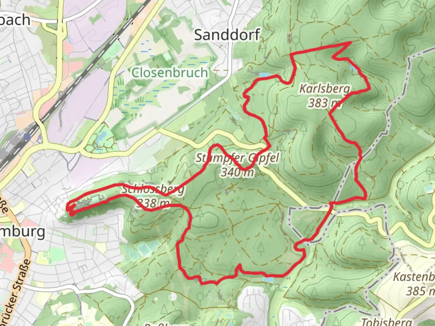
Starting near Saarpfalz-Kreis, Germany, the Stumpfer Gipfel and Eiskeller via Roetkaeppchenweg trail is a 14 km (8.7 miles) loop with an elevation gain of approximately 400 meters (1,312 feet). This medium-difficulty hike offers a blend of natural beauty, historical landmarks, and diverse wildlife, making it a rewarding experience for hikers.
Getting There
To reach the trailhead, you can drive or use public transport. If driving, set your GPS to the nearest known address: Blieskastel, Saarpfalz-Kreis, Germany. For those using public transport, take a train to Blieskastel-Lautzkirchen station, and from there, a local bus or taxi can get you to the trailhead.
Trail Overview
The trail begins with a gentle ascent through a dense forest, where you'll be surrounded by towering trees and the sounds of local birdlife. Early on, you'll encounter the Roetkaeppchenweg, a path named after the famous fairy tale "Little Red Riding Hood." This section is relatively easy and serves as a good warm-up for the more challenging parts ahead.
Key Landmarks and Sections
Stumpfer Gipfel
At around the 5 km (3.1 miles) mark, you'll reach Stumpfer Gipfel, the highest point of the trail. The climb to this peak is steep but manageable, offering panoramic views of the surrounding Saarpfalz-Kreis region. Take a moment to rest and enjoy the scenery before continuing.
Eiskeller
Descending from Stumpfer Gipfel, you'll head towards Eiskeller, a historical ice cellar used in the past for food preservation. This section of the trail is less steep and allows for a more relaxed pace. The Eiskeller itself is a fascinating structure, providing a glimpse into the area's historical methods of food storage.
Flora and Fauna
The trail is rich in biodiversity. Keep an eye out for deer, foxes, and a variety of bird species. The forest floor is often carpeted with wildflowers, especially in the spring and summer months. The mix of deciduous and coniferous trees provides a lush canopy, making this trail particularly beautiful in the autumn when the leaves change color.
Navigation and Safety
Given the trail's moderate difficulty, it's advisable to use a reliable navigation tool like HiiKER to stay on track. The trail is well-marked, but having a digital map can be helpful, especially in the denser forest sections where paths can be less obvious.
Final Stretch
The last few kilometers of the trail loop back towards the starting point, offering a mix of open meadows and forested areas. This section is relatively flat, allowing for a leisurely end to your hike. As you approach the trailhead, you'll pass through small clearings that offer final glimpses of the beautiful Saarpfalz-Kreis landscape.
This trail is a perfect blend of natural beauty, historical intrigue, and moderate physical challenge, making it an excellent choice for hikers looking to explore the Saarpfalz-Kreis region.

What to expect?
Activity types
Comments and Reviews
User comments, reviews and discussions about the Stumpfer Gipfel and Eiskeller via Roetkaeppchenweg, Germany.
4.75
average rating out of 5
4 rating(s)