Download
3D Flyover
Add to list
More
9.1 km
~2 hrs 20 min
307 m
Loop
“Explore Bavarian Forest's scenic beauty and history on this 9 km trail from Bischofsmais to Geißkopfturm.”
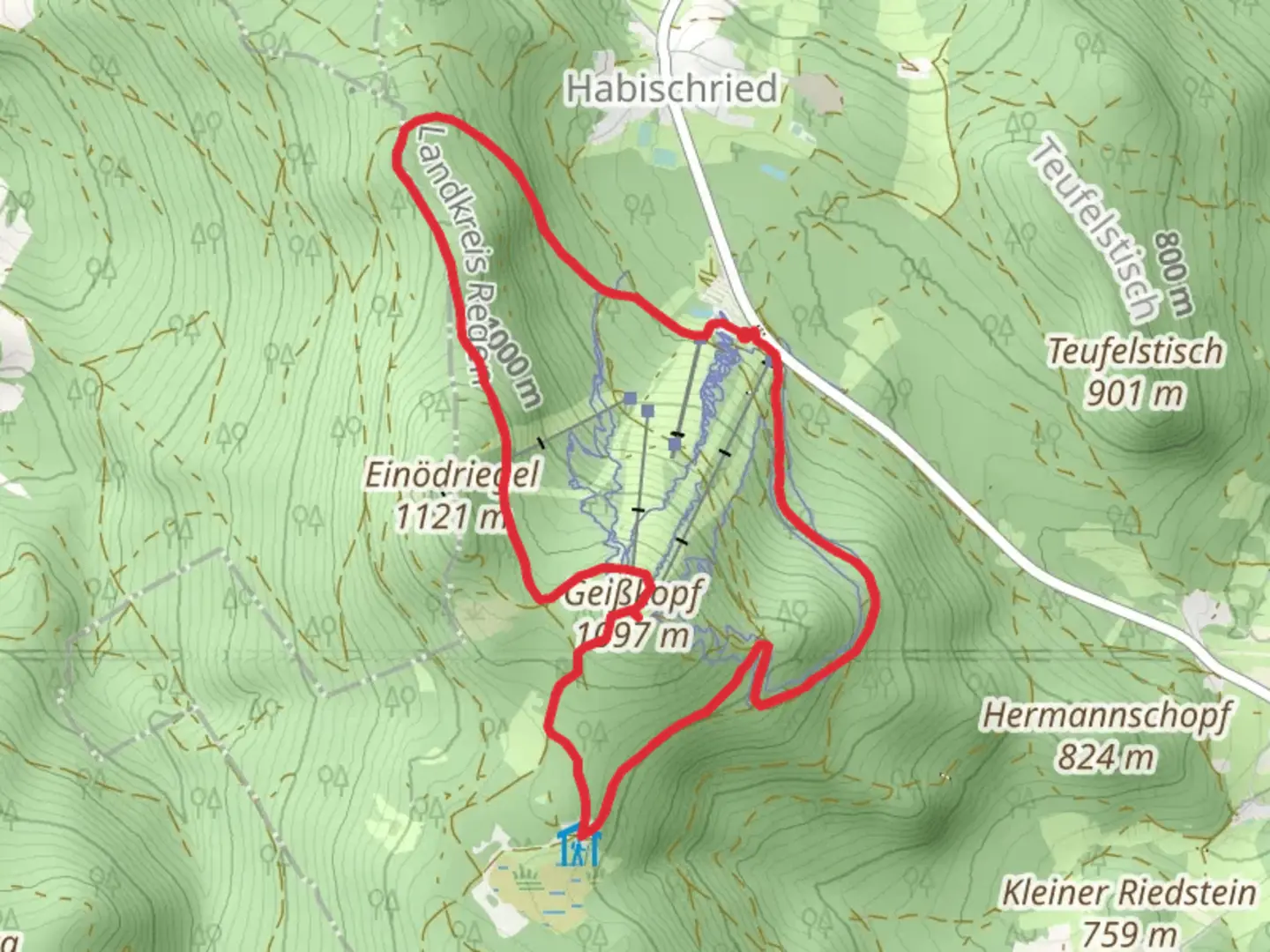
Starting near the charming town of Regen, Germany, the Ringstraße and Geißkopfturm via Bischofsmais trail offers a delightful 9 km (5.6 miles) loop with an elevation gain of approximately 300 meters (984 feet). This medium-difficulty hike is perfect for those looking to explore the scenic beauty and historical richness of the Bavarian Forest.
Getting There
To reach the trailhead, you can drive or use public transport. If driving, head towards Bischofsmais, a small town near Regen. There are parking facilities available near the trailhead. For those using public transport, take a train to Regen and then a local bus to Bischofsmais. The nearest significant landmark to the trailhead is the Bischofsmais town center.
Trail Overview
The trail begins in the picturesque town of Bischofsmais, known for its traditional Bavarian architecture and serene atmosphere. As you start your hike, you'll be greeted by lush forests and well-marked paths. The initial part of the trail is relatively flat, making it an excellent warm-up for the more challenging sections ahead.
Key Landmarks and Sections
Ringstraße
The first major section of the trail is the Ringstraße, a scenic route that loops around the outskirts of Bischofsmais. This part of the trail is characterized by dense forests and occasional clearings that offer stunning views of the surrounding landscape. Keep an eye out for local wildlife, including deer and various bird species. The trail here is well-maintained, making navigation straightforward.
Geißkopfturm
Approximately halfway through the hike, you'll reach the Geißkopfturm, a historic lookout tower that offers panoramic views of the Bavarian Forest. The tower stands at an elevation of around 1,097 meters (3,599 feet) and provides a perfect spot for a rest and some photography. The climb to the tower is the most challenging part of the hike, with a steep ascent that will test your endurance. However, the breathtaking views from the top make it well worth the effort.
Flora and Fauna
The trail is rich in biodiversity, with a variety of plant species that change with the seasons. In spring and summer, you'll find the forest floor carpeted with wildflowers, while autumn brings a stunning display of fall foliage. The area is also home to several species of birds, making it a great spot for birdwatching.
Historical Significance
The region around Bischofsmais has a rich history dating back to medieval times. The Geißkopfturm itself is a testament to the area's historical significance, originally built as a lookout point to monitor the surrounding forests. The trail also passes by several old farmhouses and traditional Bavarian structures, offering a glimpse into the region's past.
Navigation and Safety
For navigation, it's highly recommended to use the HiiKER app, which provides detailed maps and real-time updates. The trail is generally well-marked, but having a reliable navigation tool will ensure you stay on track. Make sure to wear sturdy hiking boots, as some sections can be rocky and uneven. Carry enough water and snacks, especially if you plan to spend time at the Geißkopfturm.
This hike offers a perfect blend of natural beauty, historical landmarks, and moderate physical challenge, making it a must-visit for anyone exploring the Bavarian Forest.

What to expect?
Activity types
Comments and Reviews
User comments, reviews and discussions about the Ringstraße and Geißkopfturm via Bischofsmais, Germany.
4.67
average rating out of 5
6 rating(s)