Download
Preview
Add to list
More
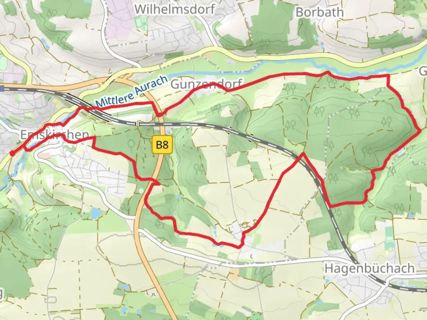
13.5 km
~3 hrs 5 min
235 m
Loop
“Discover the Emskirchen Rundwanderweg: a 14 km journey through lush landscapes, historical landmarks, and local culture.”
Starting near Neustadt an der Aisch-Bad Windsheim, Germany, the Emskirchen Rundwanderweg is a 14 km (approximately 8.7 miles) loop trail with an elevation gain of around 200 meters (656 feet). This medium-difficulty trail offers a blend of natural beauty, historical landmarks, and a touch of local culture.
Getting There
To reach the trailhead, you can take a train to Neustadt an der Aisch-Bad Windsheim station. From there, local buses or a short taxi ride will get you to the starting point near Emskirchen. If you're driving, ample parking is available near the trailhead.
Trail Overview
The trail begins in the charming village of Emskirchen, known for its picturesque half-timbered houses and serene countryside. As you set off, you'll be greeted by rolling hills and lush meadows, typical of the Franconian landscape.
Key Landmarks and Sections
Emskirchen Village
At the start, take a moment to explore Emskirchen. The village has a rich history dating back to the Middle Ages, and you can see remnants of its past in the local architecture and the St. Kilian Church, a beautiful example of Gothic design.
Forested Areas
Around the 3 km (1.9 miles) mark, you'll enter a dense forest. This section is relatively flat and offers a cool, shaded respite, especially during the warmer months. Keep an eye out for local wildlife such as deer and various bird species.
Scenic Overlook
At approximately 6 km (3.7 miles) into the hike, you'll reach a scenic overlook. This spot offers panoramic views of the surrounding countryside, making it an ideal place for a rest and some photography. The elevation gain to this point is gradual but noticeable, so take your time.
Historical Sites
Around the 9 km (5.6 miles) mark, you'll come across the ruins of an old castle. This site offers a glimpse into the region's feudal past and provides an excellent opportunity for exploration and learning. Information plaques are available to give you more context about the castle's history and significance.
Navigation and Safety
The trail is well-marked, but it's always a good idea to have a reliable navigation tool. HiiKER is an excellent app for this purpose, offering detailed maps and real-time tracking to ensure you stay on course.
Flora and Fauna
The trail is rich in biodiversity. In spring and summer, wildflowers blanket the meadows, while the forested sections are home to a variety of tree species, including oak and beech. Birdwatchers will find plenty to enjoy, with common sightings including woodpeckers and songbirds.
Final Stretch
The last 3 km (1.9 miles) of the trail bring you back towards Emskirchen. This section is relatively easy, with gentle descents and flat paths. As you approach the village, you'll pass through agricultural fields, offering a different but equally charming aspect of the local landscape.
Practical Tips
- Wear sturdy hiking boots, as some sections can be uneven.
- Bring enough water and snacks, especially if you plan to take your time exploring the historical sites.
- Check the weather forecast before you go; the trail can be muddy after rain.
This trail offers a well-rounded hiking experience, combining natural beauty, historical intrigue, and a moderate physical challenge. Whether you're a seasoned hiker or a casual walker, the Emskirchen Rundwanderweg has something to offer.

Comments and Reviews
User comments, reviews and discussions about the Emskirchen Rundwanderweg, Germany.
average rating out of 5
0 rating(s)