Download
Preview
Add to list
More
12.0 km
~3 hrs 26 min
632 m
Point-to-Point
“Embark on a scenic 12 km trail through the Bavarian Alps, rich with nature and historical charm.”
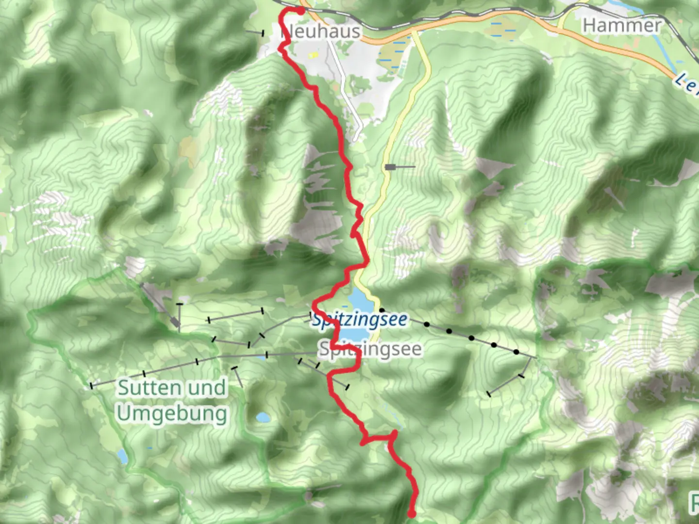
Starting near the picturesque town of Miesbach, Germany, the Spitzingsee and Bockerlbahn Weg trail offers a delightful 12 km (7.5 miles) journey through the Bavarian Alps. With an elevation gain of around 600 meters (1,970 feet), this point-to-point trail is rated as medium difficulty, making it suitable for moderately experienced hikers.
Getting There
To reach the trailhead, you can either drive or use public transport. If driving, head towards Miesbach and look for parking options near the town center. For those using public transport, take a train to Miesbach station. From there, local buses or a short taxi ride can get you to the trailhead.
Trail Overview
The trail begins near Miesbach and quickly immerses you in the serene beauty of the Bavarian countryside. As you start your hike, you'll traverse through lush forests and open meadows, offering a mix of shaded and sunlit paths. The initial part of the trail is relatively gentle, allowing you to warm up before the more challenging sections.
Significant Landmarks and Nature
Around the 3 km (1.9 miles) mark, you'll encounter the first significant elevation gain as you ascend towards the Spitzingsee area. This section can be steep, so take your time and enjoy the panoramic views of the surrounding mountains. Spitzingsee itself is a stunning alpine lake, perfect for a short break. The crystal-clear waters and the reflection of the mountains create a postcard-worthy scene.
Continuing on, the trail leads you through dense forests where you might spot local wildlife such as deer, foxes, and a variety of bird species. Keep an eye out for the distinctive Bavarian flora, including wildflowers and ancient trees.
Historical Significance
As you approach the halfway point, you'll come across remnants of the Bockerlbahn, an old narrow-gauge railway that once served the region. This historical railway was used for transporting timber and other goods and played a crucial role in the local economy. Informational plaques along the trail provide insights into the history and significance of the Bockerlbahn, making this a culturally enriching experience.
Navigation and Safety
Given the varied terrain and elevation changes, it's advisable to use a reliable navigation tool like HiiKER to stay on track. The trail is well-marked, but having a digital map can be reassuring, especially in the denser forest sections.
Final Stretch
The last few kilometers of the trail offer a gentle descent, leading you towards the endpoint near the town of Schliersee. This section is less strenuous, allowing you to relax and take in the final views of the Bavarian Alps. Schliersee is another charming town, where you can explore local cafes and restaurants to celebrate the completion of your hike.
Wildlife and Flora
Throughout the hike, you'll be surrounded by the rich biodiversity of the Bavarian Alps. The area is home to various species of birds, including woodpeckers and eagles. The flora is equally impressive, with alpine flowers blooming in the spring and summer months, adding vibrant colors to the landscape.
Practical Tips
- Wear sturdy hiking boots, as the trail can be rocky and uneven in places.
- Carry enough water and snacks, especially if you plan to take breaks at scenic spots like Spitzingsee.
- Check the weather forecast before you go, as conditions can change rapidly in the mountains.
- If you're hiking in the winter months, be prepared for snow and icy conditions, and consider bringing trekking poles for added stability.
This trail offers a perfect blend of natural beauty, historical intrigue, and moderate physical challenge, making it a rewarding experience for any hiker.

What to expect?
Activity types
Comments and Reviews
User comments, reviews and discussions about the Spitzingsee and Bockerlbahn Weg, Germany.
average rating out of 5
0 rating(s)