Download
Preview
Add to list
More
7.2 km
~1 hrs 40 min
138 m
Loop
“Explore Merzig-Wadern's 7 km loop: serene reservoirs, historical ruins, rich biodiversity, and scenic vistas.”
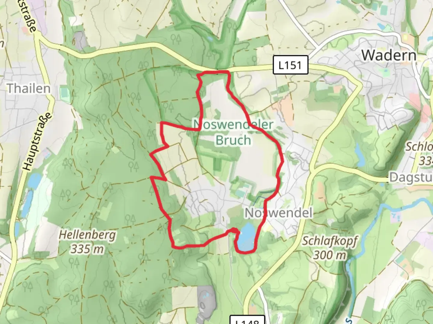
Starting near Merzig-Wadern in Germany, this 7 km (approximately 4.3 miles) loop trail offers a delightful mix of natural beauty and historical intrigue. With an elevation gain of around 100 meters (328 feet), it's rated as a medium difficulty hike, making it suitable for moderately experienced hikers.
Getting There
To reach the trailhead, you can drive or use public transport. If driving, set your GPS to Noswendel, a small village near Merzig-Wadern. For those using public transport, take a train to Merzig station. From there, you can catch a local bus to Noswendel. The trailhead is conveniently located near the village center, making it easily accessible.
Trail Overview
The loop begins near the picturesque Stausee Noswendel, a serene reservoir surrounded by lush greenery. As you start your hike, you'll be greeted by the tranquil waters of the reservoir, which is a great spot for a quick photo or a moment of reflection. The trail then meanders through the Noswendeler Bruch, a protected wetland area known for its rich biodiversity.
Significant Landmarks and Nature
Around the 2 km (1.2 miles) mark, you'll come across the first significant landmark: the remnants of an old mill. This historical site offers a glimpse into the region's past, where milling was a crucial part of the local economy. Continuing on, the trail takes you through dense forests and open meadows, providing a variety of landscapes to enjoy.
At approximately 4 km (2.5 miles), you'll reach a viewpoint that offers stunning vistas of the surrounding countryside. This is a perfect spot to take a break and soak in the natural beauty. The elevation gain is gradual, making the ascent manageable for most hikers.
Wildlife and Flora
The Noswendeler Bruch is a haven for birdwatchers. Keep an eye out for species like the European kingfisher and the grey heron. The wetland area is also home to various amphibians and insects, making it a vibrant ecosystem worth exploring. The forested sections of the trail are rich with oak, beech, and pine trees, providing ample shade and a refreshing atmosphere.
Navigation and Safety
For navigation, it's highly recommended to use the HiiKER app, which provides detailed maps and real-time updates. The trail is well-marked, but having a reliable navigation tool will enhance your hiking experience and ensure you stay on track.
Historical Significance
The region around Merzig-Wadern has a rich history dating back to Roman times. The old mill you encounter on the trail is a testament to the area's long-standing agricultural traditions. Additionally, the wetlands of Noswendeler Bruch have been preserved for their ecological importance, reflecting the community's commitment to conservation.
Final Stretch
As you loop back towards Stausee Noswendel, the trail offers a gentle descent, making for a pleasant end to your hike. The final kilometer (0.6 miles) brings you back to the reservoir, where you can relax and perhaps enjoy a picnic by the water.
This 7 km loop is a perfect blend of natural beauty, historical landmarks, and diverse wildlife, making it a rewarding hike for those looking to explore the Merzig-Wadern region.

What to expect?
Activity types
Comments and Reviews
User comments, reviews and discussions about the Stausee Noswendel and Noswendeler Bruch Loop, Germany.
4.17
average rating out of 5
6 rating(s)