Download
Preview
Add to list
More
13.6 km
~3 hrs 32 min
494 m
Point-to-Point
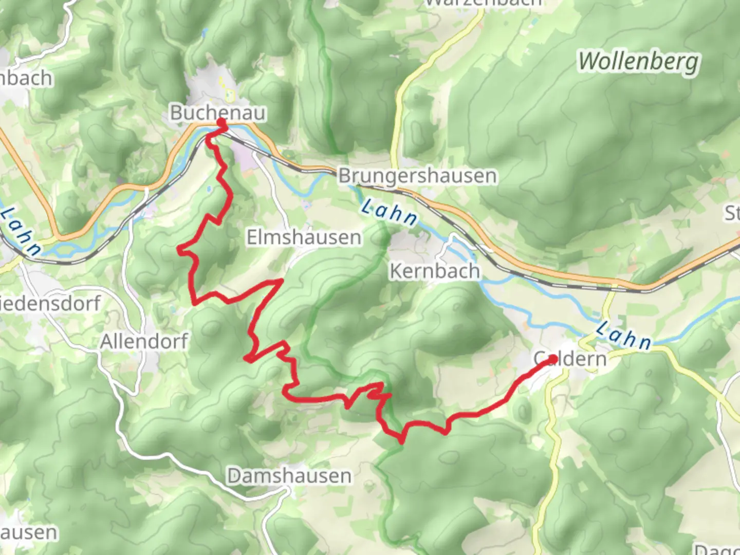
“Embark on a 14-kilometer trek from Buchenau to Caldern, rich in history, wildlife, and scenic landscapes.”
Starting your journey near Marburg-Biedenkopf, Germany, the trail from Buchenau to Caldern via Schwaelmerweg spans approximately 14 kilometers (8.7 miles) with an elevation gain of around 400 meters (1,312 feet). This point-to-point trail is rated as medium difficulty, making it suitable for moderately experienced hikers.
Getting There
To reach the trailhead, you can either drive or use public transportation. If driving, head towards Marburg-Biedenkopf and look for parking options near the starting point in Buchenau. For those using public transport, take a train or bus to Marburg and then a local bus to Buchenau. The nearest significant landmark to the trailhead is the Buchenau Castle, a picturesque starting point for your hike.
Trail Overview
The trail begins in the charming village of Buchenau, known for its historic castle and scenic landscapes. As you set off, you'll initially traverse through lush forests and rolling hills. The first few kilometers are relatively gentle, allowing you to acclimate to the terrain.
Key Landmarks and Natural Features
Around the 3-kilometer (1.9-mile) mark, you'll encounter the serene Wetschaft Valley. This area is rich in biodiversity, so keep an eye out for local wildlife such as deer, foxes, and a variety of bird species. The valley is also home to several small streams, adding to the tranquil atmosphere.
Elevation Gain and Terrain
As you progress, the trail begins to ascend more steeply. By the time you reach the 7-kilometer (4.3-mile) point, you'll have gained a significant portion of the 400 meters (1,312 feet) in elevation. This section can be challenging, with rocky paths and occasional steep inclines. Good hiking boots and trekking poles are recommended.
Historical Significance
Midway through the hike, you'll pass near the village of Wetter, which has historical significance dating back to the medieval period. The area was once a hub for trade and agriculture, and remnants of its storied past can still be seen in the form of old stone buildings and ancient farmlands.
Navigation and Safety
For navigation, it's advisable to use HiiKER, which provides detailed maps and real-time updates. The trail is well-marked, but having a reliable navigation tool ensures you stay on the right path, especially in the more remote sections.
Final Stretch to Caldern
The last segment of the trail takes you through dense forests and open meadows, offering stunning views of the surrounding countryside. As you approach Caldern, the trail descends gradually, making for a pleasant end to your hike. Caldern itself is a quaint village with a rich history, featuring traditional German architecture and a welcoming atmosphere.
Wildlife and Flora
Throughout the hike, you'll encounter a variety of flora, including oak, beech, and pine trees. In the spring and summer months, the trail is adorned with wildflowers, adding bursts of color to the landscape. Wildlife is abundant, so be prepared for possible sightings of local fauna.
Practical Tips
- Water and Snacks: Ensure you carry enough water and snacks, as there are limited facilities along the trail.
- Weather: Check the weather forecast before you set out, as conditions can change rapidly.
- Clothing: Dress in layers to accommodate varying temperatures and pack a rain jacket.
This trail offers a blend of natural beauty, moderate physical challenge, and historical intrigue, making it a rewarding experience for those who undertake it.

What to expect?
Activity types
Comments and Reviews
User comments, reviews and discussions about the Buchenau to Caldern via Schwaelmerweg, Germany.
average rating out of 5
0 rating(s)