Dorperheide, Heerenven, Eckeltse Bergen and Diekmes via Dorperheideweg
Download
3D Flyover
Add to list
More
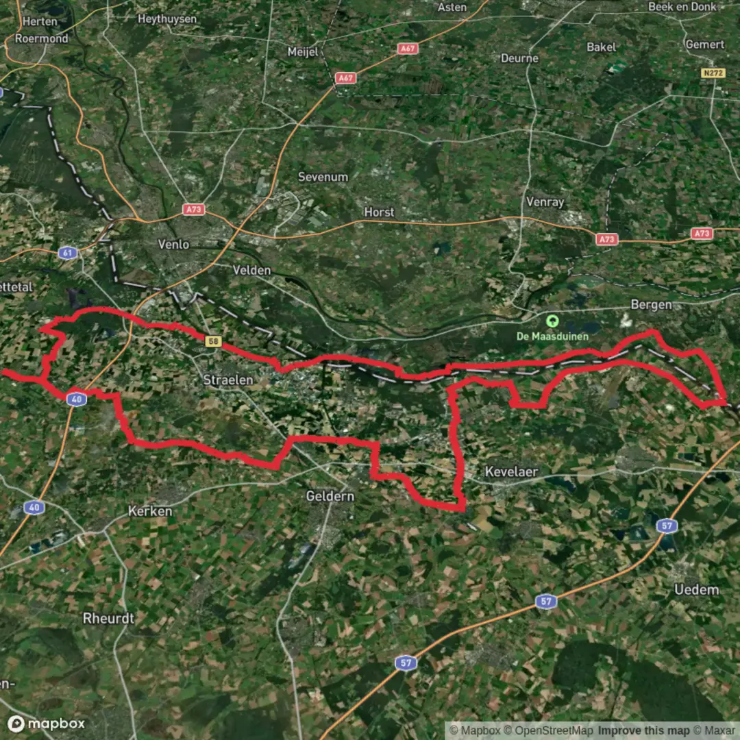
110.3 km
~4 days
18 m
Multi-Day
“A time-rich Maasduinen ramble through dunes, pines, heath and shimmering fens—sand and soggy edges included.”
This is a long, lowland ramble through the northern half of Nationaal Park De Maasduinen and its “string-of-pearls” landscapes: sandy river dunes, pine-and-oak woodland, open heath, and a chain of fens/ponds (vennen). At around 110 km / 68 mi with roughly 0 m / 0 ft of climbing, the challenge isn’t steepness—it’s time on feet, sandy sections, and staying dry around the wetlands.
Where the hike starts (nearest address / landmark)
The most practical “Dorperheideweg” start landmark is by the holiday parks and trail access on the edge of Arcen:
- Resort Arcen / Klein Vink area, Dorperheideweg 12, 5944 NK Arcen (Venlo), Netherlands (good as a navigation anchor and common access point to Dorperheide). (resort-arcen.nl)
Another clear landmark on the same road is:
- Campland Arcen, Dorperheideweg 45, Arcen (also useful as a pin if you’re meeting others). (waze.com)
If your GPX start is “near” Dorperheideweg but not exactly at these, use HiiKER to snap the start to the closest trail entrance/parking pull-off along Dorperheideweg.
Getting to the start (car + public transport)
By car - Aim for Dorperheideweg (5944 NK), Arcen and park at/near the recreation parks or designated trail parking where permitted. This area sits between Arcen and the Maasduinen landscapes, so it’s a convenient gateway into the route’s first nature blocks. (postcode.site)
By public transport - The nearest larger rail hub is typically Venlo (regional connections), then continue by bus/taxi toward Arcen. From Arcen village you’ll still have a short road-walk or local transfer to Dorperheideweg. Because bus routes and timetables change, check the current options and last return times before committing to a full-day stage.
What the terrain feels like over 110 km / 68 mi
Expect a repeating rhythm: - Firm forest tracks (easy cruising, good for steady pacing) - Soft sand on dune ridges and heath edges (slower, more tiring than the elevation profile suggests) - Wet margins near fens/ponds (muddy after rain; occasional waterlogged path segments)
Even though the elevation gain is near zero, the Maasduinen system is built from river dunes—subtle rises and dips that don’t add much “gain” but do add constant micro-undulation and changes in footing. The “easy” rating is accurate for technical difficulty, but the distance makes it a serious endurance walk.
Dorperheide: water, reeds, and birdlife early on
Dorperheide sits as a nature link between other Maasduinen estates/areas and includes sand and gravel pits that have been shaped into wildlife-friendly waters with reedy edges and marshy banks. (limburgs-landschap.nl)
What that means on the ground:
- You’ll pass open water with reedbeds—excellent for scanning birds.
- It’s a strong area for migrating waders stopping to rest, plus reed-nesting birds (you’ll often hear them before you see them). (limburgs-landschap.nl)
- In warm months, expect plenty of dragonflies around the wet margins. (limburgs-landschap.nl)
Watch-outs here
- After wet periods, some connectors can be temporarily soggy or partly impassable; plan small detours on parallel tracks if needed and keep HiiKER handy for quick reroutes. (wandelknooppunt.nl)
- Mosquitoes/gnats can be noticeable near still water in summer—pack repellent if you’re sensitive.
Heerenven, Diekmes, and the “vennen” chain: quiet wetlands with fragile edges
As the route links Dorperheide with Heerenven and onward toward Diekmes, the character becomes more “fen-and-heath mosaic.” In this part of the Maasduinen, the most important practical detail

Surfaces
Asphalt
Unknown
Concrete
Sand
Gravel
Paved
Comments and Reviews
User comments, reviews and discussions about the Dorperheide, Heerenven, Eckeltse Bergen and Diekmes via Dorperheideweg, Germany.
average rating out of 5
0 rating(s)