Download
Preview
Add to list
More
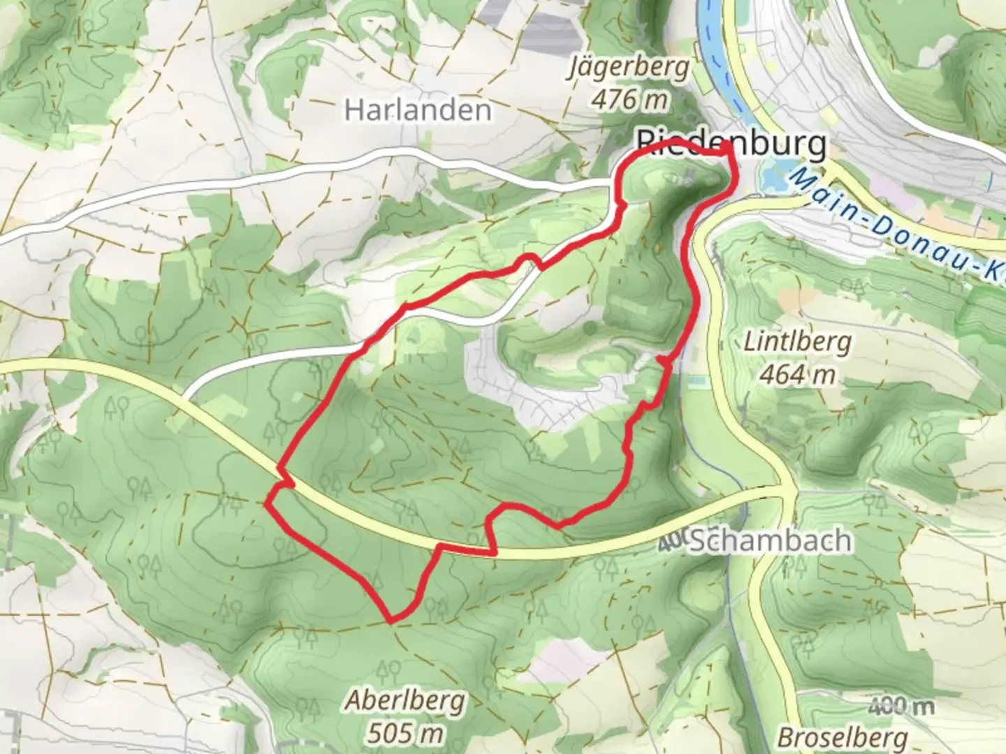
8.3 km
~2 hrs 6 min
266 m
Loop
“Explore Kelheim's scenic history on the 8 km Rundweg Riedenbeurg Loop, perfect for moderate hikers.”
Starting near the charming town of Kelheim, Germany, the Rundweg Riedenbeurg Loop is an 8 km (approximately 5 miles) trail with an elevation gain of around 200 meters (656 feet). This loop trail offers a medium difficulty rating, making it suitable for moderately experienced hikers.
Getting There
To reach the trailhead, you can either drive or use public transportation. If you're driving, set your GPS to Kelheim, and look for parking near the town center. For those using public transport, Kelheim is well-connected by bus services from nearby cities like Regensburg. The nearest significant landmark to the trailhead is the Liberation Hall (Befreiungshalle), a prominent historical monument in Kelheim.
Trail Overview
The Rundweg Riedenbeurg Loop begins near the Liberation Hall, a neoclassical monument built to commemorate the victories over Napoleon during the Wars of Liberation. This historical site offers a glimpse into the region's rich past and provides a stunning panoramic view of the surrounding landscape.
Key Sections and Landmarks
Initial Ascent
The trail starts with a gentle ascent through a mixed forest of beech and oak trees. This section is about 2 km (1.2 miles) long and gains approximately 100 meters (328 feet) in elevation. Keep an eye out for local wildlife such as deer and various bird species. The forest floor is often carpeted with wildflowers in the spring, adding a splash of color to your hike.
Midway Point
Around the 4 km (2.5 miles) mark, you'll reach the highest point of the trail. Here, you'll find a small clearing with a bench, perfect for a short rest. The elevation gain at this point totals around 150 meters (492 feet). From this vantage point, you can enjoy sweeping views of the Altmühl Valley and the Danube River.
Descent and Return
The descent begins gradually, winding through more forested areas and eventually leading to open meadows. This section is about 4 km (2.5 miles) long and descends approximately 100 meters (328 feet). The meadows are home to various wildflowers and butterflies, making it a picturesque end to your hike.
Navigation and Safety
For navigation, it's highly recommended to use the HiiKER app, which provides detailed maps and real-time updates. The trail is well-marked, but having a reliable navigation tool ensures you stay on track.
Flora and Fauna
The Rundweg Riedenbeurg Loop is rich in biodiversity. The mixed forests are home to a variety of tree species, including beech, oak, and pine. Wildlife sightings are common, with deer, foxes, and numerous bird species frequently spotted along the trail. In the spring and summer, the meadows burst into bloom with wildflowers, attracting a plethora of butterflies and bees.
Historical Significance
Kelheim and its surroundings are steeped in history. The Liberation Hall, near the trailhead, is a significant historical monument. Built between 1842 and 1863, it stands as a testament to the region's role in the Napoleonic Wars. The trail itself passes through areas that have been inhabited since prehistoric times, adding an extra layer of historical intrigue to your hike.
Final Stretch
As you approach the end of the loop, you'll re-enter the town of Kelheim. This final section is relatively flat and easy, allowing you to cool down as you make your way back to the starting point near the Liberation Hall.

What to expect?
Activity types
Comments and Reviews
User comments, reviews and discussions about the Rundweg Riedenbeurg Loop, Germany.
average rating out of 5
0 rating(s)