Download
3D Flyover
Add to list
More
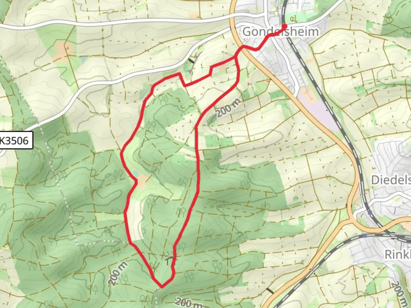
8.9 km
~2 hrs
142 m
Loop
“The Karrheckenweg trail near Karlsruhe offers a scenic 9-kilometer hike rich in nature and history.”
Starting near Karlsruhe, Germany, the Karrheckenweg is a delightful loop trail that spans approximately 9 kilometers (5.6 miles) with an elevation gain of around 100 meters (328 feet). This medium-difficulty trail offers a mix of natural beauty, historical landmarks, and a serene hiking experience.
Getting There
To reach the trailhead, you can either drive or use public transport. If driving, head towards the village of Durlach, which is a well-known suburb of Karlsruhe. There are several parking options available near the starting point. For those using public transport, take the S-Bahn to Durlach station. From there, it's a short walk to the trailhead.
Trail Overview
The Karrheckenweg loop begins near the Turmberg, a prominent hill in the area. The trail is well-marked and maintained, making it suitable for hikers with moderate experience. As you start your hike, you'll be greeted by a gentle ascent through mixed forests, offering a cool and shaded environment, especially pleasant during the warmer months.
Key Landmarks and Points of Interest
- Turmberg: At the beginning of your hike, you can take a slight detour to visit the Turmberg, which offers panoramic views of Karlsruhe and the surrounding region. The Turmberg is historically significant, with remnants of a medieval castle that once stood here.
- Wildlife and Flora: As you continue, keep an eye out for local wildlife such as deer, foxes, and a variety of bird species. The trail is also rich in flora, with oak, beech, and pine trees dominating the landscape.
- Historical Sites: Around the 4-kilometer (2.5-mile) mark, you'll come across the ruins of an old Roman watchtower. This site provides a glimpse into the region's ancient history and its strategic importance during the Roman era.
- Scenic Meadows: Midway through the hike, the trail opens up into scenic meadows, offering a perfect spot for a picnic. These meadows are particularly beautiful in spring and early summer when wildflowers are in full bloom.
Navigation and Safety
For navigation, it's highly recommended to use the HiiKER app, which provides detailed maps and real-time updates. The trail is generally well-marked, but having a reliable navigation tool ensures you stay on track.
Final Stretch
As you approach the final stretch of the loop, the trail descends gently back towards Durlach. This section offers more open views and a chance to reflect on the diverse landscapes you've traversed. The descent is gradual, making it a comfortable end to your hike.
Practical Tips
- Footwear: Wear sturdy hiking boots, as some sections can be uneven and rocky.
- Water and Snacks: Carry enough water and snacks, especially if you plan to take breaks at the scenic spots.
- Weather: Check the weather forecast before heading out, as the trail can become slippery in wet conditions.
The Karrheckenweg offers a well-rounded hiking experience with its mix of natural beauty, historical landmarks, and moderate challenge. Whether you're a local or a visitor, this trail provides a perfect escape into nature just a short distance from Karlsruhe.

Comments and Reviews
User comments, reviews and discussions about the Karrheckenweg, Germany.
average rating out of 5
0 rating(s)